How-to use VDatum (USA) for .qgfvom and Geoid Model (.bin)
This page describe how to create .qgfvom or .bin geoid model using NOAA’s VDatum tool.
1 - Create an Lat, Long, Height (0) file to input in Vdatum
Create your project in Qinsy and select the proper geodetic parameters.
In this example we are using NAD83(2011)/UTM zone 19N as the Project Coordinate System and ITRF2014 as the Source Coordinates System: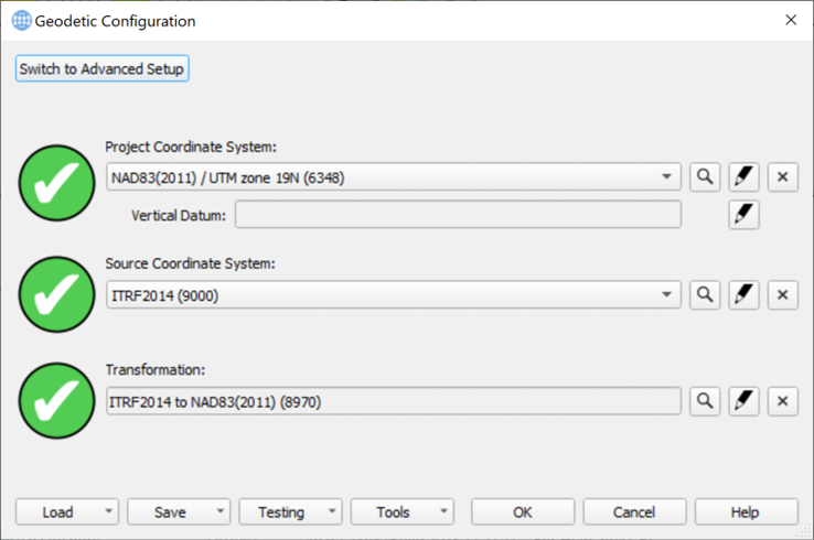
Open Survey Manager and navigate to the location where you want to create your model.
For a VOM file it is possible to use the extent of the plan view for coverage (see step 4 below, ‘Used Area’ parameter), but it is recommended to create a new area to cover the location of the model. If you are unsure how to create a new area, you can see the steps in the offline help pages (Click F1 and navigate to relevant pages, or use the following link if you have Qinsy version 9.7.1 or newer installed: http://localhost:7027/Help/Page/EN/Survey-Manager-Create-Areas_42077382).: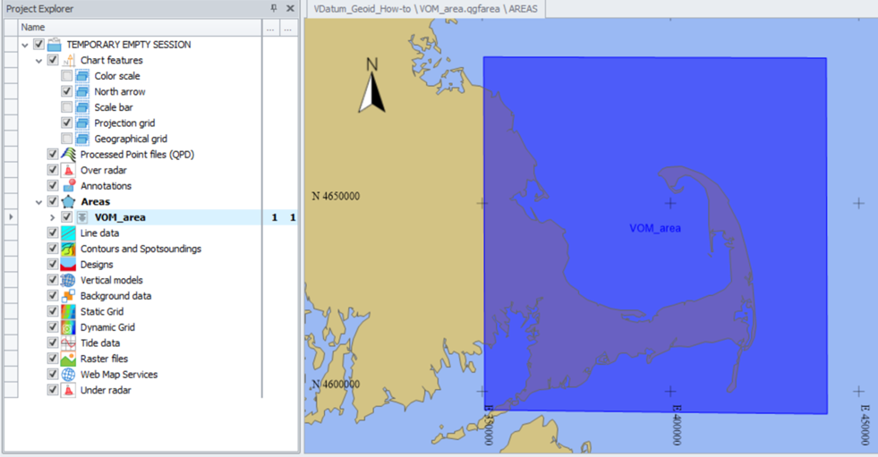
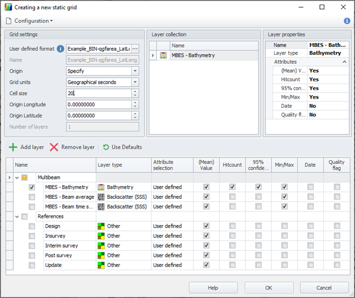
Create a new empty Static Grid with the cell size equivalent to the resolution you want for your model; the cell size will also have an impact on the final file size, which will help determine whether you should be utilizing a .qgfvom or a .bin model. See How-to Create a Geoid or Vertical Offset Model (VOM) for pointers on whether you should be working with a .qgfvom or .bin file.
Allow one layer in the grid: this will be the layer used to create the ASCII file.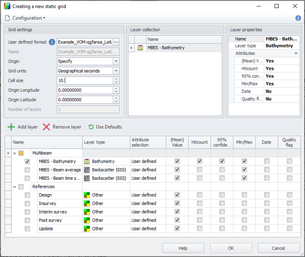
Once the grid is created, right click it and select 'Import'. Use the fill operations to fill the Static Grid with points, using the ‘Single Value’ fill method. Set the value to 0, so that the resulting file from Vdatum will contain z values of ONLY the desired height difference!
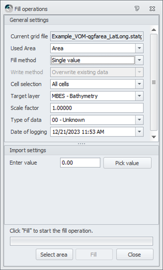
You’ll need to select the .qgfarea in the plan view before filling the grid if an predefined area is being used.
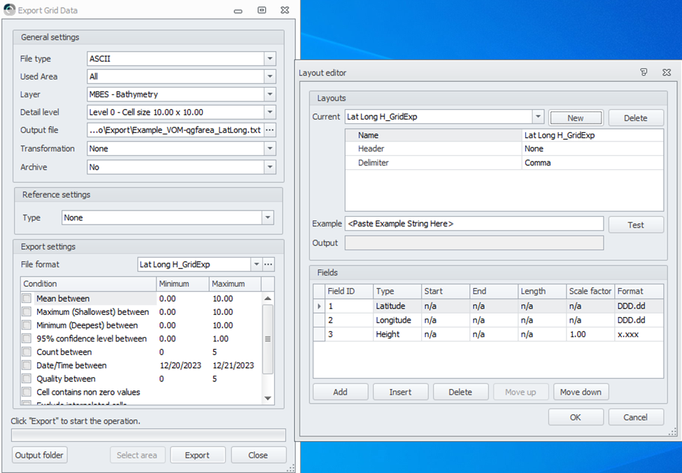
Once the grid is filled, export it to create the ASCII file. Make sure you have the proper configuration for the export: Lat(DD.dddd), Long(DD.dddd), Height(X.xxxx)
2 - Create a separation ASCII file with VDatum
Download the VDatum desktop version from the NOAA website (VDatum download).
It is strongly recommended to use the desktop version of VDatum instead of the online version, as this one has no file size limitations and seems to work better generally.To open the app, double click on the .bat (vdatum.bat) file inside the downloaded folder.
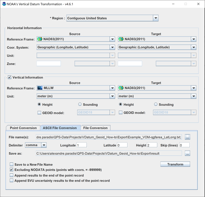
In VDatum, use the following configuration to compute the separation:
Set the region based on where your file is valid for!
Select the ‘Contiguous United States’ option if there is not a more specific option for you.
To comply with the sign conventions in Qinsy, the Source and Target sections must be swapped in VDatum:
Source will be the datum we want to reach
Target will be the datum of the file we just created in Survey Manager.
Make sure the import configuration is correct in regards of the file you import in VDatum.
Tick “Excluding NODATA points” to create a smaller file with only useful data.
Once the transformation is complete, a new “result” folder should appear in the folder where your ASCII file comes from.
The ASCII file with the computed separation will be in that folder.
3 - Create a .qgfvom file
4 - Create a .bin geoid model
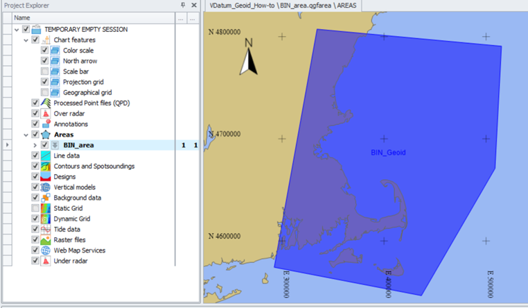
In order to create a BIN Geoid model, a regular spaced grid using geographical coordinates is required.
To make sure your grid will be equally spaced, create a .qgfarea over the area you want your model to cover:It will be used as the extent of the Static Grid from which we’ll create the separation ASCII file (Part 1).
Create, fill with 0s and export your Static Grid from the qgfarea using a Lat, Long, Height (0) configuration.
Use VDatum to compute the separation between your 0s Grid and the datum you want to have your data in.
Source will be the datum to reach
Target will be the datum of the file uploaded (from Survey Manager).
Make sure the import configuration is correct in regards of the file you import in VDatum.Tick “Excluding NODATA points” to create a smaller file with only useful data.
Once the transformation is complete, the ASCII file with the computed separation will be in the “result” folder.
With the resulting file from VDatum, follow these steps to create a .bin geoid model:
How-to Create a Geoid model (.bin) before Qinsy 9.8.0In order to use your BIN Geoid Model into your geodetic parameters, a wkt file needs to be created. Follow these steps to create the associated wkt file for your geoid model:
How-to Use the Geoid Model Migration ToolTest your geodetic setup with VDatum to make sure you are good to go (See Step 6).
5 - Testing the resulting file
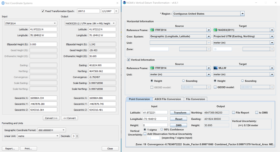
From the Geodetic Configuration menu, select the Test Coordinate System… tool to make sure your file works properly.
Select in the input your Source Coordinate System.
Select in the output your Project Coordinate system + Height Model.
Type in the coordinates (Lat/Long) of a point inside the area of your .qgfvom file and select 0 as Ellipsoidal Height.
Click on Convert>> to translate your input coordinates.
Keep that window open as reference.
Form the VDatum desktop app or website, select the Point Conversion tool the cross-check the transformation you have in the Test Coordinate System… in Qinsy.
Select the Source Coordinate System of your project as Source.
Select the Project Coordinate System + Vertical information as Target.
Type the same coordinate you use in Qinsy and click on Transform.
Make sure to select the same Transformation Epoch as the one you have in Qinsy, otherwise you might see some difference in the result.
Validate the result between Qinsy and VDatum: should be the same!