
Introduction
Qpd files are QPS's processed survey point files and these files can be directly opened as an object type in Fledermaus and used for visualization and/or in various operations. They share a lot of properties with the Point object type.
Storage Format
Processed sounding/lidar data from Qinsy and Qimera are written to QPD files with the extension .qpd and these files can be directly loaded into Fledermaus for visualization, operations, and further analysis.
Properties
This object does not have an object specific properties.
Attributes
This object type shares much in common with the Points object and provides a similar set of attribute tailored to the needs of this type.
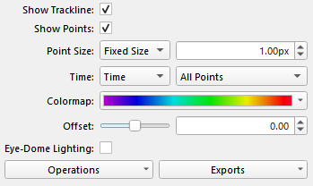
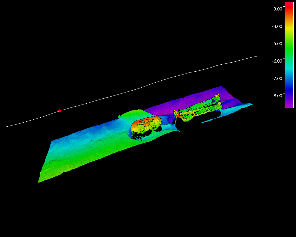
Given this is a survey points format we generally have a track line for the ship or survey vehicle which is shown by default as you can see in the example above. The system will also know the time range over which the data was collected and as you move the Fledermaus Time Bar to different times one can see a red dot plotted on the track line to show the vehicle's position at that point in time. The Show Trackline toggles lets one turn this track line off or on in the display.
The Show Points toggle lets you specifically toggle the display of the points off and on separate from the track line.
The Point Size is limited to Fixed Size for this object type but you can control the size of the point pixels displayed.
The Time attribute works similarly to the time attribute in regular points. You can choose which column of the data is used as the time and if the Fledermaus should show all the points, only past points, or only points within a time window around the vehicle's position.
The Colormap widget provides the control of the color map selection and mapping.
The Offset is a simple vertical offset applied to the visualization of the points, the internal data is not modified by this offset.
The Eye-Dome Lighting toggles turns on/off this point illumination algorithm which can improve the visualization of the points and help show their depth. When enabled two extra options are available which control how the algorithm illuminates the points.
Operations
To see the operations available for the point object type right click the object's name and look in the Operations sub-menu or look at the Operations dropdown menu at the bottom left of the attribute panel. These operations include:
Change Object Coordinate System
While this should be very rarely needed it can be used if necessary to change the coordinate system currently applied to the object. No projection is done here you are just telling it that this new coordinate system is what the object should have been in in the first place.
Create Surface
This operation provides a convenient method to create a surface for any selected QPD objects. See the gridding documentation for details on making a surface from points.
Create Mesh
This provides a quick way to start the mesh creation process on any selected QPD objects. See the Meshing documentation for details on the processing.
Exports
There are currently no additional exports for the QPD Object type.
Return to Fledermaus Visual Objects
Return to Fledermaus Reference Manual