Skip table of contents

QGF File types

.qgf used to be a file extension that would contain all types of data described below in a single file. For reasons of portability of separate components of that file, it's been partitioned by contents into several file types.

Purpose

Below an overview of the purpose of each file type and some additional notes:

QGF type

Purpose

Notes

QGFAnno

  • Show markers/Icons/Areas in the Navigation display and Survey Manager.

  • Can only contain one layer.

  • Can contain extra notes or attached files.

QGFArea

  • Qinsy Online

    • Can be loaded into Session Setup → Planning → Line Databases to be used for:

      • Auto recording within the area;

      • Setup the area in the Echosounder Settings to filter data inside or outside an area.

    • They can also be loaded in the Navigation display directly for visualization only.

  • Survey Manager

    • Horizontal area in which volumes can be calculated;

    • Can be used as a boundary to clip survey lines;

QGFBack

  • Displaying background information.

Cannot be edited so for example No-Go areas cannot be accidentally altered.
This is for safety reasons.

QGFCont

  • These files are created from Grids and can contain contour lines and spot soundings.

  • Often used for plotting data and exports.

QGFDesign

  • Qinsy Online

    • You can select qgfdes files in the Session Setup → Planning → Additional Terrains.

      • This way you can do a live comparison between you survey data and the design.

    • You can also select qgfdes files in Session Setup → Dredging → Design;

      • You can then use this as a reference in several displays;

      • You will need to add a Dredge system to your template.

    • QGFDes files can also be directly loaded in the Profile display visualization.

  • Survey Manager

    • Can be used in volume calculation to calculate the difference between the grids (in-survey, update-survey, current survey, etc.) and the design.

    • You can also show it in the Profile view if this is enabled. You can do this by:

      • Right-clicking on the Layer and toggle it on/off;

      • Select the layer and use the checkbox in the Properties dock;

      • Select the layer and use Shift+1

  • Must contain a triangle mesh (Linked).

  • You can also import a design into a Static Grid.

QGFLine

  • Qinsy Online

    • Can be used for planning and can be “Active”

      • Points, Lines and Polylines (Routes) can all be active.

    • The Active mainline can then be used as a reference in several displays for example show KP/Offset:

      • Navigation

      • Profile

      • Helmsman;

      • Generic;

      • Swath System;

      • 3D Grid.

    • QGFLine files can be used for Intrusion detection in Dredging operations.

  • Survey Manager

    • Your survey plan can be created in the file format.

    • You can Activate Lines/Routes in the Survey Manager so you can:

      • See KP/Offset;

      • Create KP markers

    • You can create preplot shapes in this file that can be visualized in the Navigation display;

    • Lines/Routes can be used as a KP/Offset reference for some export modules;

    • You can also show Line and Polyline that intersect with a profile, by enabling the Show intersection lines button in the Profiles ribbon.

  • Should not be used for displaying large amount of background information.
    Instead you can use QGFBack files for this.

QGFVOM

This file can be used if you have custom height shifts that are different in different locations which you can then triagulate.
These custom height shifts can for example be between:

  • Ellipsoid and Chart Datum/MSL/LAT;

  • MSL and LAT.

Note that this file is only intended for small areas with not a lot of points.
This because larger files can have a performance impact on Qinsy Online.

More info can be found here: How-to Create a Geoid or Vertical Offset Model (VOM)

  • You can also show it in the Profile view if this is enabled. You can do this by:

    • Right-clicking on the Layer and toggle it on/off;

    • Select the layer and use the checkbox in the Properties dock;

    • Select the layer and use Shift+1

  • Must contain a triangle mesh layer called GEOIDPOINTS.

  • You can also import a VOM into a Static Grid the same as you would do for a Design file.

Data types per filetype

This is a rough outline of what data can/will be expected in what file type (fields marked “i” mean the data type can only end up there through imports, not through Survey Manager’s user interface):

 File extension

Annotation

Point

Line

Area

Point cloud

Triangle mesh

Pre Plot Shapes

.qgfanno

(tick)

(tick)

(tick)

(tick)


(tick)

.qgfarea


(tick)


(tick)

.qgfback

Import only

Import only

(tick)

Import only

Import only

(tick)

Import only

.qgfcont


(tick)

(tick)


.qgfdes

(tick)

(tick)

(tick)

(tick)

(tick)

.qgfline


(tick)

(tick)


(tick)

.qgfvom

(tick)

(tick)

Action per filetype

Theoretically, any of the .qgf* file types could contain anything, but what is actually in them is gated by the Survey Manager. This table shows what is allowed per file type and action. “r” means read only - data will be viewable but not editable.

Action

.qgfanno

.qgfarea

.qgfback

.qgfcont

.qgfdes

.qgfline

.qgfvom

Create annotation

(tick)

Color scale settings

(tick)

Edit layers

(tick)

(tick)

Drape

(tick)

(tick)

Generate DTM link / Fill sounding grid / Volume calculation

(tick)

(tick)

Import Profil-2000

(tick)

(tick)

Import/export L84

(tick)

(tick)

(tick)

Generate raster

(tick)

(tick)

(tick)

Wing/cross lines

(tick)

(tick)

(tick)

Create point/line

(tick)

(tick)

(tick)

(tick)

Create area

(tick)

(tick)

(tick)

(tick)

Select in plan view

(tick)

(tick)

(tick)

(tick)

Cut/paste/remove/duplicate/clip/move/create (see note 3)

(tick)

(tick)

(tick)

(tick)

(tick)

Edit points/(poly)lines

(tick)

Read only

Read only

(tick)

(tick)

(tick)

Edit areas

(tick)

(tick)

Read only

Read only

(tick)

(tick)

Import/export (see note 1)

(tick)

(tick)

(tick)

(tick)

(tick)

(tick)

Export (see note 2)

(tick)

(tick)

(tick)

(tick)

(tick)

(tick)

(tick)

NOTE 1: This encompasses the following:

Click here to expand...
  • Imports:

    • ASCII line offset

    • ASCII text file

    • Geobas

    • Navigation channel

    • SZ

    • WSA

    • AutoCAD DWG

    • AutoCAD DXF

    • Google Earth KML

    • LandXML

    • Terramodel

    • ESRI shape

  • Exports:

    • LandXML

    • ASCII line offset

    • Kongsberg

    • Maridan

    • Vertical offset model

NOTE 2: This encompasses the following exports:

Click here to expand...
  • ASCII Lat/Lon

  • ASCII X/Y/Z

  • AutoCAD DWG

  • AutoCAD DXF

  • Google Earth KML

  • Terramodel

  • Shapefile

NOTE 3: The following object types can be added and edited:

Click here to expand...
  • Shape

  • Object (which is a point/line/polyline/area)

    • In Area files, points and lines are discarded, and polylines are always made into areas

Q&A on QGF files

Question

Answer

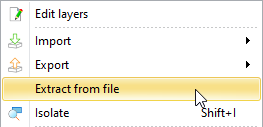
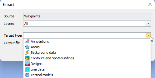
How can a convert one QGF file type into another?

In the Survey Manager you can right click on a qgf file and extract data from a file and create a new type:

  • image-20240828-133900.png
  • image-20240828-134002.png

We have made it impossible to simply change the file extension to prevent users from using date types in file-types that would cause problems in other parts of our software.

Additional QGF file types

Qastor 2.5

The older Qastor version also supports an older version with extension *.qgf for annotations.

  • This is not supported in Qinsy;

  • This is not supported in Qastor 3.

    • Geojson is used for annotations in this version.

Navigation display QGFNav

When loading in any of the file types (QGFLine, QGFBack, QGFArea, etc.) into the Navigation dispay, a related QGFNAV file is created to visualize things in the navigation display.

  • The only purpose of this file is also to visualize things in the display.

  • If you load in a QGFLine file for example in 2 Navigation displays, one QGFNav file is created for each display.

  • The file is located here: <project location>\Settings\Display\<Display set name>\Qad\<Navigation display name>\Linedatabases

  • The QGFNav file will be deleted after it is no longer loaded into the display.

JavaScript errors detected

Please note, these errors can depend on your browser setup.

If this problem persists, please contact our support.