Exporting Seismic - User Defined ASCII from PM
On this page:
Suitability to Seismic
If 'dummy echosounders' have been defined for most, if not all, objects in the seismic spread, this Processing Manager export option provides a means to write line and node positioning related data to an ASCII text file.
Sometimes a client may ask for information in a format other than P1/90 or SPS.
This export does not provide the usual header information found in UKOOA/OGP data exchange files. Another difference in output is that P1/90 exports all node positions for one fix at a time whereas this export writes positions for one node at a time for all fixes.
Overall, other export programs may be more useful, i.e. those from the Raw Data Manager - 'UKOOA P1/90', and 'All Data-Generic Export'.
General Options
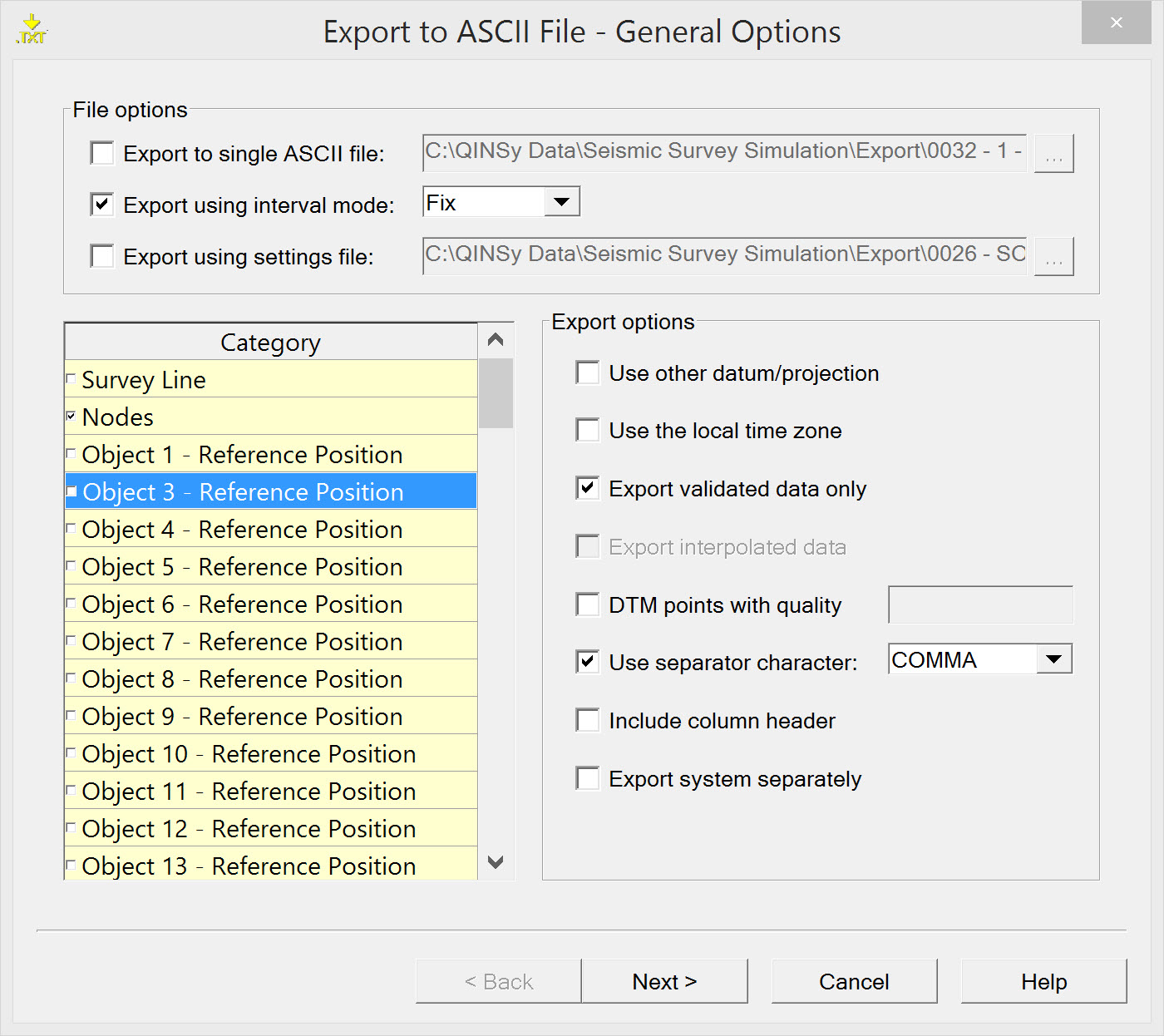
On the first page of the export wizard select the options that specify which data needs to be exported and where it needs to be stored.
In seismic surveys:
- Export is usually done line by line, not to a single ASCII file.
- Export is usually based on Fix mode.
- It is probably wise to save the export configuration to a 'settings file'.
- The category list includes Survey Line, Nodes, all Object Reference Positions, all echosounder DTM points and transducer points (almost all of which are 'dummy echosounder' systems set up to facilitate storage of all objects in the *.QPD file). Survey Line and Nodes are of primary interest.
- For export options DTM points are probably of no interest.
Info
The options selected on this page determine the appearances of the next wizard pages.
| File options | |
|---|---|
| Export to single ASCII file | Tick when data needs to be exported to a single ASCII file. Enter a name for the file. Click the browse button to change folders. Select the folder to which the file or files are saved. |
| Export using interval mode | There are various modes to use: |
| Export using settings file | Use a previously created ASCII Export Settings file for the export configuration. For the first time of running the wizard there is no Settings file already stored. Proceed through the wizard and the option to save a Settings file is provided on the last page of the wizard. If an existing Settings file is selected here, any changes to the configuration made on this and subsequent pages of the wizard can be saved to a new Settings file at the end of the Export ASCII configuration wizard. |
| Category | |
| Survey Line | Export parameters associated with the theoretical survey line attached to the *.qpd file. |
| Nodes | Export any Nodes defined on any or all Objects in the Template database. |
| Reference Position of the used objects | The reference position of the vessel and/or any other object used. |
| DTM Points | The positions (X, Y, Z) of the footprints from one or more systems. |
| TD Positions | The position(s) of the transducer(s) (TD) from one or more systems. |
| Export options | |
Use other datum/projection | The data is recorded on Survey datum as set in Database Setup. With this option the data can be converted to another datum and/or projection. |
Use the local time zone | By default all data is stored in UTC time. With this option the time will be converted to local time according to the MSWindows date and time settings. |
Export validated data only | Data which is set to 'not valid' in the Validator will not be exported. |
Export interpolated data | This option can only be used when the export option 'Export using interval mode' was selected and was set to MP. This interpolates in the area between QPD files. |
| DTM points with quality | Only export points with a quality figure entered in the text box provided. |
| Use separator character | Select the character which will be used to separate the different fields in the export file. |
| Include column header | It is possible to add a header to exported data. The header has two lines:
The header will precede the exported data. |
Export system separately | When a dual channel echosounder (33 and 210 kHz) needs to be exported to a single file, the export module sees the two transducers as two systems. Enabling this option enables dual channel export. If an echosounder (33 and 210 kHz) needs to be exported to a single file, the export module can treat the two transducers as one system. The precision formatting time fields have to be the same for all transducers. If this is not the case no identical timetags will never be found. |
Return to 43514727.
Survey Line Parameters
This page will only appear when the Category "Survey Line" was selected on the first page of the wizard. There are two slightly different versions depending on whether a field separator is used or not.
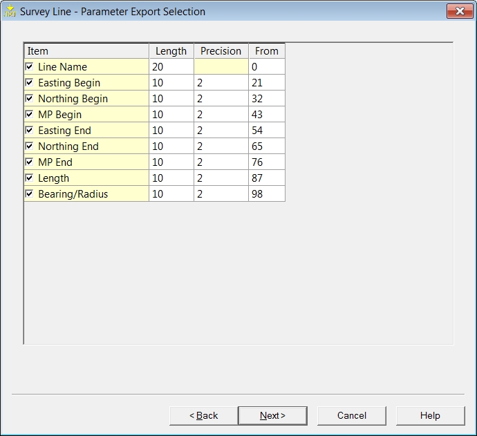
Normal appearance of columns.
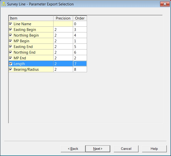
Appearance of columns after activating 'Use separator character' in 'General Options' wizard page.
| Survey Line - Parameter Export Selection | |
|---|---|
| Item | Select which line associated parameters should appear in the ASCII file. (See table below.) |
| Length | For each item the length of the data field needs to be set. (Normal appearance of columns.) |
| Precision | Enter the number of decimals used (precision). |
| From | Enter the starting column in the file for this item. |
| Order | This column is used to specify the sequence of exported parameters. (Appearance of columns after activating 'Use separator character' in 'General Options' wizard page.) |
For each line the following items can be exported:
| Item | |
|---|---|
Line Name | Name of the attached line. |
Easting Begin | East coordinate of the beginning of the line. (Not necessarily the SOL.) |
Northing Begin | North coordinate of the beginning of the line.(Not necessarily the SOL.) |
MP begin | MP (Meter point) value at the beginning of the line. |
Easting End | East coordinate of the end of the line. (Not necessarily the EOL.) |
Northing End | North coordinate of the end of the line. (Not necessarily the EOL.) |
MP End | MP (Meter point) value at the end of the line. |
Length | Total length of the line. |
Bearing / Radius | If the radius of the line is zero the bearing of the line will be shown, otherwise the radius of the line will be shown. |
Return to 43514727.
Node Parameters
This page is shown only when the Category "Nodes" was selected on the first page of the wizard. The selected set of parameters for each node selected is exported at an interval set on the first page of the wizard, i.e. the 'Export using interval mode' has been checked on the first page of the wizard and a mode selected. If no interval is set, parameter values are written to file at the update rate of the triggering system, i.e. the computation cycle time.
All parameter values for the first node in the list are written to file for the entire *.QPD file, followed by all the values for the second node for the entire *.QPD file, followed by all the values for the third node and so on.
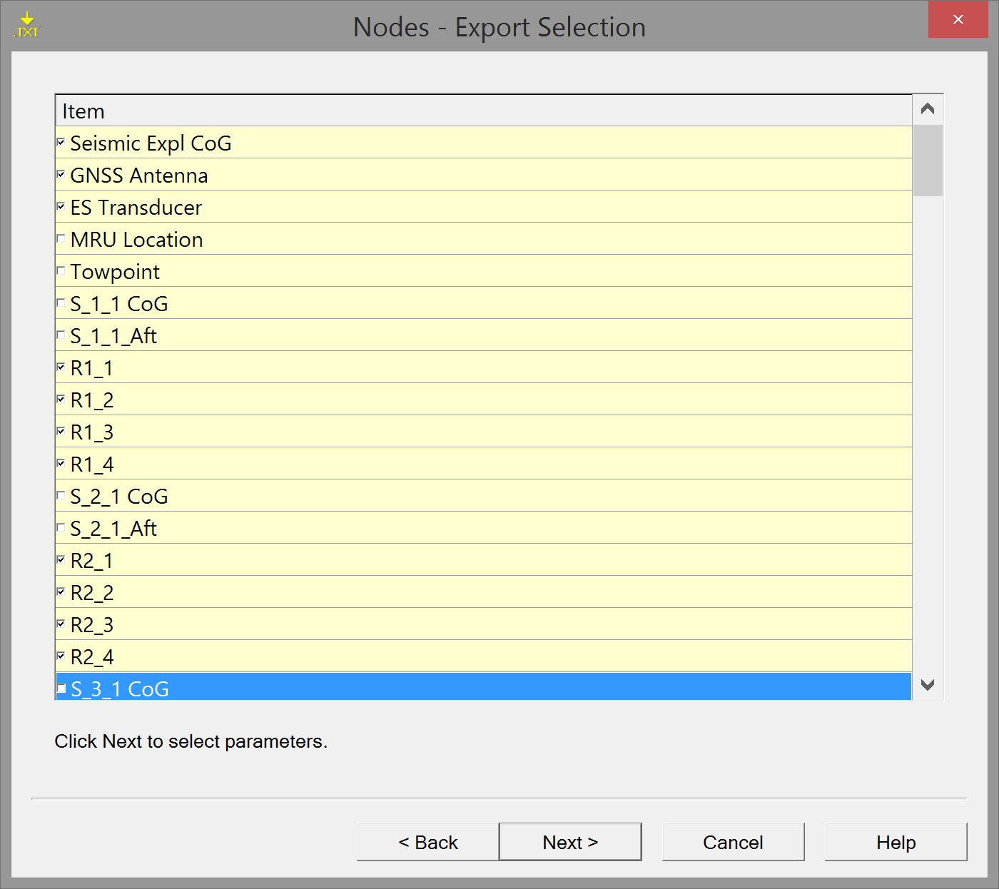
A list of items shows all available nodes.
Tick which ones need to be exported and press Next.
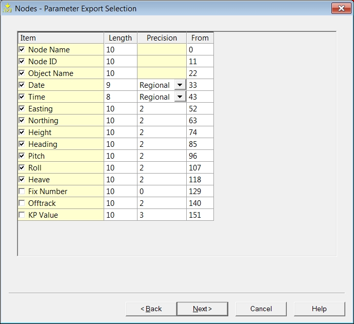
| Nodes - Parameter Export Selection | |
|---|---|
| Item | Select which Node associated parameters should appear in the ASCII file. (See table below.) |
| Length | Set the length of the data field for each item. |
| Precision | Enter the number of decimals used (precision). Regional - Settings for date and time are set in the control panel of MSWindows. Use the drop down button to select another format if necessary. |
| From | Enter the starting column in the file for this item's data. |
| Item | |
|---|---|
Node Name | The name of the node to be exported. |
| Node ID | ID code of the node. Node ID is assigned by the program and cannot be changed. |
| Object Name | The name of the Object on which the node is located. |
Date | Date of recording. |
Time | Time of recording. |
Easting / Northing | Grid coordinates of the node. |
Height | The z value of the node. |
Heading | Grid bearing of the Object on which the node is located. |
Pitch | Pitch of the Object on which the node is located. |
Roll | Roll of the Object on which the node is located. |
Heave | Heave of the Object on which the node is located. |
| Fix Number | Fix number (not available for every position). |
Offtrack | The offtrack distance from the survey line of a node. |
KP Value | The Kilometer Point value of the position of the node. |
Return to: 43514727
Return to: Exporting Towed Streamer Seismic Positioning Data
