
DTM data is motion and heading corrected geo-referenced footprint data from an echosounder (multibeam, multi-transducer or singlebeam) or laser scanner system.
The DTM data can be stored in a file in several formats, ready to import into external processing software (Validator, QLOUD, Fledermaus), or other third party programs (Terramodel, CARIS, Cyclone, etc.).
|
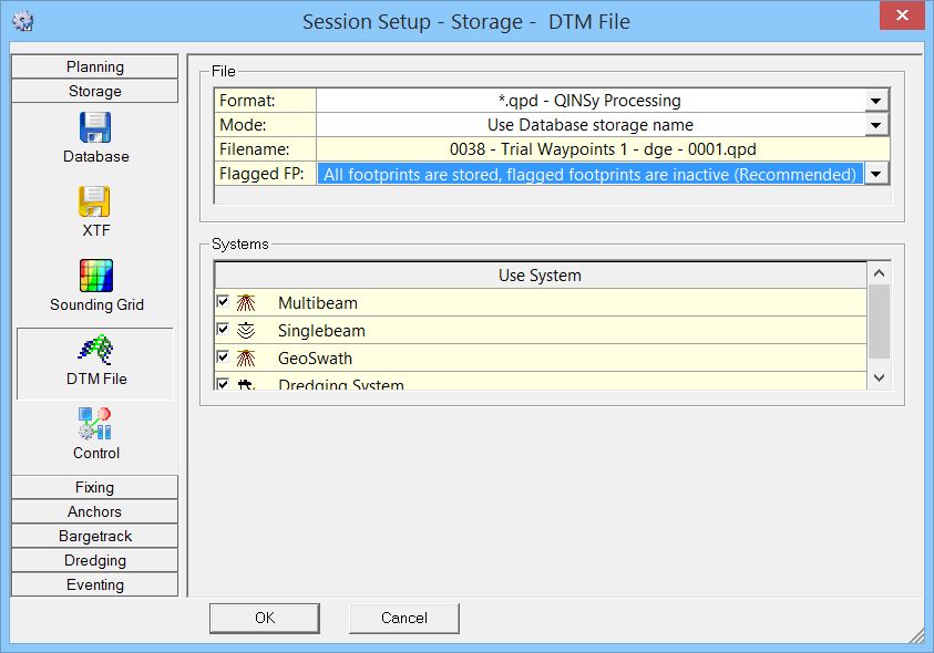
File |
|
|---|---|
|
Format |
Select one of the supported formats from the pull-down menu:
|
|
Mode |
The mode determines the name of the storage file:
|
|
Filename |
A preview of how the file name will look. |
|
Flagged FP
|
If you chose Format '*.qpd - QINSy Processing' this extra line appears where you can select from three options:
|
|
Systems |
|
|
Use System |
Activate the echosounder system(s) that should be used for the generation of the DTM file.
|
|
Layer name |
This setting is only available when File Format is set to '*.pro - QINSy Mapping'.
|
Format Descriptions
|
HEADER RECORDS |
LINE <linename>
SOL E: eeeeee.eee N: nnnnnn.nnn
EOL E: eeeeee.eee N: nnnnnn.nnn
SYSTEM ID nn <system name>
SYSTEM ID header record will be repeated for each enabled system. |
|
DATA RECORDS |
Easting Northing Depth SystemId BeamNumber ASCII, Five fields, Space separated, <CR><LF> Terminated SystemId will be a unique number identifying the system that delivered the footprint data.
|
Example
LINE RLE_LINE
SOL E: 146048.119 N: 457189.429
EOL E: 146101.903 N:
457234.224 SYSTEM ID 11 Applanix LANDMark Marine
146081.489 457214.812 0.000 11 1
146068.139 457220.543 -4.581 11 2
146068.155 457220.545 -4.576 11 3
146068.150 457220.555 -4.578 11 4
146068.165 457220.558 -4.573 11 5
146068.173 457220.563 -4.571 11 6
146068.147 457220.583 -4.580 11 7
146068.211 457220.563 -4.559 11 8
146068.215 457220.571 -4.558 11 9
146068.242 457220.567 -4.550 11 10
...
|
HEADER RECORDS |
LINE <linename>
SOL E: eeeeee.eee N: nnnnnn.nnn
EOL E: eeeeee.eee N: nnnnnn.nnn
SYSTEM ID nn <system name>
SYSTEM ID header record will be repeated for each enabled system. |
|
INTERMEDIATE RECORDS |
ID n UTC dd-mm-yyyy hh:mm:ss.sss POS 1 E: eeeeee.eee N: nnnnnn.nnn H: hhh.hhh ATT R: r.rrr P: p.ppp H: ggg.ggg |
|
DATA RECORDS |
Easting Northing Depth SystemId BeamNumber ASCII, Five fields, Space separated, <CR><LF> Terminated SystemId will be a unique number identifying the system that delivered the footprint data.
|
Example
INE RLE_LINE
SOL E: 146048.119 N: 457189.429
EOL E: 146101.903 N: 457234.224
SYSTEM ID 11 Applanix LANDMark Marine
ID 1
UTC 20-04-2012 12:50:31.669
POS 1 E: 146081.489 N: 457214.812 H: 0.000
ATT R: 0.000 P: 0.000 H: 50.000
146081.489 457214.812 0.000 11 1
146068.139 457220.543 -4.581 11 2
146068.155 457220.545 -4.576 11 3
146068.150 457220.555 -4.578 11 4
146068.165 457220.558 -4.573 11 5
146068.173 457220.563 -4.571 11 6
146068.147 457220.583 -4.580 11 7
146068.211 457220.563 -4.559 11 8
146068.215 457220.571 -4.558 11 9
146068.242 457220.567 -4.550 11 10 ...
|
HEADER RECORDS |
LINE <linename>
SYSTEM ID nn <system name>
SYSTEM ID header record will be repeated for each enabled system. |
|
DATA RECORDS |
Latitude H, Longitude H, Depth, SystemId, BeamNumber ASCII, Five fields, Comma separated, <CR><LF> Terminated Latitude and Longitude format depends on the selected Global Geographical Format Setting.
|
Example
LINE RLE_LINE
SYSTEM ID 11 Applanix LANDMark Marine
52;06;14.70806 N, 5;15;26.815 E, 0.00, 11, 1
52;06;14.89274 N, 5;15;26.113 E, -4.58, 11, 2
52;06;14.89282 N, 5;15;26.114 E, -4.58, 11, 3
52;06;14.89313 N, 5;15;26.114 E, -4.58, 11, 4
52;06;14.89323 N, 5;15;26.114 E, -4.57, 11, 5
52;06;14.89340 N, 5;15;26.115 E, -4.57, 11, 6
52;06;14.89403 N, 5;15;26.113 E, -4.58, 11, 7
52;06;14.89340 N, 5;15;26.117 E, -4.56, 11, 8
52;06;14.89364 N, 5;15;26.117 E, -4.56, 11, 9
52;06;14.89353 N, 5;15;26.118 E, -4.55, 11, 10 ...
|
DATA RECORDS |
Easting Northing Height Intensity Quality ASCII, Five fields, Space separated, <CR><LF> Terminated Number resolution always three decimals
|
Example
146081.489 457214.812 0.000 0.000 0
146068.139 457220.543 -4.581 124.000 12
146068.155 457220.545 -4.576 122.000 11
146068.150 457220.555 -4.578 100.000 9
146068.165 457220.558 -4.573 125.000 12
146068.173 457220.563 -4.571 118.000 11
146068.147 457220.583 -4.580 65.000 6
146068.211 457220.563 -4.559 6.000 0
146068.215 457220.571 -4.558 3.000 0 ...
Return to: Storage