
Windows Administration Rights - No longer required
Although the maritime industry is quite conversative it does change over time.
Connectivity, remote control and monitoring result in higher (cyber) security demands.
Qinsy always needed Windows Administrator Rights for several reasons, but has been modified to be able to run under User Rights (restricted privileges) and no longer requires Windows Administrator Rights.
Please note that Qinsy requires the option to receive and send information via COM and Network Ports. Especially the latter might involve your IT department to allow you to use certain ports for drivers or some of our background applications. For more details please refer to the following documentation:
HowTo User Privileges in Qinsy 9.6
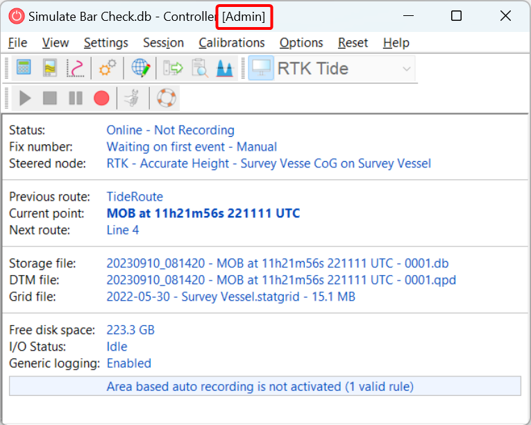
When you go Online with Qinsy the Online Controller will show you if you are running Qinsy with Administrator Rights
Timing
When no Time Synchronization System is added to the setup all observation messages (including those with time tagged observations) will be time tagged using the local computer clock.
A Time Synchronization system is mandatory for Qinsy to create its own precise clock. This clock is used for:
-
Time tagging observations (messages received) without a time tag.
-
Validating observations with a time tag to go in a buffer
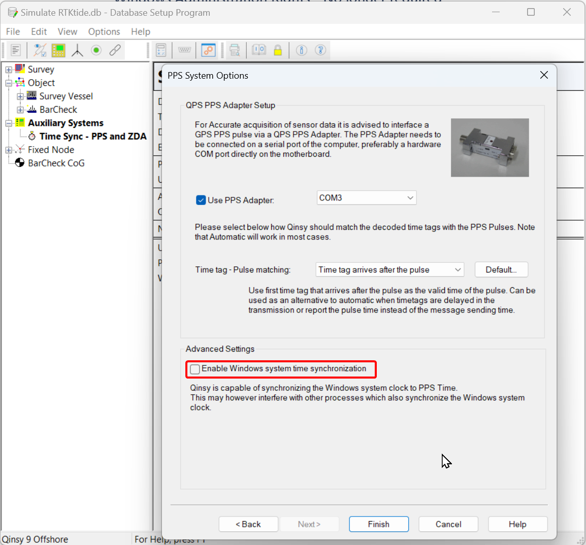
Qinsy also offers the option to Synchronize the Windows Computer Clock (see picture below), but this requires Windows Administrator Rights.
3rd Party Software using windows computer clock
Qinsy will no longer be able to adjust the Windows computer time when running without Windows Administration Rights.
This might affect you when running 3rd party software like Edgetech Discover or other software that relies on the computer clock.
For Qinsy and timing we made adjustments that it can still run the internal Qinsy clock for precise timing,
Newly added Time Synchronization Systems will have the Advanced setting for “Windows system time synchronization” turned off.
If you run an existing Template DB on a computer which now runs under (restricted) User Rights and you go Online, you might come across the following warning:
If your computer is handled by your IT department/provider its likely that the have the Windows Time Service enabled which uses a NTP server to time synchronize your computer clock. Familiarize yourself with how often this service is triggered by contacting your IT department/provider.
TPU - Total Propagated Uncertainty
Qinsy was in a lot of places still referring to the older terminology of Total Propagated Error instead of Uncertainty.
Graphical User Interface (GUI/UI) and documentation in Qinsy 9.6.0 have been updated and now refer to:
-
THU - Total Horizontal Uncertainty
-
TVU - Total Vertical Uncertainty
-
TPU - Total Propagated Uncertainty
Console
Upgrading Projects
As soon as you start Qinsy it will open the last used project on that PC. This is done to support applications that will automatically go Online when Qinsy is started.
In case files inside your active project needed to be upgraded, they would automatically be upgraded when the new version of Qinsy was started.
In case of Database format upgrades and introducing new file types, this could have quite an impact, when you would accidently start the new Qinsy version with a project that you did not want to upgrade yet.
When starting Qinsy 9.6.0 we will first check if the project was already upgraded to Qinsy 9.6.0. If this is not the case we will start the project Selector. This will give you the option:
-
Proceed and upgrade the project
-
Select an already upgraded project
-
Cancel (and close Qinsy 9.6.0)
Prevent opening X.6 projects in older versions
We now prevent you from opening Qinsy 9.6.0 (X.6) projects in previous versions (including Qimera and Fledermaus):
If you do need to roll back a project please contact support
Backup and Restore Tool
-
Number of pages in the wizard has been reduced and wizard logic has been improved
-
Preset files selections have been improved
-
Drivers - Output Generic
Last used settings will not be stored in the registry anymore but in a dedicated settings xml file in the QPS public folder
Batch Coordinate Converter (BCC)
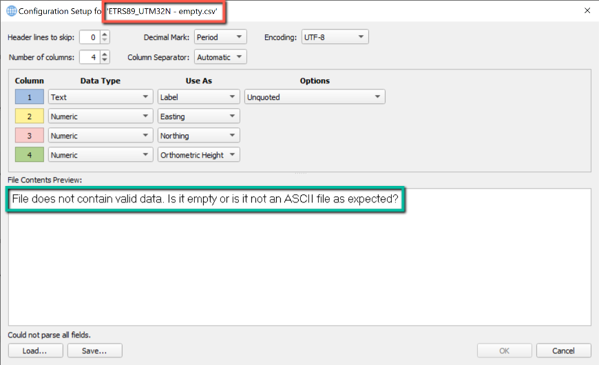
We improved the parsing of text fields used as label when containing only numbers or text and numbers. Error reporting when files cannot be parsed has also been improved
Input of an empty file is now being displayed at BCC wizard page 2 as follows correctly as expected:
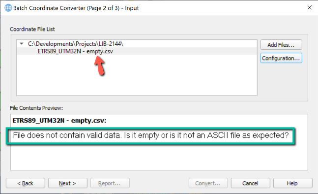
Clicking the Configuration... button shows the following dialog pointing out the selected file does not contain valid data, because it is empty:
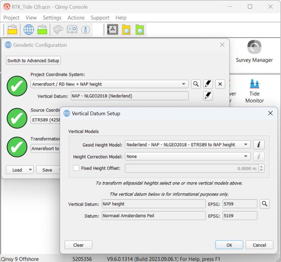
Geo Config - Vertical Datum and its Source Datum
We now prevent you from making setup mistakes with Vertical Datums (Geoid Models).
When you select a vertical datum we would already add the Source Datum related to the selected datum.
If you remove the Source Datum or select a non related Source Datum we will generate a warning
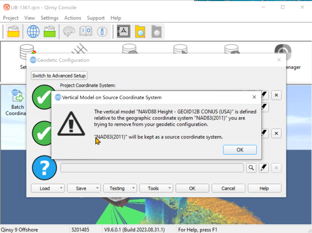
You need to remove/clear or alter the vertical Datum before you can change your source datum
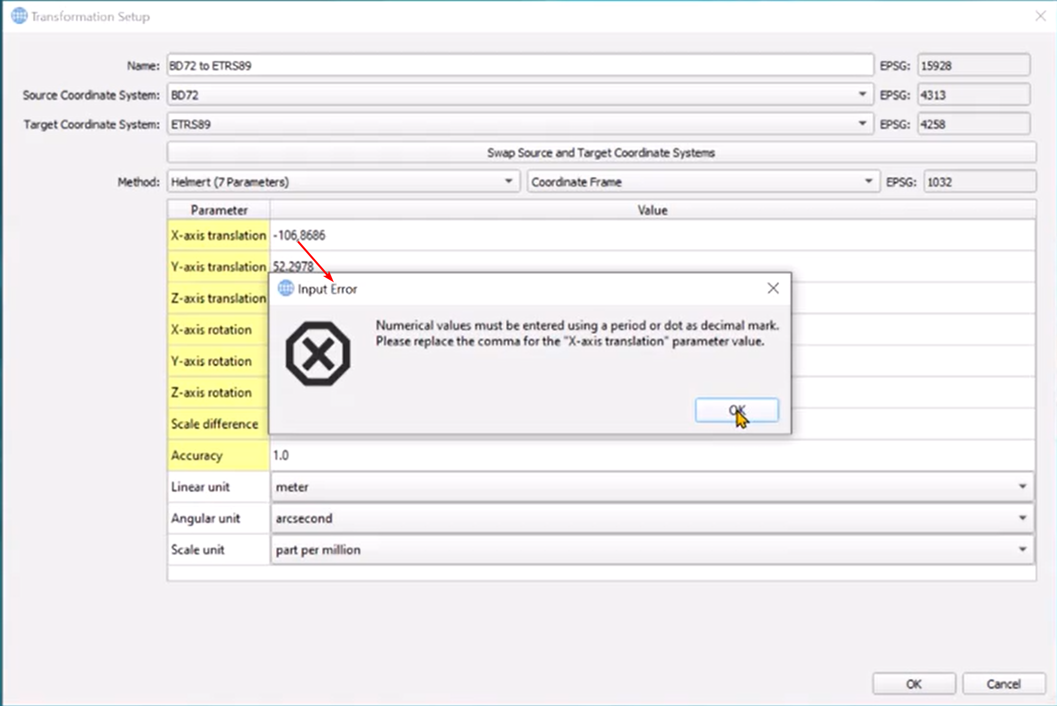
Geo Config - Check on decimal character
When you are entering a the wrong decimal character we will now warn you for it
Setup
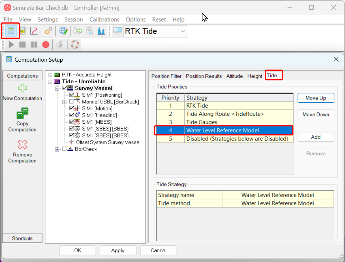
Water Level Reference Model
We renamed the:
-
Mean Water Level Model (MWLM)
to -
Water Level Reference Model (WLRM)
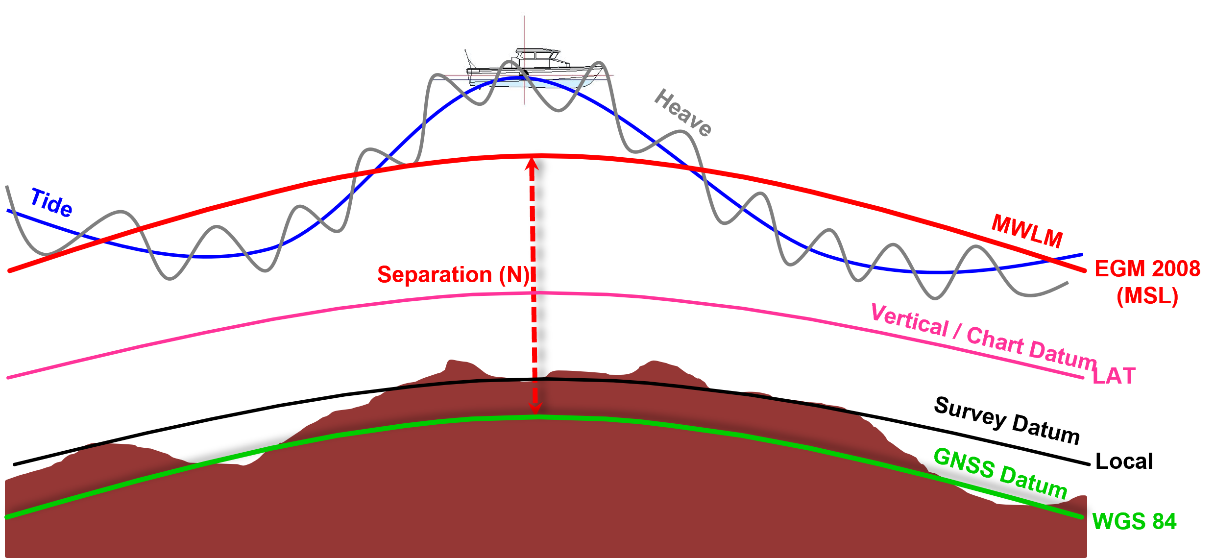
When surveying without and accurate height component (RTK / Total Station) in your position observation, you can use Tide to take care of the height component at your position.
What happens when you only have 2D position and no tide measurement?
In that case you can use a model that represents a water level height to get a better 3D position estimate.
This Water Level Model (WLHM) could represent:
-
Mean Sea Level (MSL),
-
River Low Water Reference (RLWR)
-
Lowest Astronomical Tide (LAT),
-
Mean Low Water Spring (MLWS),
-
ect
Offshore people would generally use GPS or DGPS and did not have tide observations during the survey. Instead they would use a Mean Sea Level Model as a vertical reference.
When surveying with (D)GPS (2D) Qinsy would use the Height from the (MSL) model, together with other height observations, to create a best possible 3D position to perform best possible 3D position transformations.
This system is still used by Qinsy in the background and can be found under the setup of your Template DB:
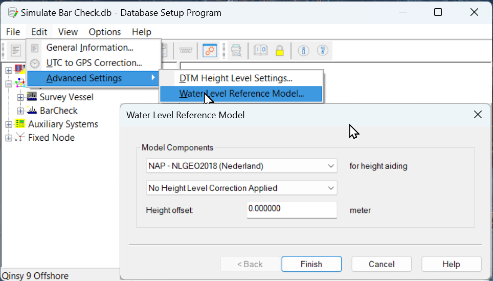
In Qinsy 8 you had to define these settings and it was called the Mean Water Level Model (MWLM).
In Qinsy 9 these settings can still be altered if needed, but they automatically populated with the values from your Geodetic Configuration:
This was done because more and more surveys are done with (pseudo)RTK or Tide from prediction models and would make it easier to setup Qinsy for most users.
Your Chart Datum height level is defined by sum of the Vertical Models.
Generally tide observations are a water level height offsets at a given time (during surveying).
You could see your Chart Datum (CD) as a hide level with 0m tide (water level offset).
Because your Chart Datum (CD) is generally not just a value but represented by a model we renamed the Mean Water Level Model to Water Level Reference Model to make it easier for users to understand what the selection represents under the tide sources.
Drivers
GNSS - Septentrio SBF
Reason for improvement:
When working with a Septentrio in combination with a SBG-INS, both SBG and Qinsy are sending commands to the Septentrio when using the "Network - Septentrio SBF (Binary)" drivers in Qinsy
The "Network - Septentrio SBF (Binary)" drivers send actively commands to the Septentrio to get related data
The Improvement:
We have added 4 new driver entries to allow Qinsy to make connection, but not sending any commands. We added the word “(Passive)” to indicate that we do not send any commands
-
Positioning - "Network - Septentrio SBF (Binary) (Passive)"
-
Motion - "Network - Septentrio SBF (Binary) (Passive) R-P",
-
Heading - "Network - Septentrio SBF (Binary) (Passive) Heading",
-
PPS - "Network - Septentrio SBF (Binary) (Passive)"
INS - Novatel - SPAN - Support BESTGNSSPOS
The existing driver “NovAtel SPAN (#BESTGPSPOS Format)“ is renamed to:
-
“NovAtel SPAN (#BESTGNSSPOS Format)”.
The driver is now autodetecting the format so it doesn’t matter for the driver if the incoming format is #BESTGNSSPOS or #BESTGPSPOS.
Existing template DB’s with the (old) #BESTGPSPOS format will keep on working when going online.
Drivers Manual:
NovAtel SPAN (BESTGNSSPOS Format) (With UTC)
iXblue - TAH
Some of you requested us in the past to add a network driver that would decode the TAH driver without the using the time in the message. We declined that request to prevent users from selecting a driver that could effect their data with variable delays.
We always had the option the create your own user defined network driver for the TAH format, but with the increasing usage of the Attitude Heading Reference Systems (AHRS) like Quadrans in not non survey grate related applications we decided to add driver that will just decode the message and will ignore the time inside the message.
Laser - Riegl
Upgraded to latest SDK v2.6.0
Laser - Z+F / Leica
Upgraded to latest SDK v9.4.1 of Zoller+Frohlich
Sidescan - EdgeTech
We implemented ring buffer support for Sidescan Sonars (SSS) systems to better handle data from systems like the EdgeTech 6205s2
Online
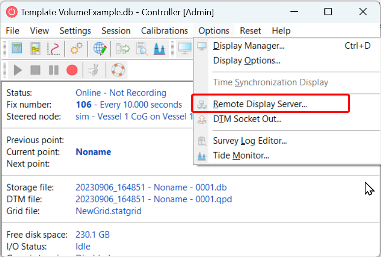
Remote Display Server
Qinsy has the option to show display remotely via the Remote Display Controller:
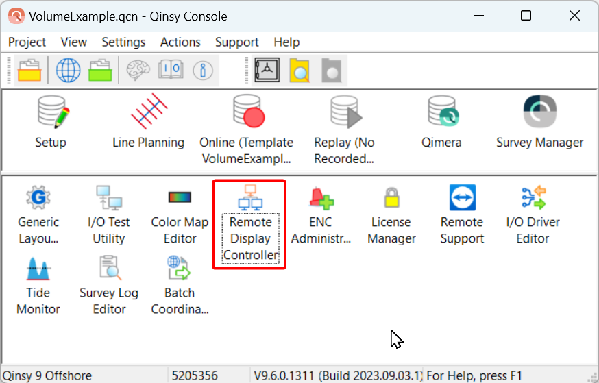
The Remote Display Controller will allow you to setup your own Displays on that PC.
To Supply the Remote Display Controller with information from the Online PC you needed to start the “Socket Server”…..
”Socket Server” has been renamed to “Remote Display Client” to make it easier for users to understand what the option serves:
Documentation and and warnings messages have been updated accordingly
Displays
3D Point Cloud Display - Eye Dome Lighting
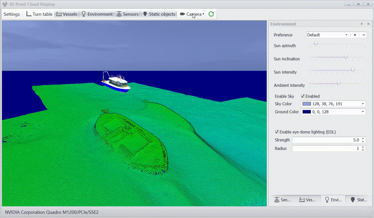
Eye-dome lighting (EDL) option has been added to improve depth perception in the 3D Point Cloud Display.
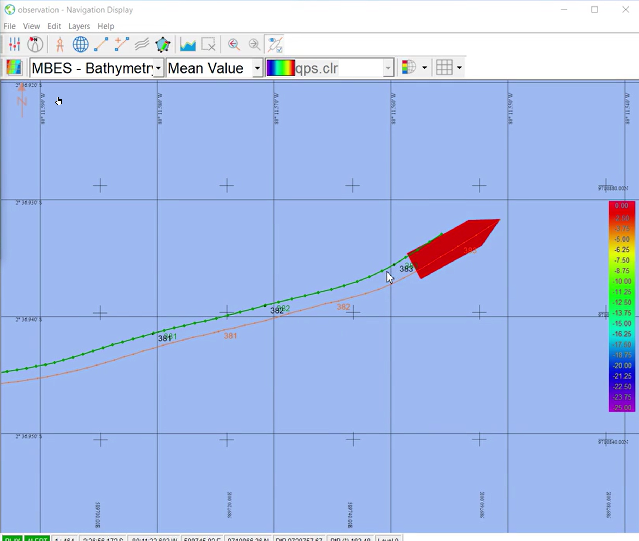
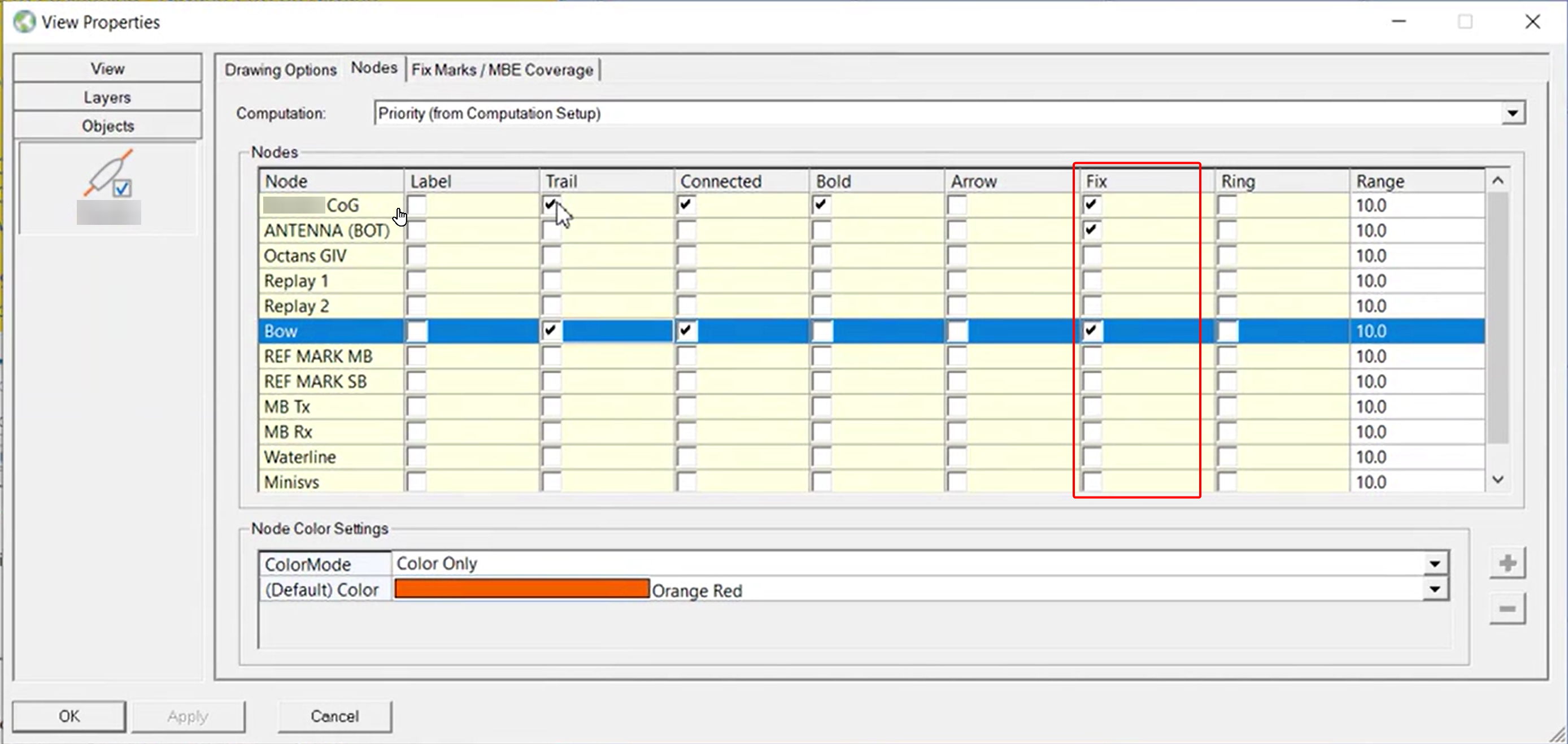
Navigation Display - Object - Fixes per node
You can now select for which nodes you want to display the fixes and the fix labels
Navigation Display - Object Line Thickness
Objects - Option to change line thickness of Vessel Shape:
Survey Manager
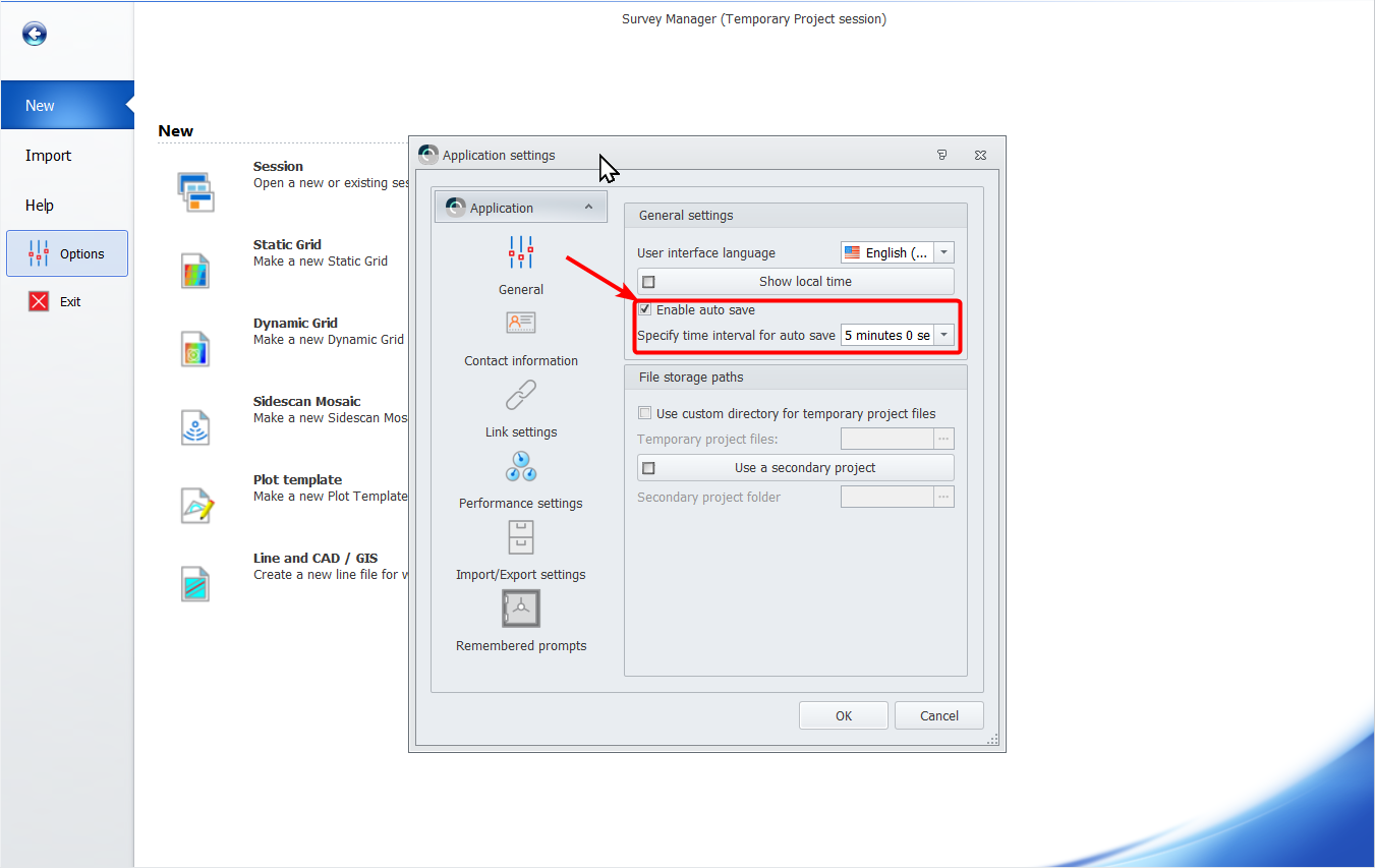
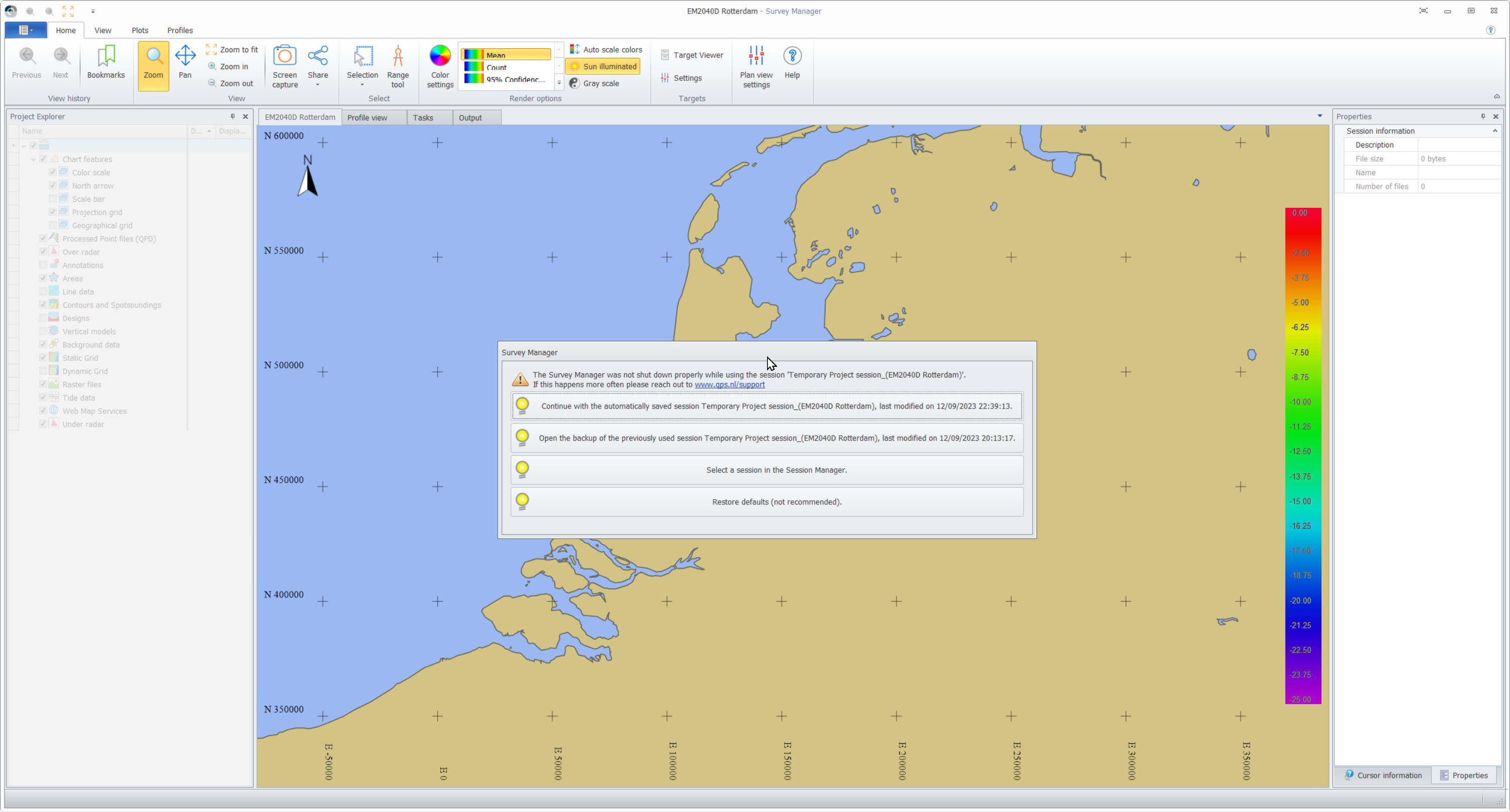
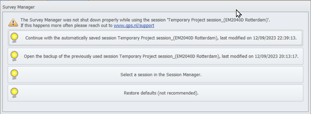
Session - Auto Save and Recovery
Survey Manager has now and autosave option and recovery mechanism in place:
Session - Warning when files are missing
File and Layer Logic
File order and layer logic are now more intuitive and allow you to drag and drop File Type Layers, files within/on a File Type Layers and (grid/cad) layers within files.
Project Explorer
We now allow you drag and drop Files and file type Layers:
This will allow you to better control the draw order of File Type Layers and the draw order of the files on that File Type Layer.
Reordering Grid file order
We now allow you to
-
Reorder Grid Files
-
Drag and drop grid layers
-
Edit Grid Settings and order grid layers
Static Grids - Selected Grid Layer Always On Top
When you select a grid layer we handle this as the active grid layer
The (selected) active grid layer is now always shown on top of all other grid layers:
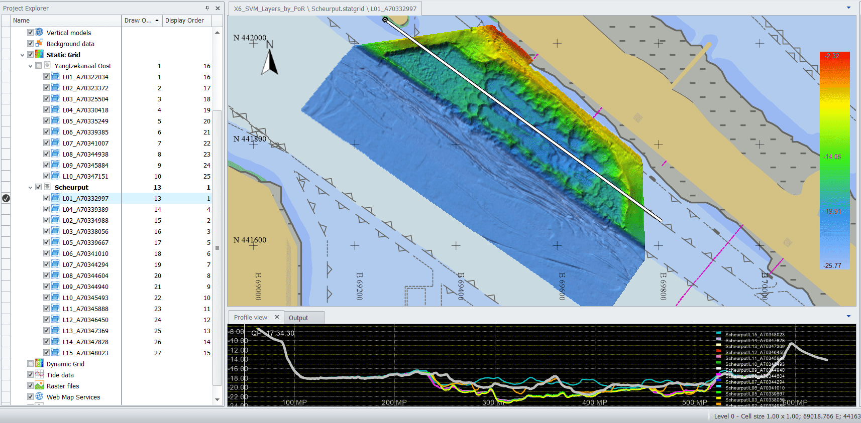
(Data curtesy by Port of Rotterdam)
Static Grids - Draw order versus Display order
To make it possible to give you some insight in how we display items we introduced two columns:
-
Draw Order
-
Display Order
Draw order indicates in which order we draw the layers.
When an grid layer is selected it becomes the active layer. It will maintain its draw order index, but it will be displayed on top. As you can see in the animating GIF above, the selected (active) grid layer maintains its Draw Order index, but I gets Display order index “1”.
File Explorer - File Sorting
You can sort files per file type on:
-
Name (drag and drop layers not possible)
-
Draw order
-
Display order
Range Tool - Undo and Save Route
You can now use the option to undo (Ctrl+Z) route waypoints while you are clicking your route and save it as a route.
Pay attention to the information in the status bar when you are using the Range Tool, as it will reveal more options and how to use them
Raster - GeoTiff - Show additional properties
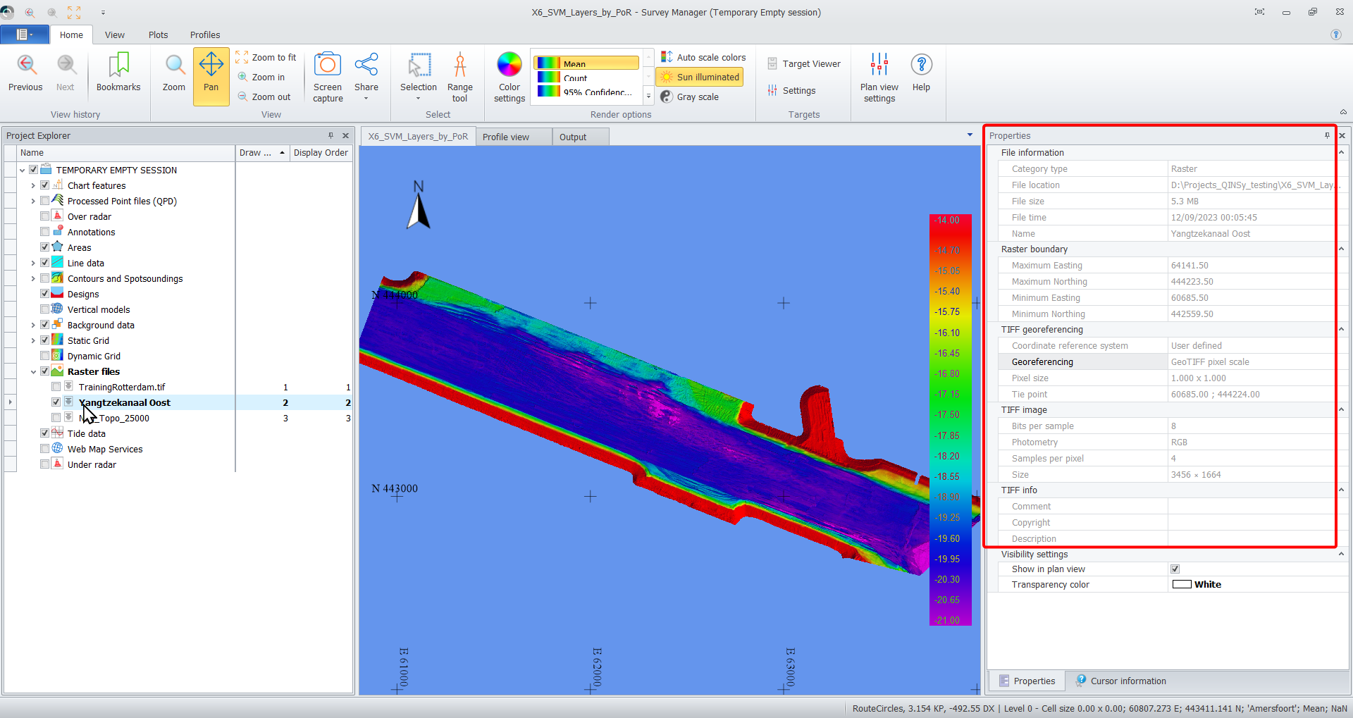
Display additional properties about a GeoTiff file, such as:
Some of the information might come in handy to find out why an image does not end up in its expected location.
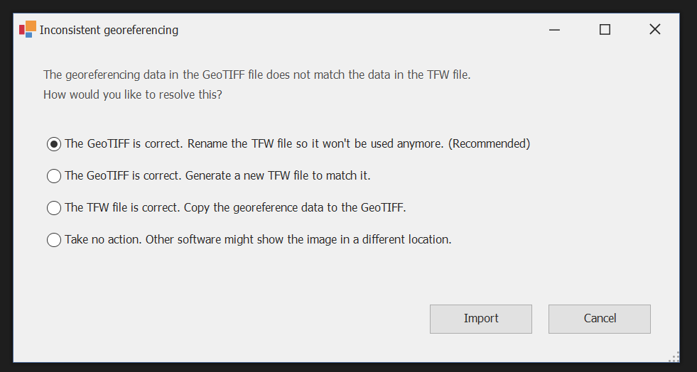
Raster - GeoTiff - Warn if tie point does not match TFW
If a GeoTiff has a tie point defined in its header, and there's also a TFW file available, we check if they contain the same information. If not, a warning shown and offers several options on how to proceed and possibly solve this:
Some background info:
A TFW file is officially called a "world file", but nobody calls it that. It is a format of its own, and it can be a sidecar file for basically anything 2-D you can look at: gif, jpeg, png, Youtube videos, tiff, etc.
People have been pairing it with TIFF for the longest time, but people started asking for advanced GIS capabilities (such as "where is this?") and a new set of fields was added to address this. This specification is, you guessed it, GeoTIFF, and of course it makes no mention of TFW.
So there are two things: TIFF with a TFW, and GeoTIFF. The confusion arises because a GeoTIFF file is also a TIFF file (in the same way that a qgfline is a qgf). And to keep things compatible with old software, a TFW file was provided even with GeoTIFF.
Squire
This is a background process that is used for:
-
Survey Manager
-
Surface Navigation Display
Squire has been updated to use
-
PostgreSQL 15.0
-
.NET 6.0