
On this page:
Voting System Items Implemented
KeyTypeSummaryVotes
Console
Back-up and Restore Tool
Purpose of the Tool
The Backup and Restore tool was created to allow you to make a backup of your project that would allow you to restore it on another identical PC and get back to work ASAP.
This can be useful during a survey when there is an acquisition computer hardware failure, for example.
It can also be used for transferring a prepared projected setup from the office to a vessel encapsulating all needed files that are stored outside of the project location.
This is used sometimes to stage a project in the office prior to going to the field in order to save valuable field time.
Improvements made
Due to a number of recent changes of file types and/or locations, the tool needed to be upgraded.
We have updated the tool to include:
-
Geodetic information
-
User Defined Geoid Models
-
User Defined and previously used Geodetic setups (*.wkt)
-
-
IO Driver Editor (*.ini) files
-
Tide Station XML (used by the Tide Monitoring and Prediction Program)
-
Common project files used by Qinsy, Qimera, Fledermaus and Qarto
-
Color Map files
-
To allow you to back-up your user defined color maps
-
The Color Maps files will be stored in the Project in a folder called "ColorMaps" when Restoring the project on a PC, because not all PCs have user rights that allow the tool to restore them at the installation location.
-
In this situation, you would need to copy the color maps to the installation location "C:\Program Files (x86)\QPS\QINSy\9.3.0\Color Maps" manually with appropriate rights.
-
Drivers
Multibeam in general
We have made fault tolerance improvements in our multibeam acquisition capture, buffering and recording components to prevent corrupted or invalid Intensity Beam Time Series (also known as Snippets, Seabed Imagery) to overflow our data recording buffers.
When a corrupted ping is received, it will now be dropped and will not be stored in the DB file. These events are noted in a log file.
We added additional Alerts for the multibeam observations in the Alert Display.
This all together should prevent many common crashes experienced online with the Multibeamer.exe, Controller.exe, DrvDbOut.exe and Proxy.exe that were caused by the invalid Intensity Beam Time Series.
R2Sonic - TruePix - Raw logging always enabled
Qinsy logs the TruePix as a sidescan system and has the option to log the RAW data packages into the DB file which users can then export to XTF.
Many users indicated that they want to store the RAW TruePix packages when they are logging TruePix.
When they forget to enable the logging of RAW TruePix packages, only the QPS sidescan record can be exported to XTF.
We now always enable the logging of RAW TruePix packages when TruePix is added to the setup: See movie.
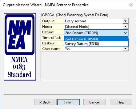
Output - NMEA with GUI - Improve output datum naming
The user interface has been updated to show the actual available datums instead of the hard-coded labels "WGS'84" and "Survey Datum"
Online
Computation - Warning regarding the influence of Accurate Height on used water level
When using an accurate height like RTK in your computations, Qinsy can calculate a water level using the vessel draft, called RTK-Tide.
Qinsy prefers to use the the Water Level from the Accurate height result instead of any available Tide results.
This was not clear to users and therefore we added a warning:
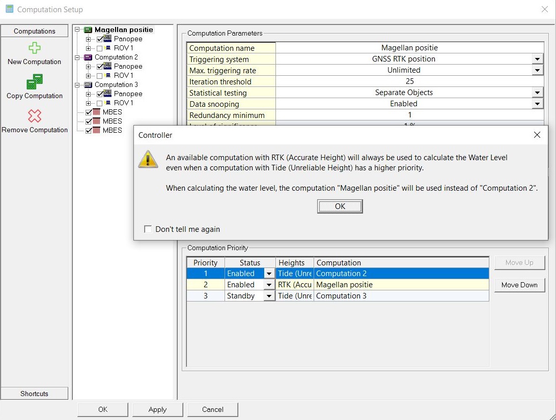
The 'Don't tell me again' checkbox works like every other message box and can be reset by using the Controller - View - Reset 'Don't Tell Again' Flag.
When using an Accurate Height in your computations to calculate the Actual Water Level / RTK-tide, then please read How-to RTK Height as Tide in our Knowledge Base.
Storage - Add parameter to include Sounding Grid name in DB file name
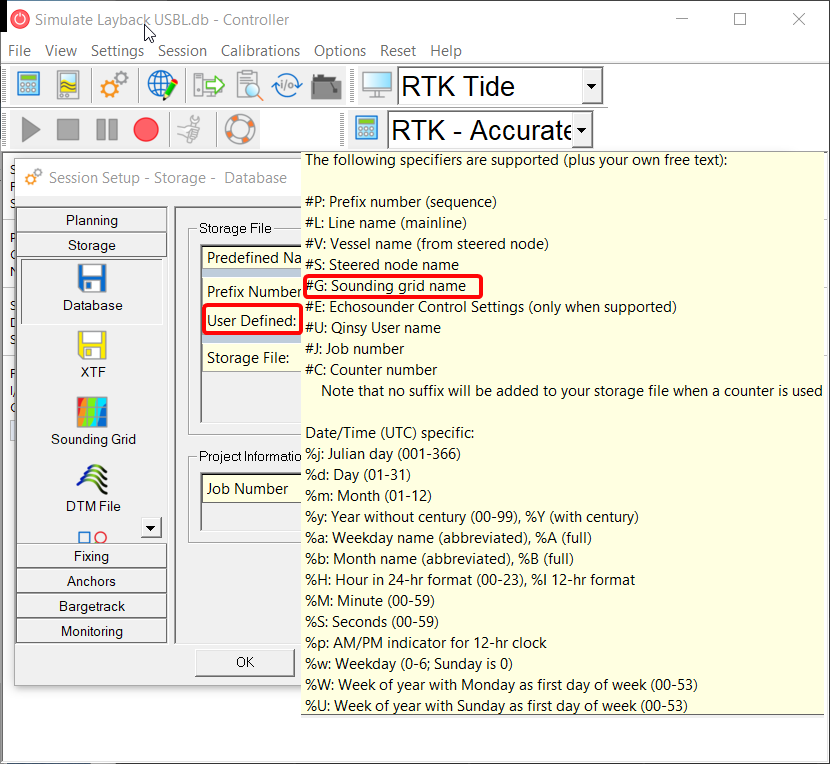
We have added an option to include the name of the Sounding Grid or the Dynamic Surface used during the Online data acquisition into the DB file name.
You may use the following parameters:
-
#G or #G1 (main grid)
-
#G2 (secondary grid)
Survey Manager
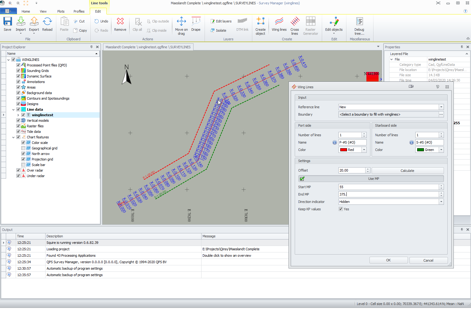
Line Planning - Create Wing Lines using KP values
It is now possible to create Wing Lines between a specified Start and End KP in both the Survey Manager and in the Navigation Display, Online or in Replay:
-
Survey Manager
-
Navigation Display
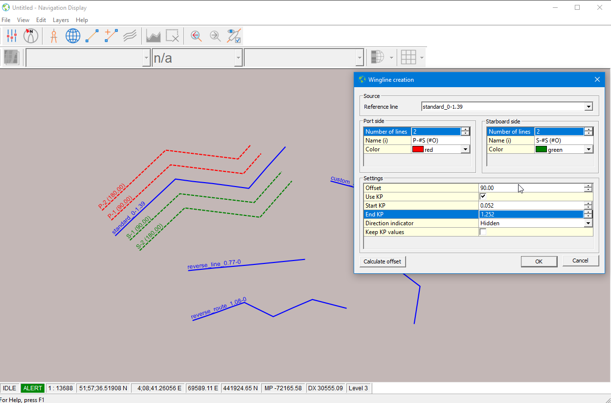
Note:
This wing line generation is meant for As designed/Planned lines and routes.
Should you work with short segments like in an "As Found" pipeline or cable and will be creating wing lines from it, then you might offset the line at such a distance that it will cause the small segments to disappear or intersect with lower KP segments.
This can result in incorrect KP values on the wing lines.
Line Planning - Make preview optional
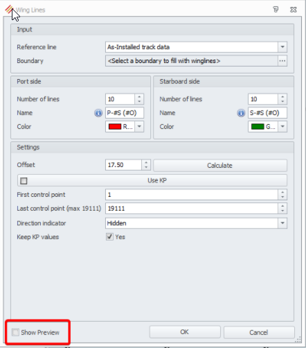
With the introduction of the Preview we received many good responses on the functionality. Unfortunately, some customers were experiencing delays when using 3D routes with more than 19000 segments.
We have made improvements to the algorithm speed for 2D lines and made the Preview optional.
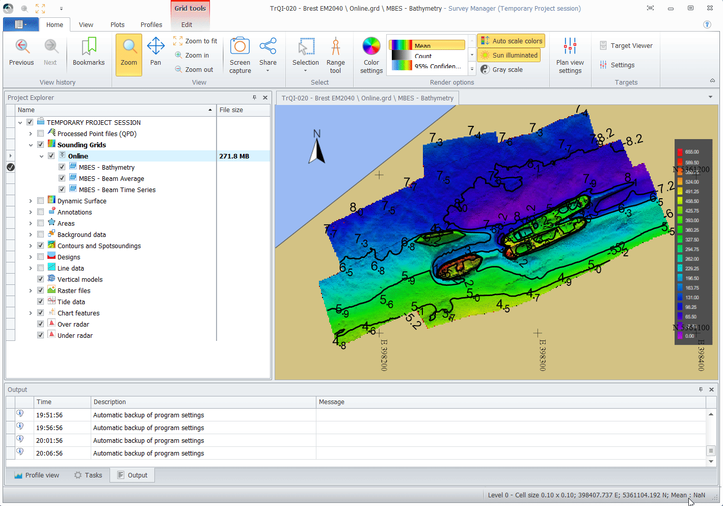
Sounding Grid - Color Map - Option to invert color map
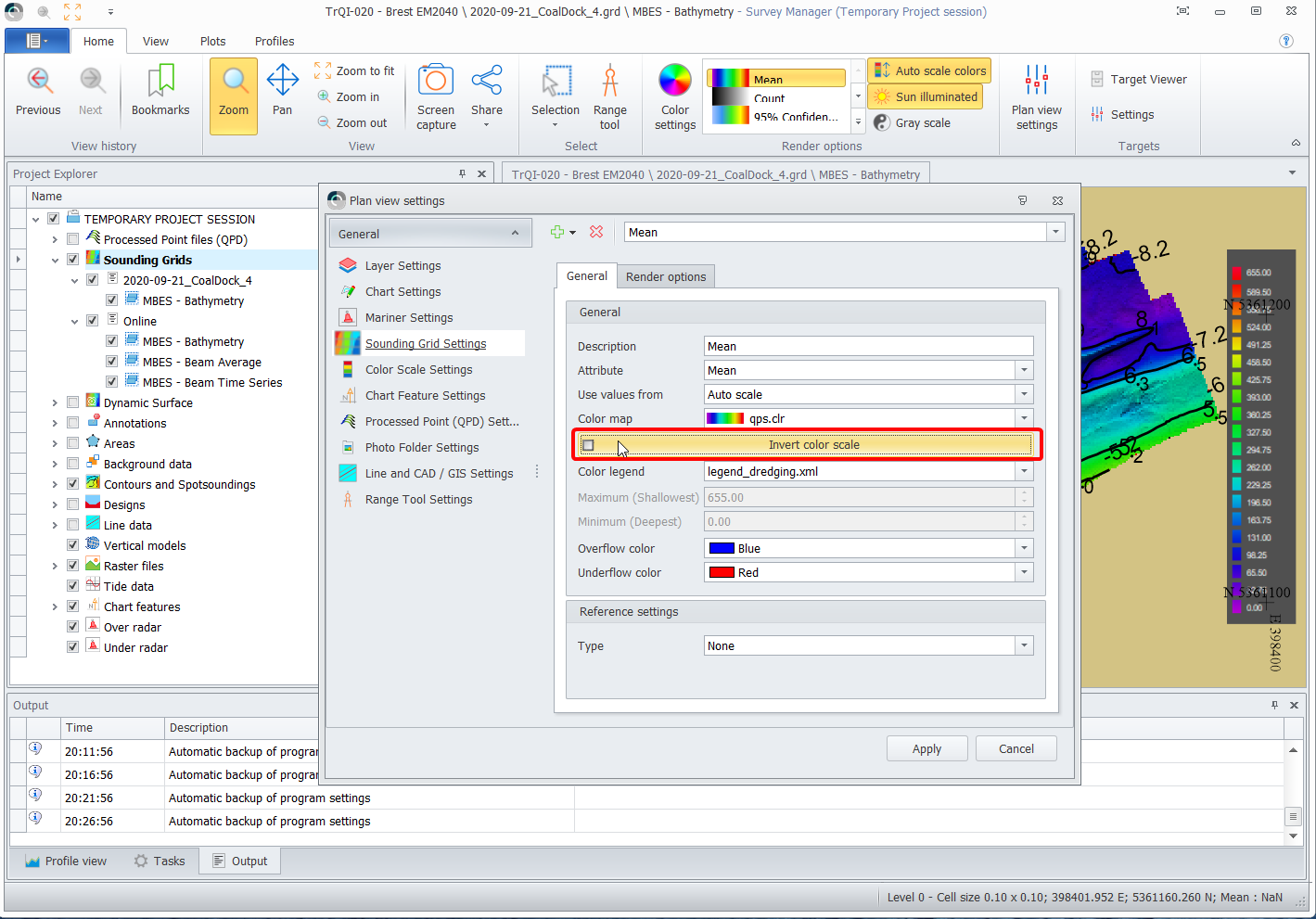
The option to invert color maps has been added.
Sounding Grid - Option to sort layers in alphabetical order
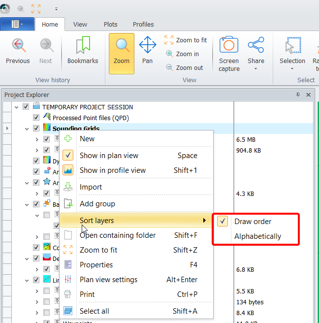
The first time the Survey Manager is started, it will use the order of layer creation (= Draw Order).
When you have enabled the option, all layers in the Sounding Grid and Dynamic Surfaces will be sorted alphabetically. The setting stays active until disabled.
The option is saved as a setting of the Survey Manager.
Sounding Grid - Show file names when creating a new grid
Survey Manager now uses the same 'Creating a new sounding grid' dialog as Online.
The Template DB will be scanned for available system type and are offered in the dialog.
You can now select a previous grid as a base for your grid file name.