
On this page:
Navigation Display
Wingline creation in the Navigation Display
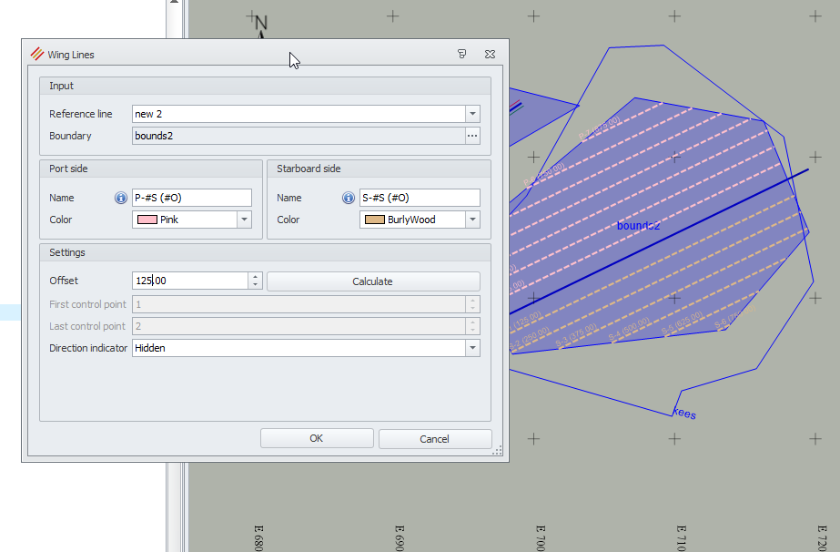
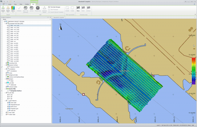
It is now possible to generate winglines in the Navigation Display. When a line or route is selected by clicking on it the color will change to grey to indicate that it is selected.
On this line or route the winglines can be interactively defined. Changing the number of winglines and offset will show a preview of the to be generated lines as is show in this screen capture.
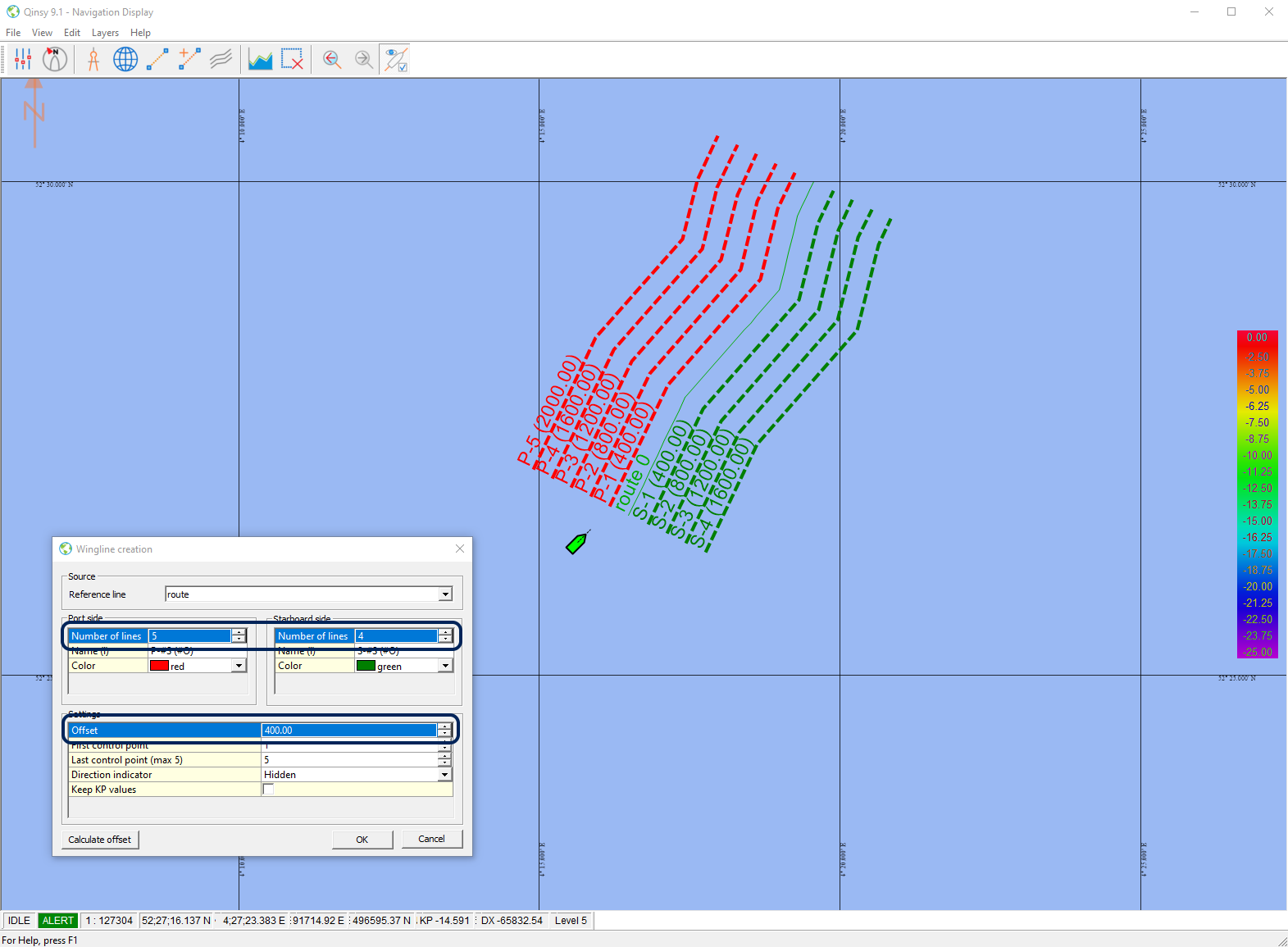
The generated lines are directly added to the survey line selection.
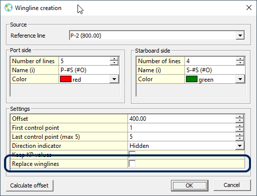
There is an option to replace the generated winglines: select the original line or route again and then in the Wingline creation dialog the option 'Replace winglines' becomes available.
Tips for using the Wingline creation:
The wingline creation can also be used to quickly create a single new line at an offset to the previous line.
Set the number of lines to 1, click the current surveyline and change the offset as needed. This can be done during recording.
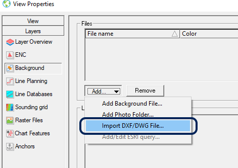
DXF/DWG import in the Navigation Display
A new option to import a DXF/DWG File in the Navigation Display.
The import will do a silent conversion to a background file (*.qgfback) and will immediately select the file for displaying.
The DXF/DWG will be moved to backup folder < project >/ Line data / Backup.
3D Grid Display supports Dynamic surfaces
Dynamic surfaces are now supported in the 3D Grid Display. The grid data can be selected and shown.
Patch test
Qimera patch test available for Qinsy users
More information in the Qimera 2.1 Release notes.
It is now possible for Qinsy 9 users to use the patch test functionality of Qimera WITHOUT a Qimera license. It is only necessary that Qimera version 2.1 is installed next to Qinsy 9.1 (previous versions will not work).
This provides and alternate workflow to using the patch test functionality in Validator.
Select the QPD files in the Survey Manager and use the Patch Test (Qimera) option that appears next to the Validator.
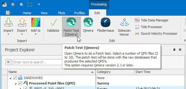
When running in 'Patch Test' mode, the user interface of Qimera will simplify to only show the portions of the application that are necessary for calibration.
Read more about the patch test functionality in the Qimera 2.1 Release notes.
The following notes on this functionality:
-
The patch test requires the creation of QPD files while online, in the same way as when using the Validator
-
The resulting patch test offsets are written back to the template.db file(s), and these will be used during further data collection. Already recorded database files cannot be updated.
-
Users with a full Qimera or a Qimera Clean license will still be able to access their functionality by starting Qimera in the usual way.
-
It is not necessary to contact QPS for a license, just download and install Qimera 2.1
Online
Area Based Auto-Recording Method
A new automatic recording option has been added that is Area based .
The start, stop and/or pause recording events will be fully based on whether the current steered node position is inside or outside one or more selected areas.
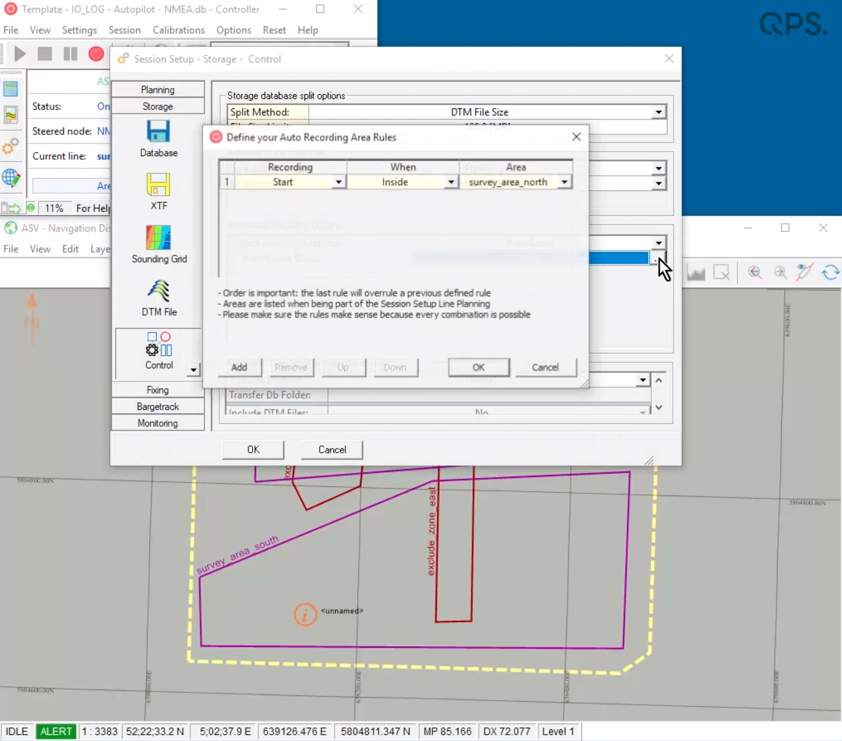
These areas can be:
-
A Route from a line data file as defined in the Survey Manager under Line data or from Waypoint Planning in the Navigation Display (*.qgfline).
-
A real Area as defined in the Survey Manager under Areas (*.qgfarea).
-
An Annotation Area as defined in the Survey Manager under Annotations or when adding an Annotation area in the Navigation Display (*.qgfanno).
Selected areas will automatically become visible in the Navigation Display with an indication that they are being used for auto recording
FQI-242 - Online - Session Setup - Storage - Control - Auto-Recording Method - Area Based
Online storage of data to a second grid
It is now possible to record data to two grids at the same time:
-
The grid storage page now has 2 tabs so that two grids can be set up
-
The information area in the Controller shows the selected grids in one row
-
Only the main grid is visible in the Navigation Display
-
You can only have 1 Dynamic Surface active (does not matter which tab)
-
Selecting the same grid in each tab is not possible. When attempting to use the same grid twice a warning will pop up.
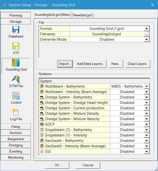
Example usage what can be stored at the same time:
-
(Static) Sounding Grid 0.1x0.1m including:
-
Sidescan Sonar
-
MBES Bathymetry (needed for shading/draping of the SSS data)
-
-
Dynamic Surface (to go directly to Qimera) 1x1m
Details can be found here:
FQI-257 - Online - Storage - Sounding Grid - Multiple Grids / Grid per system type
Showing multiple grids in the Navigation Display is not part of this development see a related item:
FQI-662 - Displays - Navigation - Option to show Additional Terrains of the type Sounding Grid
Survey Manager
Wingline creation in Survey Manager
The dialog has been made very similar to the wingline creation in the Navigation Display and also the functionality has been made similar so that previously created lines can be replaced.
In addition in this dialog it is possible to select a clipping boundary, previously created in the Areas folder.
Survey Manager - Create a QR code to open Squire on browser
The project view can now be shown in a browser, by scanning a QR Code or by clicking the link.
This is an easy way to view a project on a tablet or phone, without the need to install Qinsy on that device. The only requirement is that both devices are on the same network.
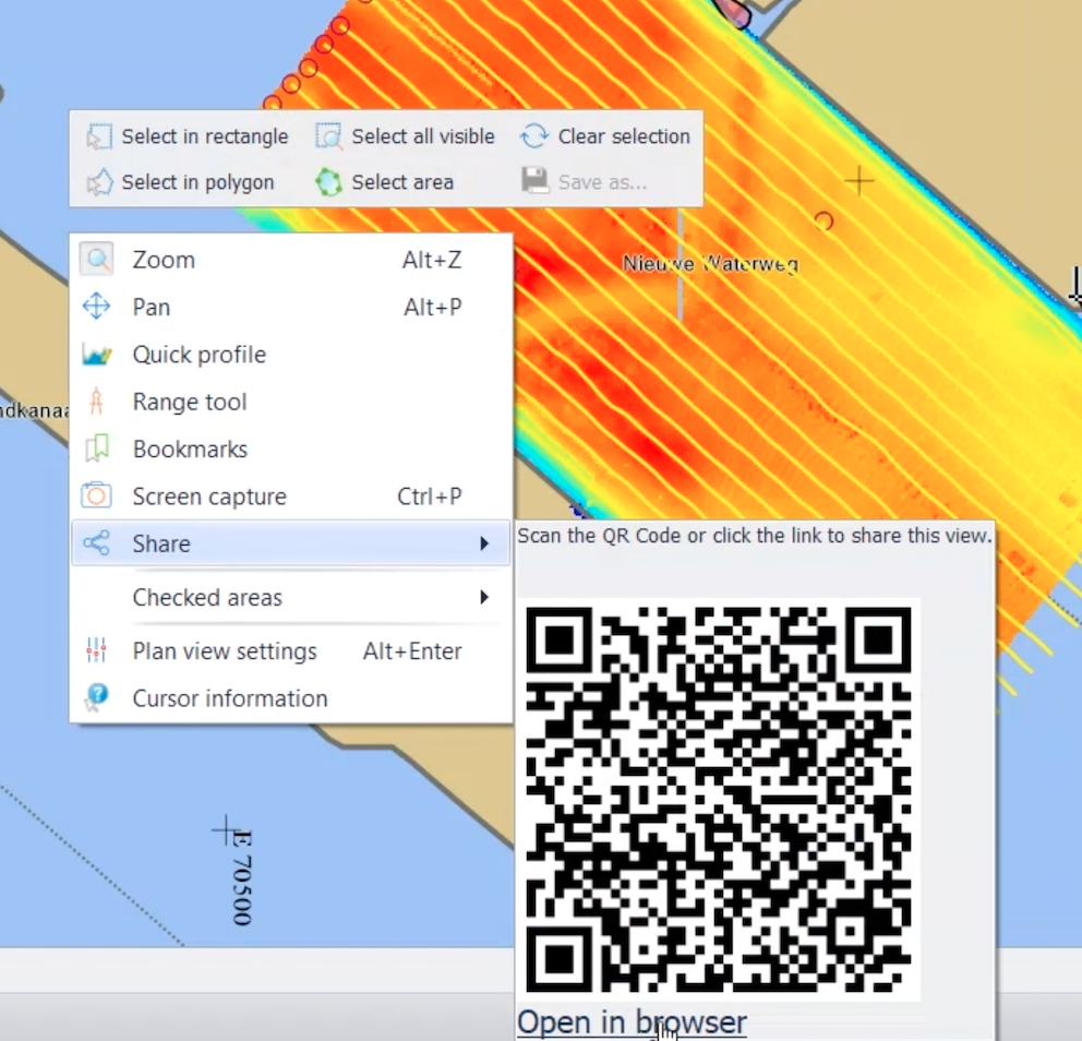
The screen above shows a short movie
Drivers
Drivers - MBES - Imagenex - Add support for Imagenex D1P format
A driver for decoding multibeam data from a Imagenex unit that outputs in the D1P format has been added
FQI-299 Drivers - MBES - Imagenex - Add support for Imagenex D1P format