Height Aiding Results are not available for Export
Parent Item
Vessel:
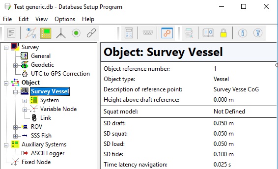
The first entry is always [Reference Vessel] This means that the first defined object will be used (with Object Id 1). In Database Setup you will see a 'square' icon in front of the vessel name:
The rest of the list will show all available objects, existing in the current selected Qinsy database (seeGeneral Layout Information about loading a Qinsy database).
Sub Item
Value Type
Comment
User-defined free text
text
Text Format
Normal Text Your own free plain text
Binary Enter one or more ASCII character codes, comma or space separated, in the range between 1 and 127. For example '2' for a binary STX character, '3' for a binary ETX character, or '13, 10' for CR+LF. See tableASCII Codes for an overview of all possible characters.
New Line Same as Binary but already formatted as '13, 10' (meaning CR+LF) and without a possible Field Delimiter. A Field Delimiter may be present when your layout purpose is for Export or ASCII Logging.
Time
Update time (UTC) of the height aided observation
time
Vessel Name
Name of the vessel (object), as entered in Database Setup
text
Height
Value [in survey units] of the Height Aided Observation, which is calculated by the Height Aiding driver. Driver is always present in the Windows task-bar.
The Height value is by default on Chart Datum (also known as Vertical Datum), but Survey Datum or WGS84 may be selected.
Note that this value is the same as the height of the reference node for the selected vessel.
double
Datum:
Survey Datum Height value will be on the selected survey datum ellipsoid, e.g. ED50. Survey Datum (or Horizontal Datum) is set in the Geodetic Configuration as Project CRS.
WGS84 Height value on the WGS'84 datum. Notice that WGS84 (or ITRF2008) must be one of the two selected CRS's in the Geodetic Configuration.
Chart Datum (default) Height value on the selected vertical datum e.g NAP, De Min Geoid. Chart Datum (or Vertical Datum) is set in the Geodetic configuration as Vertical CRS.
Height Status
Two possible values: one or zero.
0: The height aided observation is not used in any of the computations: The height status of the triggering system (located on the selected vessel) is set to Accurate in all available computations.
1: The height aided observation is used in at least one of the computations. I.e. that the height status of the triggering system (located on the selected vessel) is set to Unreliable in one of the computations.
int
Height Sd
1 Sigma (68%) A-Priori Standard deviation of the Height Aiding observation
double
Heave
Heave component of the Height Aided Observation.
double
Heave Status
Two possible values: 1: Heavecomponent is part of the height aided observation 0: No heave component, or no height aided observation at all
int
Squat
Squat component of the Height Aided Observation.
double
Squat Status
Two possible values: 1: Squat component is part of the height aided observation 0: No squat component, or no height aided observation at all
int
Draft
Draft component of the Height Aided Observation.
double
Draft Status
Two possible values: 1: Draft component is part of the height aided observation 0: No draft component, or no height aided observation at all
int
Tide
Tide component of the Height Aided Observation.
Notice that this item is the same as item Tide under Tide Results
double
Tide Status
Two possible values: 1: Tide component is part of the height aided observation 0: No tide component, or no height aided observation at all
Notice that this item is the same as item Tide Status under Tide Results
int
MWL Model
Mean Water Level Model component (often known as Mean Sea Level) of the Height Aided Observation.
double
MWL Model Status
Two possible values: 1: MWL (Mean Water Level) Model component is part of the height aided observation 0: No MWL Model defined (in Db Setup), or no height aided observation at all
int
Depth
ROV Depth component of the Height Aided Observation.
double
Depth Status
Two possible values: 1: ROV Depth component is part of the height aided observation 0: No depth component, or no height aided observation at all
int
Actual Water Level
The actual water level above Survey Datum
For the object's reference node the "Height above Actual Water level" value is used minus the "Height above Survey/WGS84/Chart Datum" value.
double
Datum:
Survey Datum Height value will be on the selected survey datum ellipsoid, e.g ED50. Survey datum (or Horizontal Datum) is set in the Geodetic Configuration as Project CRS.
WGS84 Height value on the WGS'84 datum. Notice that WGS84 (or ITRF2008) must be one of the two selected CRS's in the Geodetic Configuration.
Chart Datum (default) Height value on the selected vertical datum e.g NAP, De Min Geoide. Chart Datum (or Vertical Datum) is set in the Geodetic configuration as Vertical CRS.
Mean Actual Water Level
The Actual Water Level (see above) minusthe heave of the object, so i.e. the actual water level without the swell influence.
double
Datum:
Survey Datum Height value will be on the selected survey datum ellipsoid, e.g ED50. Survey datum (or Horizontal Datum) is set in the Geodetic Configuration as Project CRS.
WGS84 Height value on the WGS'84 datum. Notice that WGS84 (or ITRF2008) must be one of the two selected CRS's in the Geodetic Configuration.
Chart Datum (default) Height value on the selected vertical datum e.g NAP, De Min Geoide. Chart Datum (or Vertical Datum) is set in the Geodetic configuration as Vertical CRS.
Mean Water Level
The Actual Water Level (see above) minusthe heave of the object (swell) and minus the tide.
double
Datum:
Survey Datum Height value will be on the selected survey datum ellipsoid, e.g ED50. Survey datum (or Horizontal Datum) is set in the Geodetic Configuration as Project CRS.
WGS84 Height value on the WGS'84 datum. Notice that WGS84 (or ITRF2008) must be one of the two selected CRS's in the Geodetic Configuration.
Chart Datum (default) Height value on the selected vertical datum e.g NAP, De Min Geoide. Chart Datum (or Vertical Datum) is set in the Geodetic configuration as Vertical CRS.
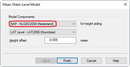
MWL Geoid Height
The current geoid height above survey datum. This is the calculated height value for the vessel location from the Mean Water Level model. This model is selected in the database setup, Edit menu, Advanced settings, Mean Water Level Model:
double
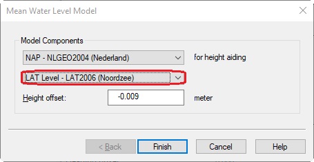
MWL Level Height
The current level height above geoid datum.
This is the calculated height value for the vessel location from the Mean Water Level model. This model is selected in the database setup, Edit menu, Advanced settings, Mean Water Level Model, using the second drop-down list selection. Normally you select here your River Lines model.
double
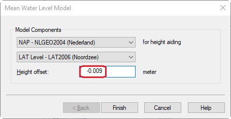
MWL Height Offset
The height offset above level datum. This is a fixed offset value as entered in the database setup, Edit menu, Advanced settings, Mean Water Level Model.
Note that this item is actually the same as item "MWL Model Height Offset" in group SETUP DATA, category Geodetics.
double
JavaScript errors detected
Please note, these errors can depend on your browser setup.
If this problem persists, please contact our support.