DTU Mean Sea Surface Models
On this page:
DTU
Danmarks Tekniske Universitet (DTU) is the Technical University of Denmark, located in a northern suburb of Copenhagen. Part of the DTU is the National Space Institute (DTU Space) with five research divisions and two DTU centres, including Geodesy and Earth Observation (GEO). One of the research results from satellite radar altimetry missions are the so-called DTU Mean Sea Surface models, updated every couple of years.
Geoid
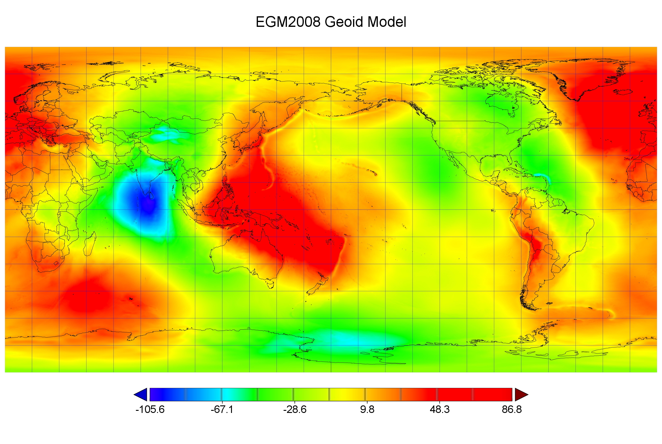
The marine geoid, also called Mean Sea Level (MSL) in QPS software, is the shape of the sea surface without perturbing forces such as tides, currents and wind. The geoid is an equipotential surface that reflects the Earth’s gravitational field and varies in height between minus 110 and plus 90 meters (with respect to a reference ellipsoid such as WGS84) over distances of several thousand kilometers due to uneven mass distribution within the Earth’s crust, mantle and core. Other, less pronounced irregularities are also visible over smaller distances. These reflect the ocean bottom topography.
Geoid models will only be updated when more (and more accurate) gravitational data becomes available.
Relation Geoid MSS MDT
Geoid = Mean Sea Surface (MSS) - Mean Dynamic Topography (MDT)

Mean Sea Surface
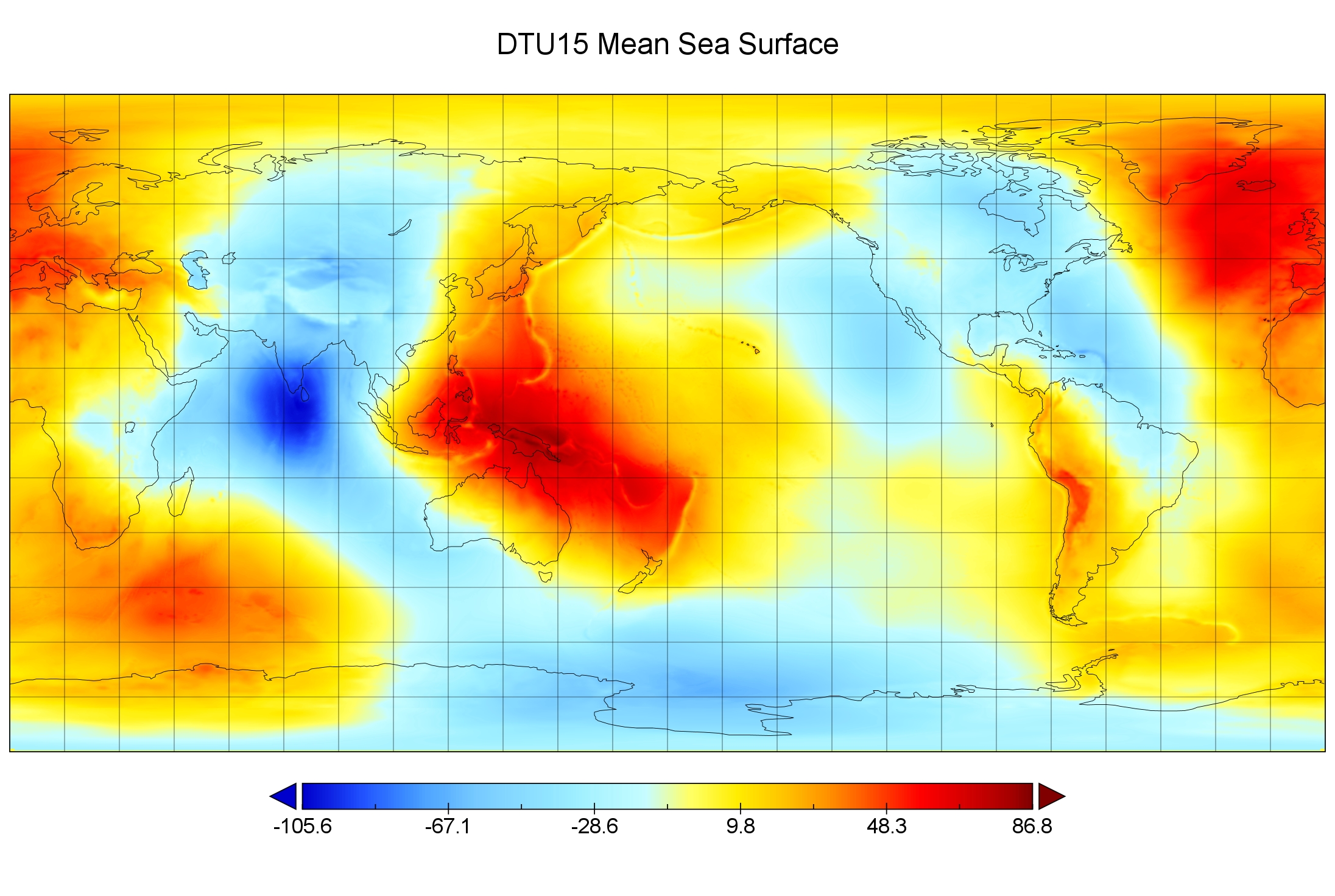
The Mean Sea Surface (MSS) represents the sea level due to constant phenomena such as ocean circulation, currents and wind. It is the sum of the marine geoid and the Mean Dynamic Topography (MDT) that includes the permanent stationary component of ocean dynamic topography. So MSS models are not geoid models! The MSS is not computed from gravity data, but from satellite radar altimetry measurements, averaging data (from several satellite missions) over several years. MSS heights are in the same order of magnitude as the geoid heights. The instantaneous Sea Surface or ocean topography with respect to the reference elllipsoid is called the Sea Surface Height (SSH) and is most obviously affected by tides and seasonal cycle changes.
MSS models will not only be updated because more (and more accurate) altimetry data becomes available, but also if ocean circulation, currents and wind patterns change, for example because of climate change.
Relation Geoid MSS MDT
Mean Sea Surface (MSS) = Geoid + Mean Dynamic Topography (MDT)

Mean Dynamic Topography
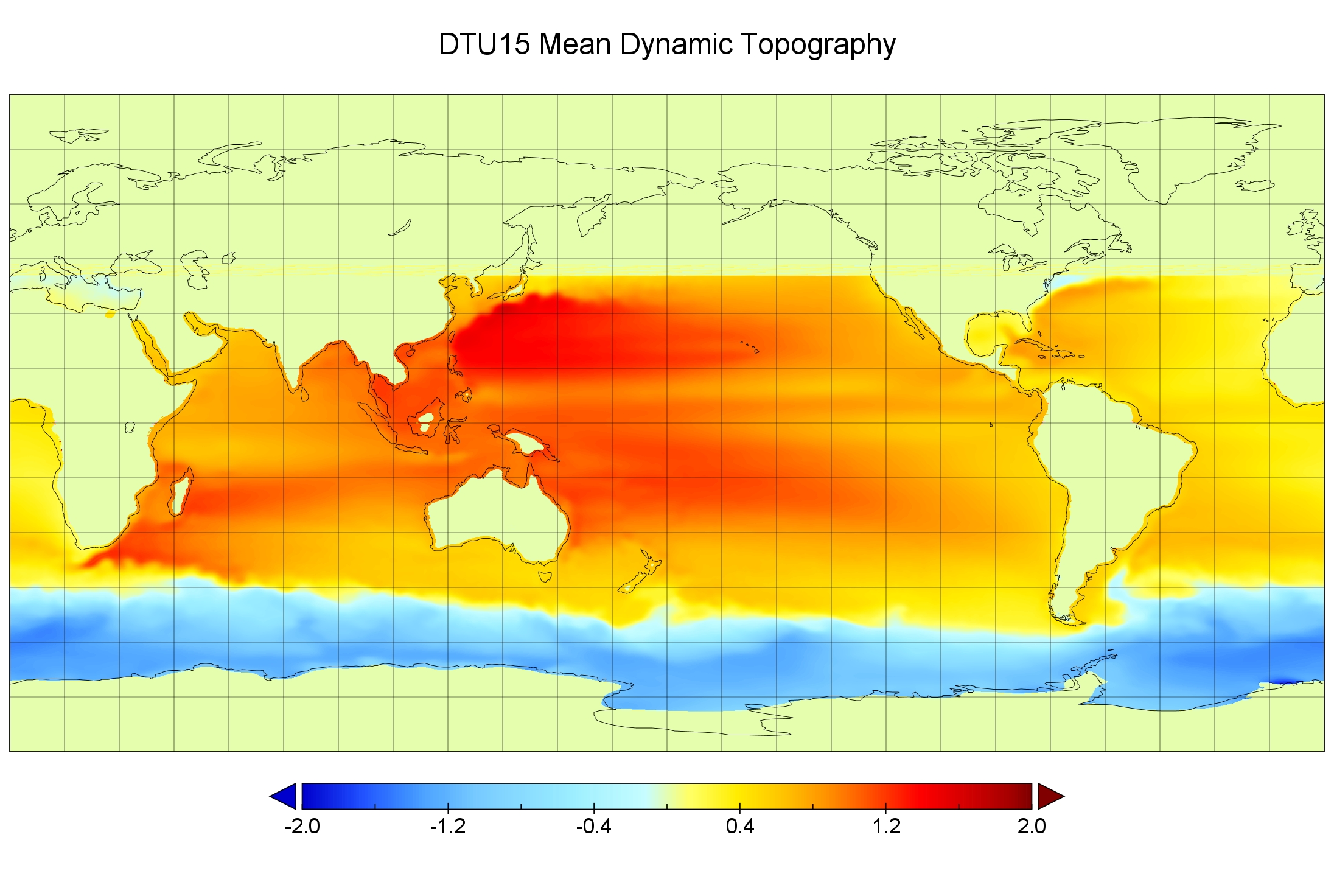
The Mean Dynamic Topography (MDT) is the permanent stationary component of ocean dynamic topography, the sea level driven by thermodynamic processes in the ocean: currents, surface wind, gradients in temperature and salinity, local river/ice-melt flow from land. This mean circulation is not produced directly from altimetry data, but by combining altimetry data with other data (in-situ, gravimetric satellites, etc), to determine the marine geoid precisely, and by subtracting it, compute the mean circulation. MDT heights vary between minus 1.5 and plus 1.5 meters. The instantaneous sea surface or ocean topography with respect to the geoid is called the Absolute Dynamic Topography (ADT) and is sometimes called Sea Surface Topography (SST). Differences between ADT and MDT are called Sea Level Anomalies (SLA) or Sea Surface Height Anomalies (SSHA).
Relation Geoid MSS MDT
Mean Dynamic Topography (MDT) = Mean Sea Surface (MSS) - Geoid

Tide Systems
MSS models from satellite altimetry are usually defined relative to the mean tide system, whereas geoid models are in practice almost always defined relative to the tide free system. When computing an ocean Mean Dynamic Topography (MDT), the MSS and the geoid first have to be computed in the same system. If not, the impact on the resulting MDT is large.
Users must be aware of this. If hydrographic surveys using MSS models are compared with each other, or with surveys performed using a geoid model as vertical reference, then differences in tide systems must be taken into account. These differences vary from +/- 26 cm at the poles to +/- 13 cm at the equator. See Permanent Tide Systems for more information.
Tide Level
Tide heights are referenced to some tide level that is usually connected to a bench mark at the coast or on land. Geoid model heights are also often connected to a bench mark at the coast or on land. So a zero tide height level can often be represented by a geoid model. Mean Sea Surface height are always given on a datum ellipsoid. As explained above, it is not an equipotential surface but a surface that includes the mean dynamic topography due to ocean circulation and such.
Users must be aware of this. They must know (and select) the vertical model that corresponds to their zero tide height level. If that level is better represented by a geoid model than an MSS model, then selecting an MSS model will introduce a delta height error equal to the (difference in) mean dynamic topography.
File Format
DTU MSS model files are available in both the binary NetCDF format (*.nc) and ASCII grid format (*.mss).
NetCDF (Network Common Data Form) is a set of software libraries and self-describing, machine-independent data formats that support the creation, access, and sharing of array-oriented scientific data. The project homepage is hosted by the Unidata program at the University Corporation for Atmospheric Research (UCAR). They are also the chief source of netCDF software, standards development, updates, etc. The format is an open standard. NetCDF Classic and 64-bit Offset Format are an international standard of the Open Geospatial Consortium. NetCDF files contain a header which describes the layout of the rest of the file, in particular the data arrays, as well as arbitrary file metadata in the form of name/value attributes. The format is platform independent, with issues such as endianness being addressed in the software libraries. The images above have been created using the Panoply NetCDF Data Viewer from NASA's Goddard Institute for Space Studies.
Since QPS is currently in the progress of updating the NetCDF third-party library, the ASCII data files for the various DTU MSS models (*.mss) have been converted to the binary grid format used for geoid models (*.bin).
Sources
- Radar Altimetry Tutorial and Toolbox > 5.2.2.5 Reference surfaces
- NGA - Office of Geomatics - EGM2008 2.5 Minute Interpolation Grid
- DTU Space - Geodesy and Earth Observation - DTU15 1 Minute Grids
- UCAR - Unidata Program Center - Network Common Data Form (NetCDF)
- NASA - Goddard Institute for Space Studies - Panoply NetCDF Data Viewer
