
How-to Geophysical Survey
Qinsy is primarily employed to compute positions of geophysical sensors, store raw data from various sensors, and visualize data online.
On this page:
Overview
There are many methods and types of instrumentation used in geophysical surveys.
Qinsy supports positioning data acquisition for:
- Marine seismic surveys, such as 2D and 3D towed streamer, ocean bottom cable, and vertical seismic profiling
- Sub-bottom profiling (a sub-category of seismic surveys)
- Magnetometer surveys
- Side scan surveys
Note
It is important to understand that Qinsy is primarily employed to compute position of geophysical sensors, store raw data from various sensors, and visualize data online.
There is some side scan processing capability in the Survey Manager but, in the main, geophysical data processing is done in Fledermaus and Qimera.
Marine seismic
Info
Some of the material presented here is courtesy of the International Association of Oil & Gas Producers, whose Report No: 448 "An Overview of Marine Seismic Operations" provides invaluable information and is recommended reading.
All geophysical surveys utilize one or more sound sources (e.g. airgun) and some configuration of receivers or sensors (e.g. hydrophone) that measure the energy level of reflected sound waves. Surveys may be differentiated on the basis of:
- The geometry of the receiver system
- The density of measurements made over a given area
- The type of sensor used
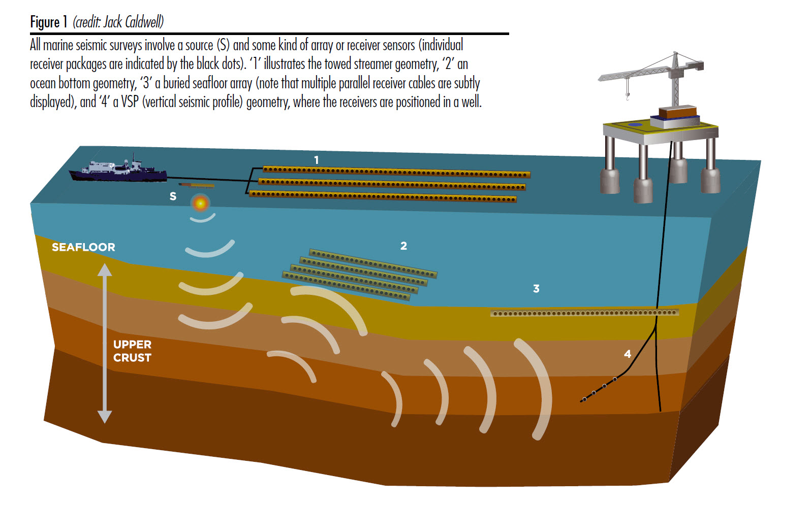
Figure 1 illustrates the different receiver geometries used in marine seismic surveying, while Figure 2 provides a list of the different types of surveys. Receiver sensors are typically housed in cables of varying length depending on the depth of the geophysical target being investigated. Towed cable operations are the most common, followed by ocean bottom seismic where cables can either lie on the seafloor surface or be shallowly buried. Shallow water/transition zone seismic is undertaken in shallow water such as tidal zones, river estuaries, marshes and swamp lands. Vertical seismic profiling is an additional category of seismic survey where the receivers are placed in one or more well holes and a source is hung off the well platform, or deployed using a source vessel.
The density of the measurements made over a given area differentiates 2D surveys from 3D and 4D (time-lapse surveys). 3D surveys employ multiple cables and often multiple sources. They have a much denser number of measurements than 2D surveys which employ a single source and single cable. In general 4D (time-lapse surveys) data density per unit area is higher than 3D.
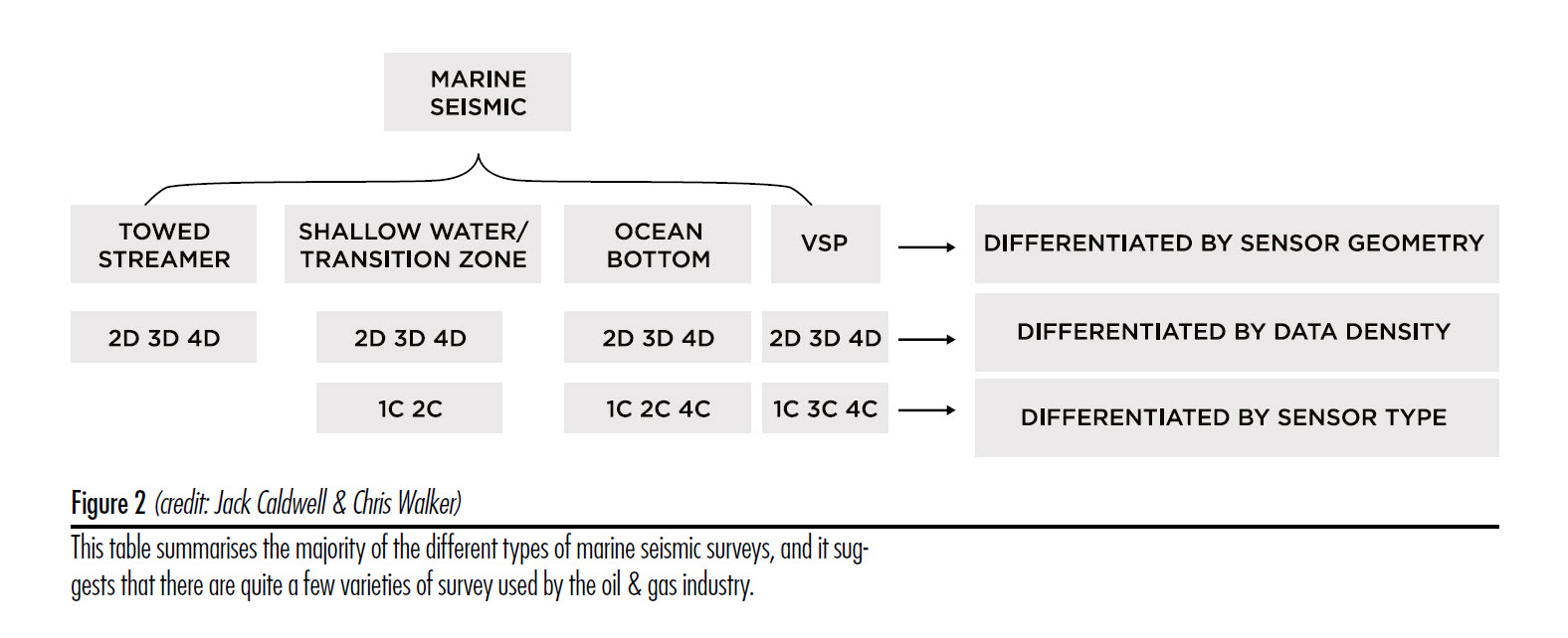
The type of sensor employed further differentiates survey types. In most marine surveys the sensor is a hydrophone that detects the pressure fluctuations in the water caused by the reflected sound waves originating with a sound source. In towed cable operations the neutrally buoyant cable(s) containing the hydrophones is towed, or 'streamed' behind a moving vessel. The number of 'streamers' towed can be up to 12 or more (e.g. PGS Ramform vessels accommodate up to 22 streamers). Streamers can be very long, even up to 12 or more kilometers depending on the depth of the geophysical target being investigated. In ocean bottom surveys each receiver contained in the cable typically comprises a hydrophone and a 3-component geophone at each receiver station.
Sub-bottom Profiling
- Separate source and receiver: This technique is similar to conventional 2D marine, except for the source used, which emits much higher frequency energy. The source may be a small airgun but is more typically a sparker or boomer; the receiver is a streamer that is much shorter compared with conventional marine seismic methods, (between 600 and 1,200 meters) due to the shallow depth of the target geology. The source and streamer are also towed at a depth of only two or three meters, corresponding to the much shallower depth of investigation.
- Source and receiver combined in one housing: The transmitter and receiver electronics are installed in a towfish, an over-the-side mount, in the hull, or in a surface tow body with rigid frame. These 2D and 3D units are used for even higher resolution surveys.
Magnetometer
Magnetometers are measurement instruments used for two general purposes: to measure the magnetization of a magnetic material like a ferro magnet, or to measure the strength and, in some cases, the direction of the magnetic field at a point in space.
Survey magnetometers can be divided into two basic types:
- Scalar magnetometers measure the total strength of the magnetic field to which they are subjected, but not its direction
- Vector magnetometers have the capability to measure the component of the magnetic field in a particular direction, relative to the spatial orientation of the device.
A vector is a mathematical entity with both magnitude and direction. The Earth's magnetic field at a given point is a vector.
A magnetic compass is designed to give a horizontal bearing direction, whereas a vector magnetometer measures both the magnitude and direction of the total magnetic field.
Three orthogonal sensors are required to measure the components of the magnetic field in all three dimensions.
They are also rated as "absolute" if the strength of the field can be calibrated from their own known internal constants or "relative" if they need to be calibrated by reference to a known field.
Side Scan Sonar
This subject is covered extensively in other Qinsy documentation.
Resources
http://www.iagc.org/MarineEnvironment/references/ is an excellent resource for marine geophysical operations.
Return to: 43508089