
How to Start
-
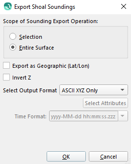
Export Shoal Soundings option from Dynamic Grid context menu in the Project Layers dock.
What it Does
This option lets you export the shoal soundings from the files used to create the selected dynamic grid.
General Description
This dialog will output a text file that contains a set of XYZ points representing the shoalest sounding in each cell of the selected area. If you have selected a rectangular area in the main view you can limit the export to that region by setting the Scope of Record Export to Selection instead of the Entire Grid. If the 'Export as Geographic (Lat/Lon)' toggle is set the soundings will be converted to geographic coordinates before they are output. The output format can be specified with the Select Output Format drop-down list and can either be ASCII XYZ Only, ASCII XYZ + Attributes, NAVO/CarisAscii, or ASCII + Date Time . When choosing to export Horizontal or Vertical Errors as additional Attributes, these will be represented as a 95% Confidence Interval value. When choosing ASCII + Date Time there will be an option to specify the Date/Time format from the drop down menu or simply editing the drop down menu.
Return to: Qimera Dynamic Grid Dialogs
Return to: Wizards and Dialogs
Return to: Qimera Interface