
On this page:
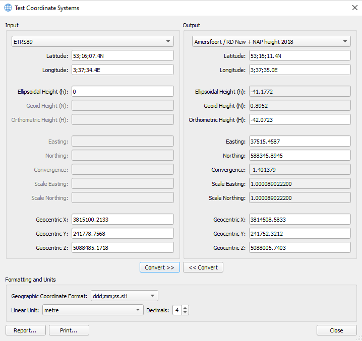
Test Coordinate Systems
This dialog is accessed via the Testing button from the Geodetic Configuration Overview.
It will take the configuration coordinate systems and put them in the Input and Output Coordinate System combo boxes.
You then choose which coordinate system you want as your Input and which one you want as your Output.
You will then be able to convert from one to the other.
If you choose a geographic coordinate system, you are able to enter coordinates as:
-
Latitude, Longitude and Ellipsoidal Height or
-
Geocentric X, Y, Z (although less likely and hardly used in practise)
If you choose a projected coordinate system, you can enter coordinates as:
-
Latitude, Longitude and Orthometric Height (in case of a configured geoid model) or
-
Easting, Northing and Orthometric Height
Then simply use the Convert buttons to convert one set of coordinates to the other.
Data Entry Fields
The following fields allow you to enter coordinates to test. Some of these fields are read-only and will be disabled by default.
Geographic Coordinates
If you have selected a geographic coordinate system type as your coordinate system to test, you must enter coordinates as geographic (or geocentric) type(s).
The following fields are editable.
|
Data Field Name |
Description |
|---|---|
|
Latitude |
Latitude of input or converted position. |
|
Longitude |
Longitude of input or converted position. |
|
Ellipsoidal Height (h) |
Ellipsoidal height of input or converted position. |
|
Geocentric XYZ |
Cartesian X, Y, Z (also known as Earth-Centred Earth-Fixed) coordinates of input or converted position. |
Projected Coordinates
If you have selected a projected coordinate system, you can enter either geographic, projected (or geocentric) coordinates.
|
Data Field Name |
Description |
|---|---|
|
Ellipsoidal Height (h): |
Computed height above ellipsoid as used by geodetic datum of the geographic coordinate system. Read only by default. |
|
Geoid Height (N): |
Computed height of geoid above ellipsoid as used by geodetic datum of the geographic coordinate system (in case of a configured geoid height model). Read only by default.
|
|
Orthometric Height (H): |
Vertical Coordinate System height of input or converted position. |
|
Easting: |
Position in X-direction of projected coordinate system of input or converted position. |
|
Northing: |
Position in Y-direction of projected coordinate system of input or converted position. |
|
Convergence: |
Grid convergence of input or converted position. Read only by default. |
|
Scale Easting: |
Easting scale of input or converted position. Read only by default. This quantity has twice as many decimals as the "Convergence" field. |
|
Scale Northing: |
Northing scale of input or converted position. Read only by default. This quantity has twice as many decimals as the "Convergence" field. |
|
Geocentric XYZ: |
Cartesian X, Y, Z (also known as Earth-Centred Earth-Fixed) coordinates of input or converted position. |
Formatting and Units
Geographic Coordinate Format
Available formats for geographic units are shown below (d=degrees, m=minutes, s=seconds, H=hemisphere).
The formats can include either a character describing the hemisphere (N = North; S = South; E = East; W = West) or a sign (+/-).
When entering or displaying degrees, minutes, seconds separately, the separating character can be either a space or a semi-colon.
|
Format |
Example |
|---|---|
|
ddd mm ss.ss H |
3 37 39.30 E |
|
ddd mm.mmmm H |
3 37.6550 E |
|
ddd.mmmmmm H |
3.627584 E |
|
+dd mm ss.ss |
+3 37 39.30 |
|
+ddd mm.mmmm |
+3 37.6550 |
|
+dd.dddddd |
+3.627584 |
|
ddd;mm;ss.sH |
3;37;39.3E |
|
ddd;mm;ss.sssH |
3;37;39.301E |
|
ddd;mm;ss.sssssH |
3;37;39.30150E |
|
ddd;mm.mmmmmH |
3;37.65502E |
|
ddd;mm.mmmmmmmH |
3;37.6550249E |
|
ddd.dddddddH |
3.6275837E |
|
ddd.dddddddddH |
3.627583749E |
Linear Unit
The Linear Unit choices are all available length related units from the geodetic units catalog.
The default linear unit is metre.
The list of possible choices in alphabetical order of appearance is as follows (metre in bold as default):
-
British chain (Benoit 1895 A)
-
British chain (Benoit 1895 B)
-
British chain (Sears 1922 truncated)
-
British chain (Sears 1922)
-
British foot (1865)
-
British foot (1936)
-
British foot (Benoit 1895 A)
-
British foot (Benoit 1895 B)
-
British foot (Sears 1922 truncated)
-
British foot (Sears 1922)
-
British link (Benoit 1895 A)
-
British link (Benoit 1895 B)
-
British link (Sears 1922 truncated)
-
British link (Sears 1922)
-
British yard (Benoit 1895 A)
-
British yard (Benoit 1895 B)
-
British yard (Sears 1922 truncated)
-
British yard (Sears 1922)
-
Clarke's chain
-
Clarke's foot
-
Clarke's link
-
Clarke's yard
-
German legal metre
-
Gold Coast foot
-
Indian foot
-
Indian foot (1937)
-
Indian foot (1962)
-
Indian foot (1975)
-
Indian yard
-
Indian yard (1937)
-
Indian yard (1962)
-
Indian yard (1975)
-
Statute mile
-
US survey chain
-
US survey foot
-
US survey link
-
US survey mile
-
centimetre
-
chain
-
fathom
-
foot
-
kilometre
-
link
-
metre
-
millimetre
-
nautical mile
-
yard
Report...
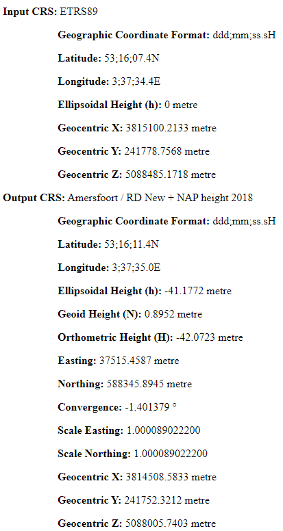
The Report... button will create an output file containing the source and target coordinate systems and the numerical values of the geodetic quantities.
Three output formats are supported being:
-
HTML (HyperText Markup Language)
-
PNG (Portable Network Graphic)
-
JPEG (Joint Photographic Experts Group)
The PNG and JPEG formats each create a screenshot of the Test Coordinate Systems dialog.
An example of an HTML formatted file is shown below:
Print...
The Print... button pops up the Print dialog, which allows you to send the test results to either a physical printer or a PDF (Portable Document Format) write application.