
How to Start
-
Scene Objects Dock → Right-Click on Object → Operations → Slope
-
Scene Objects Dock → Operations → Slope
What it Does
The Calculate Slope dialog allows the user to compute a surface that represents the maximum slope at each grid center of the currently selected SD.
General Description
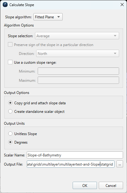
Slope Algorithm
Determines which algorithm to use when calculating the slope of a particular cell. The options are Fitted Plane, Balanced, and Simple.
Algorithm Options
Depending on the currently selected algorithm, there will be additional options to further customize the behavior of the chosen algorithm.
Slope selection
When using the Simple algorithm, the calculation can take into account the average, minimum, or maximum slope of its neighboring grid cells. Additionally, the simple algorithm can be adjusted to only consider cells from a specific cardinal direction.
Preserve sign of slope in a particular direction
When using the Balanced algorithm, the sign of the slope result can be adjusted to be relative to a specific cardinal direction.
Custom slope range
Optionally specify the slope range bounds for the generated grid color map.
Output Options
Options to determine the resulting output object.
Copy grid and attach slope data
The scalar will be attached to a new copy of the input grid and added to the scene. This means that when the surface of the object is picked, it will return X, Y, Z, and slope.
Create standalone scalar object
The scalar will be generated as a new standalone scalar object and added to the scene.
Output Units
Determines the units of the output scalar Z values.
Scalar Name
When using the Copy grid and attach slope data option, a name for the scalar can be specified. This is especially useful if there are multiple slope scalars attached to the same grid.
Output File
Specify the name for the output file. This will either be the new grid copy file name, or the standalone scalar file name.
Additional Notes
The generated surface will have the same dimensions as the original surface file and represents the maximum slope from each cell to any of its neighboring cells.
For the generated surface, each cell represents the maximum slope to any of its neighbors written in decimal degrees.
If the resulting grid will be an attached Scalar to a copy of the input grid, the grid can be re-shaded using the new attached scalar if Re-Shade with attached scalar is toggled on.