
How to Start
-
Scene Objects Dock → Right-Click on Object → Operations →IHO Uncertainty
-
Scene Objects Dock → Operations → IHO Uncertainty
What it Does
The Calculate IHO Uncertainty dialog calculates the uncertainty associated with the dataset. This uncertainty value will determine whether the data has met IHO order standards.
General Description
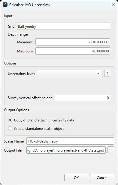
Input
Grid
The grid for which the IHO Uncertainty is required.
Depth Range
The depth range of the selected dataset.
Options
Uncertainty Level
You will need to set the uncertainty level to the correct level for your data. There are 4 levels of depth accuracy specified by the IHO per Special Publication Number 44: Special Order, Order 1, Order 2 and Order 3. The criteria for each in brief:
|
IHO Standards for Hydrographic Surveys |
|||
|
Special Order |
Order 1 |
Order 2 |
Order 3 |
|
Harbours, berthing areas, and associated critical channels with minimum underkeel clearances. |
Harbours, harbour approach channels, recommended tracks and some coastal areas with depths up to 100 m. |
Areas not described in Special Order and Order 1, or areas up to 200 m water depth. |
Offshore areas not described in Special Order, and Orders 1 and 2. |
Survey Vertical Height Offset
This feature is intended for is designed for lakes that are above sea level. If your data is bathymetric and below 0, then you will not need to use this.
Output Options
Copy Grid and Attach Uncertainty Data
This option is applicable when the user wishes to transfer their object to ArcGIS. It will copy the grid and attach the uncertainty to it.
Create Standalone Scalar Object
This option will create a scalar, which is an x,y attribute grid with the uncertainty as an attached scalar value.
Scalar Name
When using the Copy grid and attach uncertainty data option, a name for the scalar can be specified. This is especially useful if there are multiple uncertainty scalars attached to the same grid.
Output File
The filename of the grid with the according uncertainty value including its format extension, .statgrid.