
Storage - Grid

To be able to store data in a grid file, a grid file needs to be created first.
This can be done in the Session Setup by clicking on the "New" button.
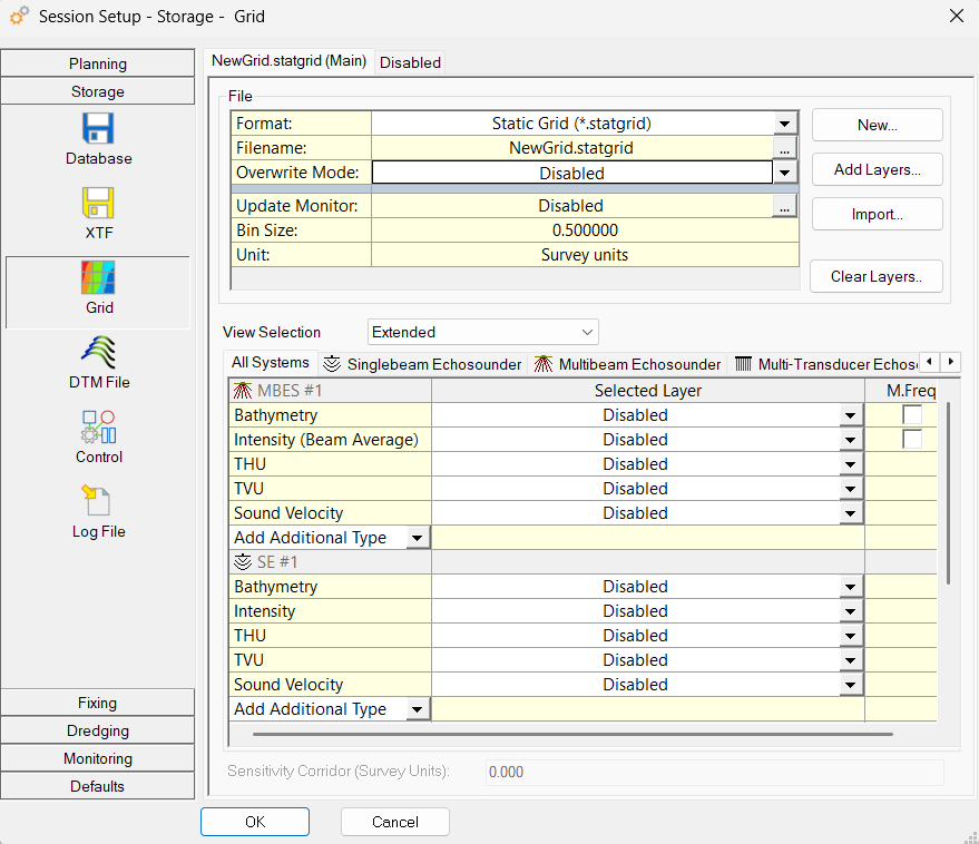
image-20260828-123345.png


File


Format

Select a "Static Grid (*.statgrid)" from the pull down menu when data needs to be stored in a sounding grid file.

Filename

Select the designated grid file by pressing the browse button. A standard MSWindows selection window will appear.

Overwrite Mode

In case the date attribute is available in the sounding grid an Overwrite Mode will be available.
By default data in the sounding grid will be automatically merged with newer data.
The attributes are set during creation of the sounding grid file or during creation of a new layer in the sounding grid.
A sounding grid or a new layer are created using the Sounding Grid Utility or directly in the Session Setup by using the "New" button.

  • Age - In case the last update in a cell has a certain age the cell will be cleared and filled with newer data.

    • Used when using a Multibeam on a cutter dredger. When swinging in a cut the data can be averaged if the data is not older than the threshold age set.

    • This can be useful if you want to redo a survey line and only want to overwrite the sounding grid data of the previous attempt.

  • Time (older than) - In case the data in a cell is older than the time and date entered by the user, the cell will be cleared and filled with new data.

Age (minutes)

Only visible when Overwrite Mode is set to Age.

Date

Only visible when Overwrite Mode is set to Time (older than).

Time

Only visible when Overwrite Mode is set to Time (older than).

New…

Pressing new will open the “Create a new static grid” dialog. For more information please refer to CreateStaticGrid

Clear Layer…

Erase all data from a selected layer in the currently selected sounding grid file.
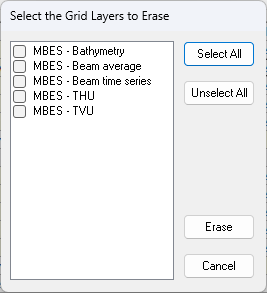
image-20260831-125050.png

First select a layer, then press <Erase>.

Import…

Import data (points file or another grid file) into the currently selected sounding grid file.
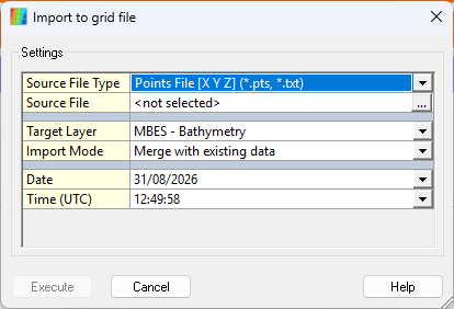
The options are similar to the Import option in the Sounding Grid Utility.

image-20260831-125027.png


Press <Execute> to start the import.

Systems


System

For each system a storage layer can be selected.
This can be a different layer or the same layer.
In the Sounding Grid only data which passed the online filters as set in the Echosounder Settings will be stored.
The motion (roll, pitch, heave), height settings etc. are already applied to the data if this information is available online.

When a magnetometer is present, a magnetometer grid can be created and activated.
A corridor can be set which will look like a swath from a Multibeam echosounder, containing the one value of the magnetometer over the whole corridor width.
This 'swath' will show in the Navigation Display to indicate which area has been covered by the magnetometer survey.
The maximum width of the corridor is 100 times the minimum cell size of the sounding grid.

Layer

These layers can be defined in the Sounding Grid Utility or in the <New> option above, using the <Add layer> button.
For multibeam systems it is also possible to write, besides bathymetric data, backscatter data to a sounding grid file.
So for each multibeam system you will find two entries in the list: one for bathymetry and one for backscatter.

It is advised to write this information to two different layers in the sounding grid file to make a clear distinction between the two types of data.

View Selection

Select a view mode from the dropdown menu (Extended, Normal, and Basic). To limit the amount of information that is shown, the following view modes can be selected:

  • Extended

    • Show all available layers and allow the addition of additional types.

    • For example, in the case of a multibeam system, the following layer types are shown:

      • Bathymetry, Intensity (Beam average) and Intensity (Beam Time Series), THU, TVU, Sound Velocity, <Add Additional Type>

  • Normal

    • Show a limited selection of commonly used layers of each system type.

    • For example, in the case of a multibeam system, the following layer types are shown:

      • Bathymetry, Intensity (Beam average) and Intensity (Beam Time Series)

  • Basic

    • Only show the most common layer type.

    • For example, in the case of a multibeam system, the following layer types are shown:

      • Bathymetry


It is also possible to limit the number of systems shown by selecting one of the tabs below “View Selection”. From here you can select which system(s) are shown and their corresponding layers.

  • If you select “All Systems”, all systems will be shown and their corresponding layers depending on the view mode selected.

  • If you select “Singlebeam Echosounder”, your Singlebeam echosounder systems will be shown and their corresponding layers depending on the view mode selected.

Return to: Storage