
The QPS team is continuously improving Qinsy to implement new functionality and documentation.
Unfortunately, there are a number of known issues in our software release.
These software issues will be solved in future maintenance releases.
For this release the following issues are known
Table of Contents
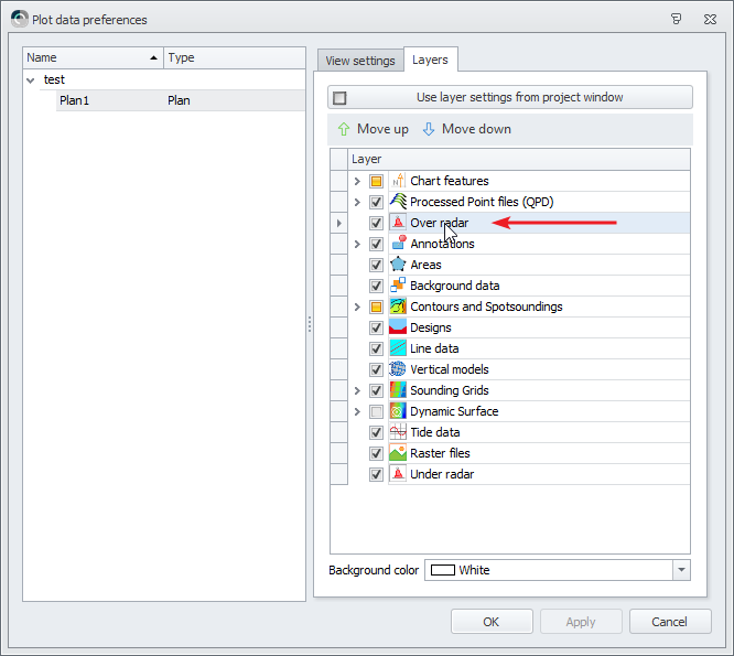
Survey Manager - Plotting - Plan View - Crash due to ENC object in Over Radar layer
Problem
The Survey Manager crashes when you plot an ENC with objects like buoys, lights, etc. in it.
Workaround
Disable the Over Radar layer in your plot:
Planned fix
This is planned to be fixed in Qinsy 9.5.4.
If you cannot wait until then, please contact support so a Beta release can be send.
Displays - Navigation - CAD
Converting a design file into a background file will not show lines when the start and end point of a line are outside the view. (Viewing Panel)
Recommendation:
Do not convert design files into background files. If lines from a design are needed in the Navigation Display, then create a dedicated background file.
Displays - Navigation - CAD Survey Manager
The QPS team encountered a memory problem with CAD files which contain many complex blocks.
Recommendation:
Do not use CAD files which contain many complex blocks. This bug will be solved in a future maintenance release.
Displays - Navigation - ENC Survey Manager
Both the Survey Manager and Navigation Display are not Per monitor DPI aware.
With two monitors, each with different display scales, the scale on the secondary monitor will not be correct.
This also affects the way the ENCs are drawn.
Recommendation:
Please vote on: FQI-605 - Survey Manager - Plan View - Make per monitor DPI aware
Survey Manager - Plan View - ENC
ENCs produced by Rijkswaterstaat for the Dutch province of Zeeland and ENCs produced by the Netherlands Hydrographic office cannot be displayed simultaneously due to the different usage levels and compilation scales of both producers.
For more information and updates: https://vaarweginformatie.nl/frp/main/#/page/infra_enc
Survey Manager - Sounding Grid - Import Geoid Model
Since Qinsy 9.5.0 it is possible again to import most Geoid models into a sounding grid.
The only Geoid models that cannot be imported yet, are the ones that cross the dateline (+180° East/West).
Please let us know if you do need to import such a model.