
Bugs Solved
Below is a list of the important issues that have been resolved and functionality that has been implemented in this release. This list is not exhaustive.
INSTALLATION
-
Setup - Installation - Link to downloads section needs to be updated
CONSOLE
-
Console - Auto moving files - QGFDes(ign) is not moved to correct folder
-
Console - IO Driver Editor - Positioning System - Strip letters from Height Field
-
Console - License manager - License Manager is not starting from warning
-
Console - Project Upgrader - Can be skipped before the actual finish
-
Console - Project - File management - GeoTiff tfw files should move to Graphics folder
-
Console - SNTP server - Application will not start
DRIVERS
-
Drivers - Camera - BASLER - Crashes when first image captured (Fixed crash located in file name generation of the QGF file.)
-
Drivers - INS - iXBlue - STD BIN - Connection not restored.
-
Drivers - INS - Sonardyne LNAV - Binary field 'Altitude' (height above seabed): decoded value was off by a factor 10. This has been corrected.
-
Drivers - INS - Sonardyne LNAV & ROVINS Haliburton or Output drivers - Deskew always outputs in survey datum
-
Drivers - MBES - Kongsberg - EM2040 C - EM Controller shows 'Special Amp Detect' twice
-
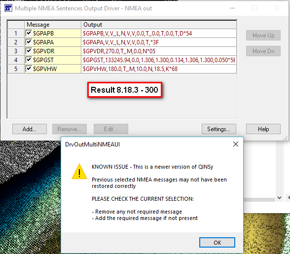
Drivers - Output - NMEA - Output messages changed with upgrade to 8.18.2
The disabled messages were caused by a new message type that was added: GST.
If you set it up in 8.18.2, it will not be a problem anymore in 8.18.3.
Note that the pop-up message will pop up once so as to make sure you read it and check the selected output messages.
Verified this in 8.18.3 - 300. -
Drivers - Output - NMEA - Warning may pop up after upgrading from QINSy v8.18.1
ONLINE
-
Online - Callibration - Position fix - Decimals in Calibration report (Now using project settings)
-
Online - Computation - Tide - Auto tide selection based on KP line not working anymore due to *.PRO
When starting the Controller, we check if the mainline is a *.pro file and try to look for the *.QGF line file. If found, that is used instead, or else we will inform the user that they need to add the line manually. -
Online - Computation - RTK Tide - Causes problems with SVP comparison.
-
Online - Computation - RTK Tide - Cannot be selected until OK is pressed first.
-
Online - Echosounder settings - SVP - Connect to Logger - All have the same date and time
-
Online - Echosounder Settings - SVP - Connect to Logger - Valeport Swift - Use Pressure during import Bin format
Import file and select the binary format:
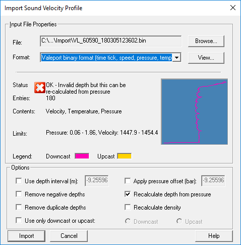
Make sure that 'Recalculate depth from pressure' is ticked. Click the 'Import' button.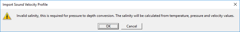
This message box shows up, if the profile contains temperature, pressure and velocity.
If the profile does not contain valid temperature, pressure and velocity the message box says it will use the default values for salinity, as it did before.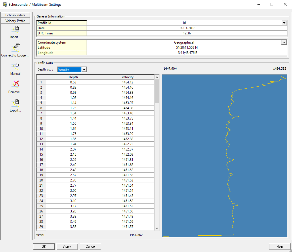
A profile is imported.
Note: the calculated depth is not exactly the same as the matching vpd file has. The initial calculated depth is exactly the same, but we apply a GPA (Geo Potential height Anomaly) correction to the depth. Valeport does not do this in their DataLog software
This GPA correction causes a 6 cm offset at a depth of 18 meters in this particular profile.
A formula to calculate salinity has been added to the Import Sound Velocity Profile dialog in the Controller Echosounder Settings form. If a profile contains valid temperature, pressure and speed of sound the algorithm calculates salinity which is used to recalculate depth.
This new formula is only used when the option 'Recalculate depth from pressure' is ticked. -
Online - Echosounder Settings - SVP - Negative temperatures warning
-
Online - Echosounder Settings - SVP - Recalculate depth should take Salinity into account
-
Online - Echosounder Settings - SVP - Valeport - Format error when importing empty binary SVP file
-
Online - Session Setup - Fixing - FIX number resets after recording is paused

DISPLAYS
-
Displays - Echosounder - Depth and WCD / echo trace does not fit for EA440
-
Displays - Echosounder
View Properties: You will now have the option to show the single-beam depth value as:
- the raw depth (as reported by the unit and decoded by the driver)
- the depth below transducer (corrected for draft settings from Db Setup)
- the water depth (on chart datum)
Further, if watercolumn data is available it will also be corrected for the selected option.
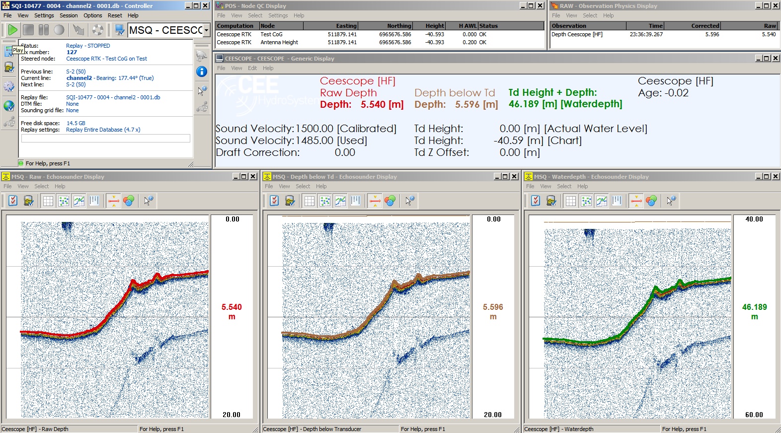
In the above example you can see three Echosounder Displays: showing the same data but with different values and vertical scales. The information in the status bar indicates which option has been selected. -
Displays - Navigation - CAD - Background - Updated faster in older versions
-
Displays - Navigation - CAD - Line Planning - Points - Circles stay visible when not active
-
Displays - Navigation - Layer overview - Reset to default layer order crashes the display
-
Displays - Navigation - Objects - Nodes - Overscale symbol not displayed unless vessel shape is configured in setup
-
Displays - Navigation - Toolbars - Lost buttons after minimizing with custom made toolbars
-
Displays - Navigation - Quick profile shows fake data
-
Displays - Navigation - Quick profile interaction bug - Profile and Nav display do interact when the other (than only bathy) layers (Bathy + Intensity layers) are enabled
-
Displays - Profile - CAD - Line Planning - Displays line file at the wrong depth
-
Displays - Profile - Object Shape - After shift in DbSetup object is not drawn anymore
-
Displays - Profile - Terrain - Adding a design (QGFDes) results in crashing of display
-
Displays - Raw Multibeam - WASSP S3 - Bathymetry decoded but not shown (Positioning system was not interfaced, resulting in no computation trigger)
OFFLINE / REPLAY
-
Offline - Export - Generic - QPD - Pipe Tracker - Can not export detected pipe ping based
-
Improved the export of QPD on Ping base/MP interval:
The given MP interval should be a positive number, regardless of whether the survey was done with increasing or decreasing MP values. This is now detected automatically by the export process.
-
-
Offline - Export - SEG-Y - Innomar - Incredibly slow
-
Offline - Import - ASCII - KOAC WMD format not available anymore
-
Replay - Computation - 1st and 2nd replay compute different results
PM.NET
-
PM.NET - Crashes when resetting to factory defaults
-
PM.NET - CAD - Annotation - Crash when selecting edit annotation
-
PM.NET - CAD - Area - Unable to select a boundary
-
PM.NET - CAD - Line Planning - Changing color of circle makes it disappear
-
PM.NET - CAD - Line Planning - Crash when selecting lines
-
PM.NET - CAD - Line Planning - Edit Objects - When a section is added to a polyline, it is not displayed instantly
-
PM.NET - CAD - Line Planning - Export - Wrong default folder location by wizard (now Project export folder)
-
PM.NET - CAD - Line Planning - Extract from file - not possible to Design
-
PM.NET - CAD - Line Planning - Import - PRO-files as Line Data
-
PM.NET - CAD - VOM - Import points directly or into an empty file doesn't update in plan view
-
PM.NET - File Management - Explorer - Not all items translated to German
-
PM.NET - File Management - CAD - Lines stay visible even though they are switched off
-
PM.NET - Plan View - Raster - GeoTiff - Image sometimes not not visible
-
PM.NET - Plan View - Settings - Text not consistent in upper- and lower case
-
PM.NET - Plan View - Settings - Geographic grid - Always formatted as dd;mm;ss.sss
-
PM.NET - Profile - Changing plan view layer settings is creating multiple profiles
-
PM.NET - Profile - Export - Gaps in profiles due to hard to find link settings
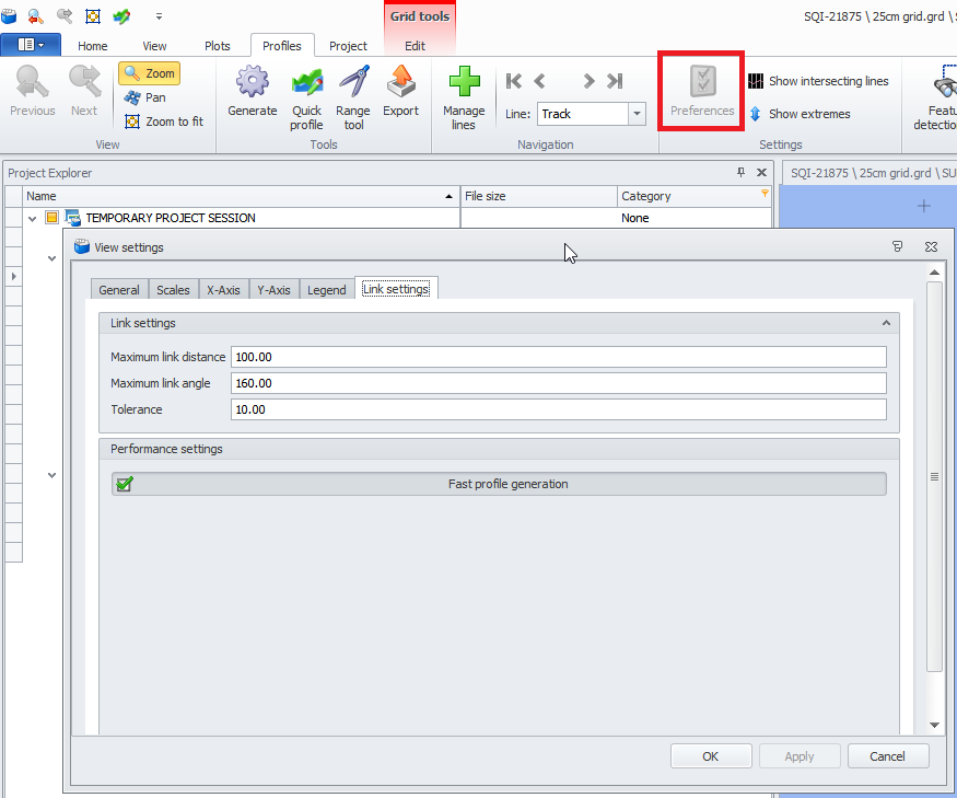
We added the Link settings to the Profile View Settings
-
PM.NET - Plotting - Left Fixed Scale not remembered
-
PM.NET - Plotting - Profiles - Error message when start and end distance (KP) along the line (route) are changed
-
PM.NET - QPD - Export - ASCII - Selected XML is not used to retrieve settings
-
PM.NET - Sounding Grid - Contours and Soundings - Cancelling results in crash
-
PM.NET - Sounding Grid - Difference - Using Design as reference layer results in crash
-
PM.NET - Sounding Grid - Export - Crash after changing scale factor in user defined export format
-
PM.NET - Sounding Grid - Export - Geotiff - Exporting 95% Confidence Level is not working
-
PM.NET - Sounding Grid - Grid Edge - Functionality is not available for new created grids
-
PM.NET - Sounding Grid - Import - Geoid - Cancel button doesn't work
-
PM.NET - Sounding Grid - Import - Hangs on import of large ASCII files
-
PM.NET - Sounding Grid - Import - Scale factor set to 0 by default (now set to 1)
-
PM.NET - Sounding Grid - Interpolation - Write method should not be available
-
PM.NET - Sounding Grid - Layer Properties - Colors should by default show custom colors
-
PM.NET - Sounding Grid - Operators - Adding Design model still referring to .qgf (now *.qgfdes)
-
PM.NET - Sounding Grid - Volumes - Crashes when reference is Design and fields are empty (now a warning is given)
-
PM.NET - Startup - Will not open project session due to missing Common Project (now a warning is given)
-
PM.NET - Tide - Tide definition file path not shown
-
PM.NET - Wrong path in warning when missing geoid