Skip table of contents

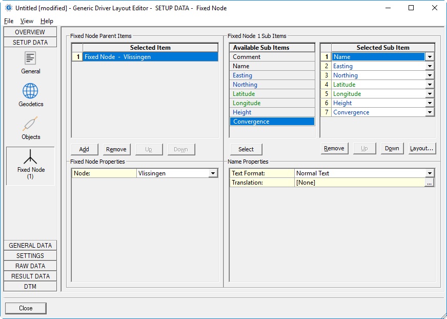
Fixed Node


Parent Item
Node:List with all available fixed node locations, existing in the current selected Qinsy database.
(see General Layout Information about loading a Qinsy database).
Sub ItemDescriptionValue Type

Property

CommentUser-defined texttext
Text Format
  • Normal Text
    Your own free plain text
  • Binary
    Enter one or more ASCII character codes, comma or space separated, in the range between 1 and 127.
    For example '2' for a binary STX character, '3' for a binary ETX character, or '13, 10' for CR+LF.
    See table ASCII Codes for an overview of all possible characters.

  • New Line
    Same as Binary but already formatted as '13, 10' (meaning CR+LF) and without a possible Field Delimiter.
    A Field Delimiter may be present when your layout purpose is for Export or ASCII Logging.
NameName of the fixed node, as entered in Db Setuptext
EastingEasting of the fixed node location, from the position as defined in Db Setup.
Always on Survey Datum.
If you only define geographical co-ordinates in Db Setup, the projection grid co-ordinates will be calculated automatically.
double

Northing

Northing of the fixed node location, from the position as defined in Db Setup.
Always on Survey Datum.
If you only define geographical co-ordinates in Db Setup, the projection grid co-ordinates will be calculated automatically.

double

Latitude

Latitude of the fixed node location, from the position as defined in Db Setup.
Default on Survey Datum, but may also be on WGS84.
If you only define projection grid co-ordinates in Db Setup, the geographical co-ordinates will be calculated automatically

geo


Datum:

  • Survey Datum (default)
  • WGS84
    Assumption is that the WGS84 datum is part of the Geodetic Setting in DB Setup.

Longitude

Longitude of the fixed node location, from the position as defined in Db Setup.
Default on Survey Datum, but may also be on WGS84.
If you only define projection grid co-ordinates in Db Setup, the geographical co-ordinates will be calculated automatically.

geo

Datum:

  • Survey Datum (default)
  • WGS84
    Assumption is that the WGS84 datum is part of the Geodetic Setting in DB Setup.

Height

Height of the fixed node location, from the node height as defined in Db Setup.
It will be the sum of the defined Station Height, the Instrument Height and a possible Height Level and Height Offset.
Default on Vertical Datum, but may also be on Survey Datum or WGS84.

double

Datum:

  • Survey Datum
    Height value will be on the selected survey datum ellipsoid, e.g ED50.
    Survey datum is set in the template database setup, Geodetic Parameters, 'Output Datum Parameters' Wizard page.
  • WGS84
    Height value on the WGS'84 datum.
    Notice that WGS84 must be one of the two selected datums in the template database setup, Geodetic Parameters, 1st Wizard page.
  • Vertical Datum (default)
    Height value on the selected vertical datum e.g NAP, De Min Geoide.
    Vertical datum is set in the template database setup, Geodetic Parameters, 'Output Datum Parameters' Wizard page.

Convergence

The meridian grid convergence for the position of the fixed node location, as defined in Db Setup. Depends also on the selected geodetic projection.

double


JavaScript errors detected

Please note, these errors can depend on your browser setup.

If this problem persists, please contact our support.