Zoned Tides (ZDF) format
This document describes details of the ZDF Zoned Tides format.
On this page:
Format Description
General Notes
All fields are comma delimited, there is no specification on whitespace usage between fields though. All sections should be followed by a blank line.
Sections
[ZONE_DEF_VERSION_2] or [ZONE_DEF_VERSION_3]
This is the header section that specifies the ZDF version. It has no records.
[ZONE]
This section is repeated for each zone to define the polygon in which the associated gauge(s) and correctors are applicable.
The first line contains
- zone label
- vertex count
Following records contain the position of each vertex with
- latitude
- longitude
Example:
[ZONE]
WGM277,5
29.224709, -91.185916
29.220308, -91.160837
29.005056, -91.282961
28.968641, -91.399733
29.224709, -91.185916
[TIDE_STATION]
This is a list of all the tide stations referenced by zones or tide averages.
Unless otherwise specified (as in version 3) the tide files are assumed to be located in the same directory as the .zdf and take the form of "(station label).tid"
In version 2 each record includes
- station label
- latitude
- longitude
Example:
[TIDE_STATION]
8762075, 29.115000, -90.206700
8763535, 29.173333, -90.975000
...
In version 3 the record additionally includes
- maximum amplitude (meters)
- uncertainty value
- (optional) tide file path.
Example:
[TIDE_STATION]
8762075, 29.115000, -90.206700, 2.0, 0.15, C:\Tides\8762075.tid
8763535, 29.173333, -90.975000, 1.5, 0.10, C:\Tides\8763535.tid
...
[TIDE_ZONE]
This defines the relationship between the zones and the tide stations.
For version 2 each record contains
- zone label
- station label
- priority - this can be: PRIM, SEC, TER, or PRELIM; meaning: primary, secondary, tertiary, or preliminary, respectively.
- time offset, or corrector (minutes)
- amplitude scalar, also referred to as range corrector - this is a multiplier for the tide height to scale the amplitude
- (optional) tide file path
Example:
[TIDE_ZONE]
CGM716, 8763535, PRIM, -24, 0.836
WGM264, 8763535, PRIM, -36, 0.963
...
For version 3 the tide file path is not an option, but the follow additional fields are included
- tidal shift (meters) - this is a vertical shift of the tide height to be added after scaling
- uncertainty - this is an uncertainty for the tidal zone
Example:
[TIDE_ZONE]
CGM716, 8763535, PRIM, -24, 0.836, 0.0, 0.2
WGM264, 8763535, PRIM, -36, 0.963, 0.0, 0.2
...
[TIDE_AVERAGE]
These are lists of tide stations to average for use in the designated zone. Averaging is done after corrections specified in [TIDE_ZONE] are applied.
In many cases no averaging is needed but stations are listed redundantly in this section.
Records include
- zone label
- comma separated list of 2 or more station labels to average
Example:
[TIDE_AVERAGE]
CGM716,8763535,8763535
WGM264,8763535,8763535
...
[OPTIONS]
There are only two standard options
- Outage (minutes) - if missing records, the time after which to switch to the next priority station
- Interval (seconds) - final interval of tide heights loaded into the line
Example:
[OPTIONS]
Outage, 30
Interval, 360
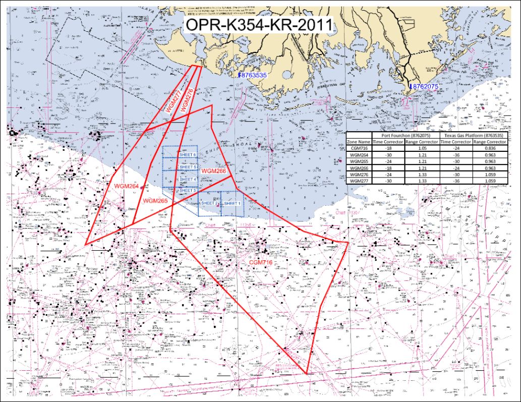
Example: OPR-K354-KR-2011
This example comes from the Body and Appendices of NOAA Descriptive Report H12331.

Location of survey area, tide zones, tide stations 8762075 and 8763535 and the
time/range correctors for those tide stations.
ZDF file (version 2)
[ZONE_DEF_VERSION_2]

[ZONE]
CGM716,14
28.516196,-90.501009
28.471404,-90.519688
28.265943,-90.630658
28.001139,-90.699347
28.371610,-91.091603
28.575123,-91.295343
28.674869,-91.281683
28.786847,-91.016701
28.734720,-90.992780
28.658449,-90.872902
28.562754,-90.699401
28.547356,-90.644364
28.519663,-90.553010
28.516196,-90.501009

[ZONE]
WGM264,7
28.968641,-91.399733
29.005056,-91.282961
28.841561,-91.375255
28.601696,-91.461815
28.522274,-91.674134
28.788473,-91.550173
28.968641,-91.399733

[ZONE]
WGM265,7
29.005056,-91.282961
29.032404,-91.203049
28.876853,-91.254013
28.674869,-91.281683
28.601696,-91.461815
28.841561,-91.375255
29.005056,-91.282961

[ZONE]
WGM266,7
29.032404,-91.203049
29.066476,-91.098476
28.977116,-91.103401
28.786847,-91.016701
28.674869,-91.281683
28.876853,-91.254013
29.032404,-91.203049

[ZONE]
WGM276,5
29.220308,-91.160837
29.217374,-91.142446
29.032404,-91.203049
29.005056,-91.282961
29.220308,-91.160837

[ZONE]
WGM277,5
29.224709,-91.185916
29.220308,-91.160837
29.005056,-91.282961
28.968641,-91.399733
29.224709,-91.185916

[TIDE_ZONE]
CGM716,8763535,PRIM,-24,0.836
WGM264,8763535,PRIM,-36,0.963
WGM265,8763535,PRIM,-30,0.963
WGM266,8763535,PRIM,-24,0.963
WGM276,8763535,PRIM,-30,1.059
WGM277,8763535,PRIM,-36,1.059

[TIDE_STATION]
8762075,29.115000,-90.206700
8763535,29.173333,-90.975000

[TIDE_AVERAGE]
CGM716,8763535,8763535
WGM264,8763535,8763535
WGM265,8763535,8763535
WGM266,8763535,8763535
WGM276,8763535,8763535
WGM277,8763535,8763535

[OPTIONS]
Outage, 30
Interval, 360
