Qimera Tide Strategy Dialog

How to Start
- Right-click on Tides or Strategies group in the Project Sources Window and select Create Tide Strategy from the context menu
- Right-click on an existing Strategy in the Project Sources Window and select Edit Tide Strategy from the context menu
- Double-click on an existing Strategy in the Project Sources Window
What it does
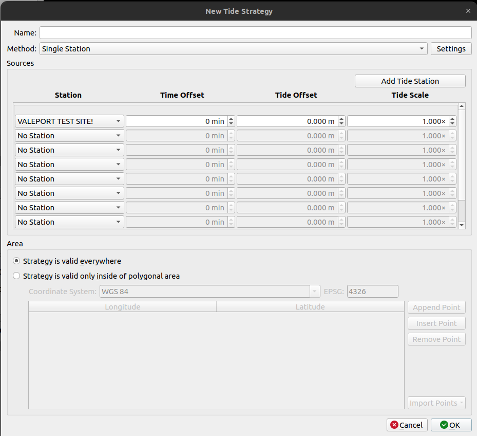
The dialog allows for creating or editing a Tide Strategy that can be used as a tide source for vertical referencing.
General Description
Tide strategies can be used to apply advanced computations, constraints, and offsets to compute a tide estimate for a region or vessel location based on measured tide values. The Tide Strategy dialog is used to configure all of the settings needed for the tide estimation.
The dialog has several section, these are explained below.
Name
The name is only used for display purposes and only needs to be unique within the project.
Method
The selection of a Method changes the computation used and is based on the number of stations being used and the desired computation.
Each of the available methods are described below.
Single Station
The Single Station method allows for applying source offsets or area constraints to a single station. If more than one station is included in Sources the additional stations will be switched to in order based on data availability.
Average
Averages tide measurements from all stations available from Sources.
Two Station Linear Interpolation
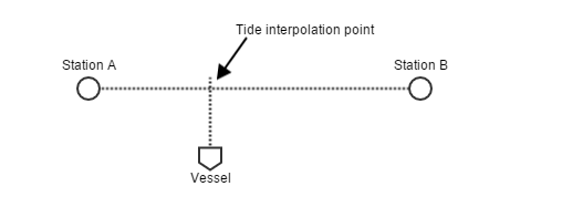
The Two Station Linear Interpolation method uses the projected position of the vessel onto the straight line connecting two tides stations. The tide value is interpolated on the straight line between the two stations.

If the location of the vessel passes either station instead of extrapolating the nearest station will be used.
Multiple Station Distance Interpolation
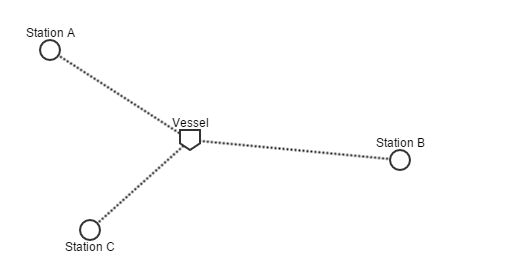
The Multiple Station Distance Interpolation method performs a weighted average of all tide stations included in the strategy. The weighting is determined by the vessel distance to each station, the closer a station is the more influence it has on the resulting tide value.

Linear Co-Tidal Interpolation
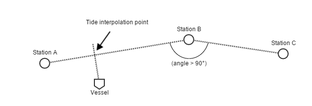
The Linear Co-Tidal Interpolation method interpolates both the tidal phase and amplitude between 2 stations. It is similar to the Two Station Linear Interpolation method as it uses the projected position of the vessel onto the straight line connecting the two nearest tides stations. More than 2 stations can be stringed together but the line connecting the stations cannot make an angle of less than 90 degrees.
The phase interpolation is computed by detecting the nearest high water in time at both of the nearest 2 stations. The time offset between the 2 high waters is weighted by distance on the line connecting the 2 stations and used to shift the tide signals to a common phase.

Tide measurements can't be determined past the terminal stations in the line of stations.
Tide Constituent and Residual Interpolation (TCARI)
The TCARI strategy is used to show information about about a TCARI model imported through Add Tide Definition File Dialog. The strategy does not directly provide any tide calculations.
Settings
Clicking the Settings button next to the method will launch a dialog that presents general settings for all methods.
Co-Tidal calculation order
This relates to the order that the offset and scale factor configured in the Sources section are applied. The tide computation will use one of the following equations based on this setting:
| Option | Equation |
|---|---|
| Scale first (default) |  |
| Offset first |  |
Where tPing is the time of the ping.
Max interpolation gap
If enabled, this is the maximum time between tide measurements to allow interpolation of the measurement. This can be used to prevent interpolation across large outages.
When interpolation is prevented by this setting the next lower priority tide source that is available will be used.
Sources
The Sources section is used for selecting appropriate stations for the method, and setting any offsets or scaling of tide values. The number of station dropdowns is determined by the selected method.
The offsets and scale factor are applied to the station tide measurements before inclusion in the method's calculation for each ping time. See the Settings section above for how these are used in the calculation.
Area
The area settings are used to restrict the use of a strategy to a specific geographic area. By default strategies are applied throughout the project.
If using a polygon to restrict the area where the method is valid, or in other words to be applied, the polygon can be entered manually or imported in either geographic or projected coordinates.
The Coordinate System must be set and will be used to convert the polygon from the input system to the project coordinate system.
Manual Point Entry
The buttons to the right of the table are used to insert or delete polygon points. Once inserted a points coordinates can be modified directly in the table.
Importing Points
There are three options for importing a polygon. The options for importing are available from the Import Points dropdown at the bottom right side of the table.
- Import from current selection in scene - if you have made a selection with one of the select tools on the 4D Scene Toolbar the selection coordinates will be imported to the polygon table (disabled if no selection made)
- Import from line object - if you have already imported an SD line object to the project this can be imported as the polygon (disabled if no line objects imported)
- Import from ASCII file - this will launch the Custom ASCII File Import dialog, which will allow for import of formats that list one coordinate per line
Return to: Qimera Interface
Return to: Wizards and Dialogs
