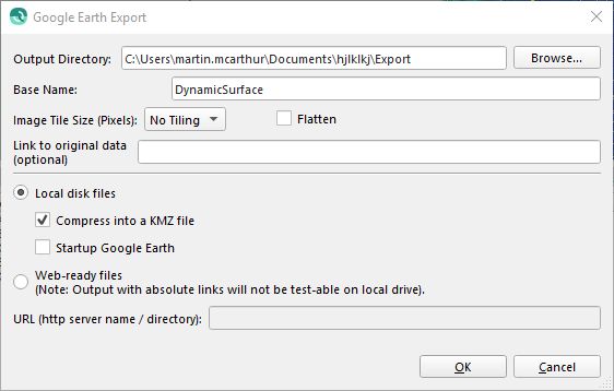
Qimera Export Grid To KML Dialog

How to Start
Export to KML... option from the Export→Dynamic Grid sub-menu of the Main Menu toolbar.
Export to KML... option from the Export→Static Grid sub-menu of the Main Menu toolbar.
What it Does
This dialog will export the selected Grid to a Google Earth comparable KML or KMZ file.
General Description
Exporting to KML can be configured with the following options.
Output Directory
The Output Directory indicates the path to the directory where the file will be saved. This path can be modified using the Browse button.
Base Name
The Base Name textfield contains the filename that will be used when saving the file.
Image Tile Size
Selecting an Image Tile Size from the ComboBox will limit KML files to the selected tile/pixel size. Additional files will be created to ensure the entire Grid is exported. If No Tiling is selected a single KML will be exported.
Flatten
When 'Flatten' is unchecked all KML exports are created with Altitude Mode 'clampToSeaFloor'. This mode ignores any altitude values and drapes the feature on the bottom of any major body of water. If the feature is located away from a body of water the feature will be clamped to the ground level instead.
Checking the 'Flatten' button export the KML with no Altitude Mode resulting in a flat image.
Link To Original Data
Including a link in this textfield will add the KML link tag in the exported file.
Local Disk Files
Creates the file on the local disk with the two following options;
Compress into a KMZ file
Compresses the KML files into a single KMZ file. This will not delete the original KML files.
Startup Google Earth
Selecting this option will attempt to launch the Google Earth Application if it is installed on the local pc with the exported file.
Web-ready files
Files can be uploaded to a server after creation.
URL
The url of the server.
Return to: Qimera Interface
Return to: Qimera Wizards and Dialogs
