Qimera 2.3.2 Release
4 February 2021
We are pleased to present Qimera 2.3.2
Highlights
In the 2.3.2 release there area few improvements made to the 2.3.0 features based on user feedback. We've also fixed several recently reported bugs.
Shift Tools - Common export user experience and auto-reporting
High-level access to export actions on the main interface of all the recently added shifting tools. There is also a new auto-export capability that saves critical reporting elements after the tool is successfully run.
Horizontal Shift Tools - New contour matching method
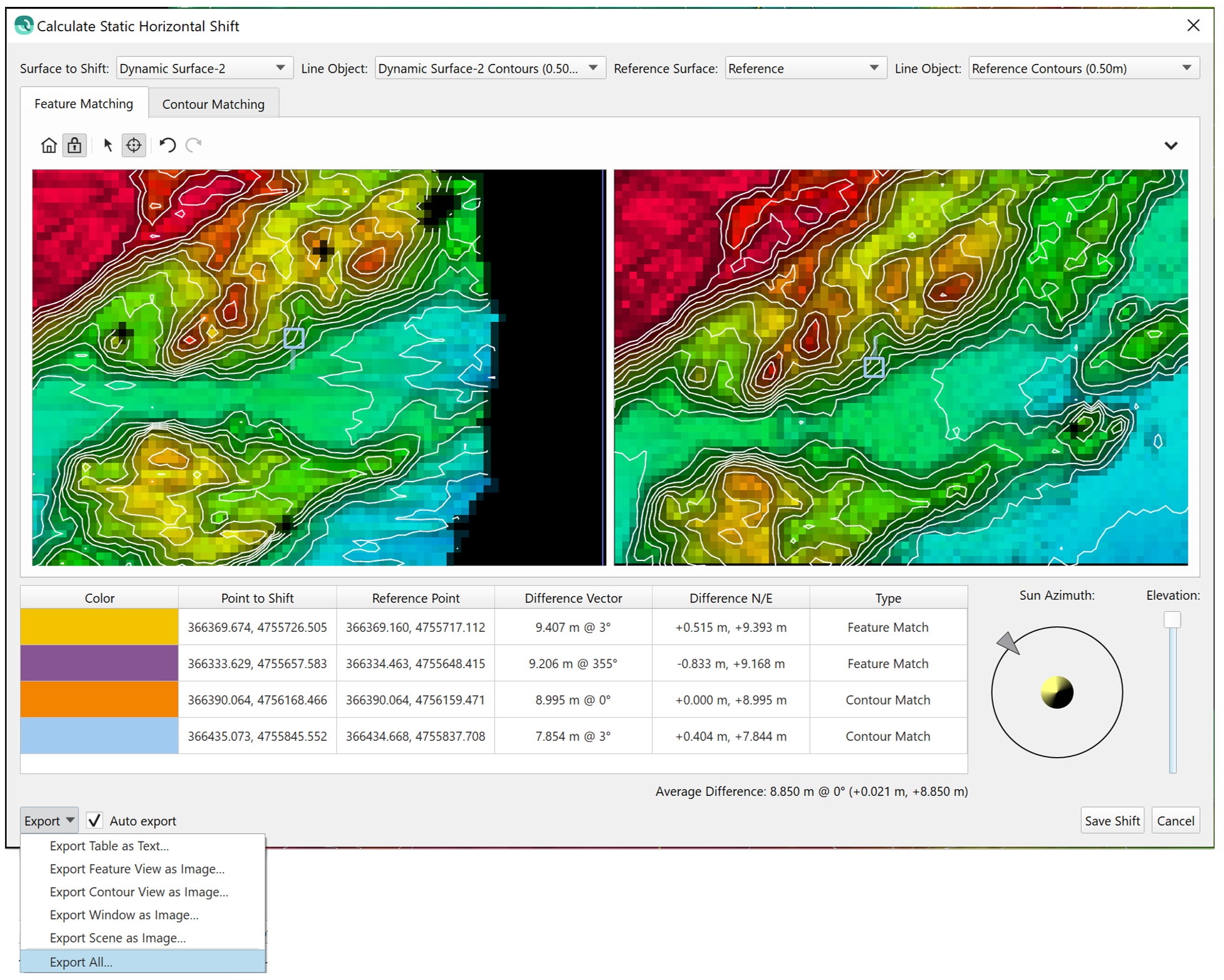
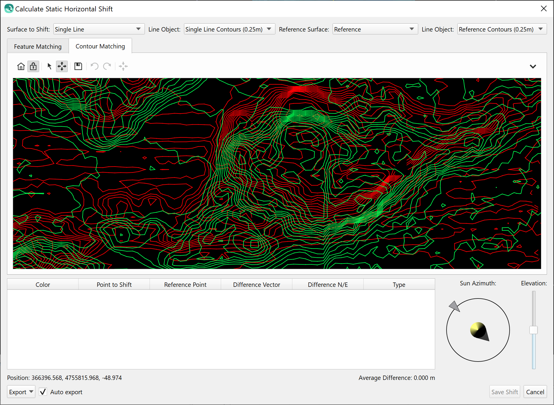
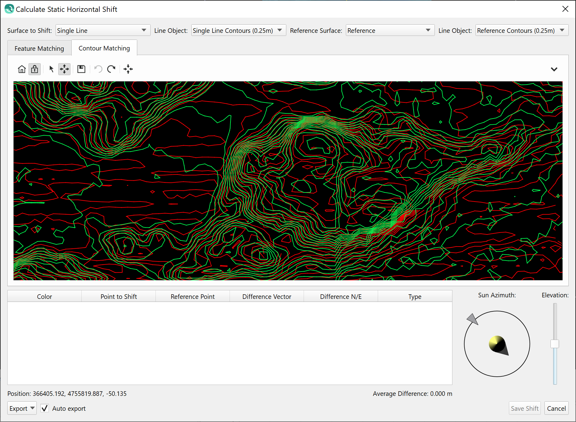
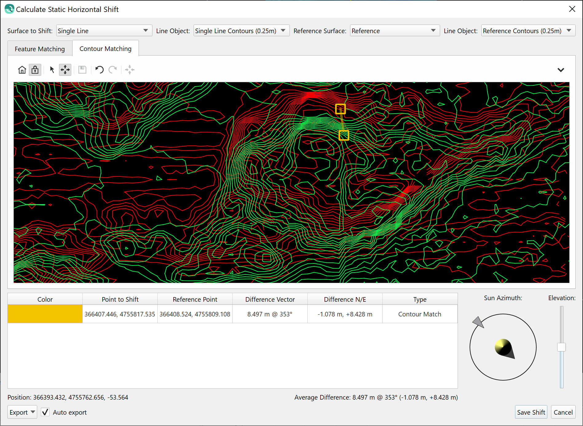
We've added new capability to do contour matching as a second method of assessing horizontal shifts, primarily for areas that don't have many linear or discrete seabed features. The image sequence below shows how it can be used in conjunction with the original terrain model matching approach.
Step 1 - Examine contours with overlay to highlight misalignment.
Step 2 - Use the align button to manually align the contours.
Step 3 - Hit the 'Save' button, a new fiducial pair is saved in the table. The contours are drawn in their original position with a fiducial marker. Go to another area to align the contours there and save other fiducial pairs to come up with a good average offset across the surface. Note that you can use this method as well as the terrain matching method to collect a blended set of fiducial points. The selection method is recorded in the table and is also included in the ASCII export.
KP on Routes - Ability to add marker labels
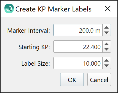
Label markers can be added to a Route via the right-click context menu from the selected Route in the Project Layers dock. You can set the marker interval and the KP labeling starting KP, along with the label size.
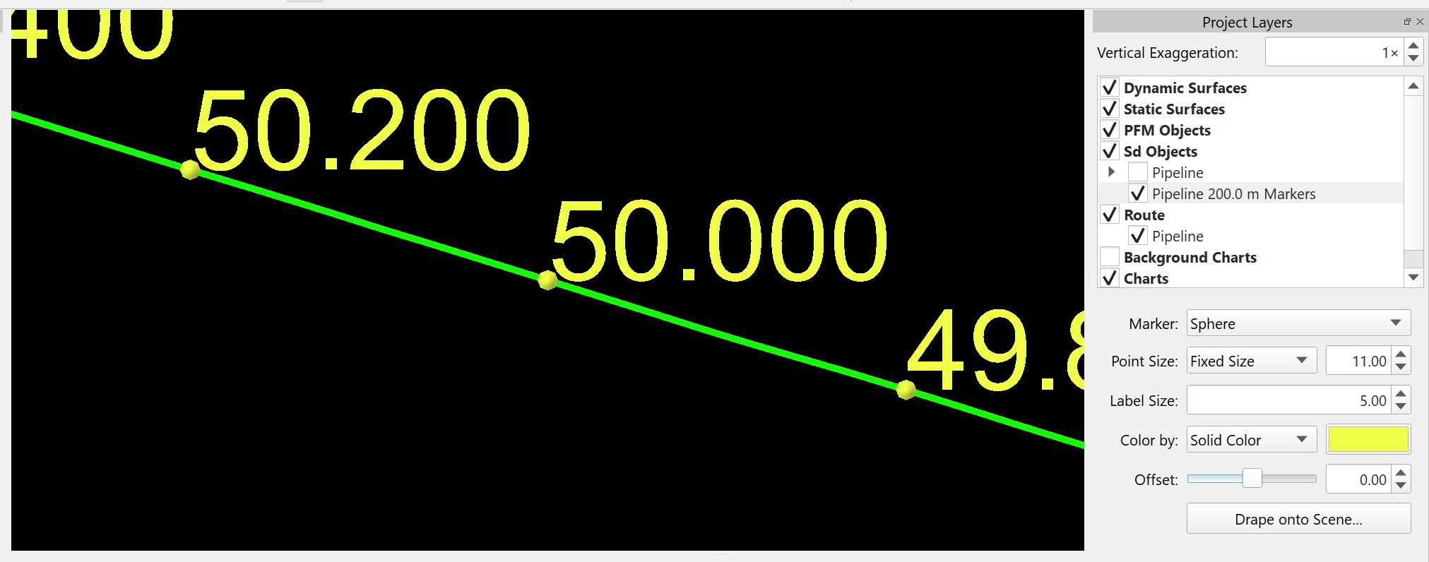
Once the labels are created, you can adjust size and coloring and can also configure how the label point is rendered in the mini attributes panel. In the example below, it is a sphere.
Improvements and Bug Fixes
- Geodetics
- Bug fixed for geodetic extraction from DB/QPD pairs
- Linked Objects
- DB/QPD pairs working better for sub-sea platforms that do not have a heading sensor, heading is extracted from the QPD object track now
- Shifting Tools
- Common User Experience for reporting, high-level access to export actions with new auto-export that saves critical reporting elements after the tool is successfully run (see graphic in highlights section above)
- Common User Experience for the Adjust Vertical and Horizontal Shift Tools to force the user to select which files or Dynamic Surfaces they want to shift
- Common User Experience for reporting, high-level access to export actions with new auto-export that saves critical reporting elements after the tool is successfully run (see graphic in highlights section above)
- Varying Vertical Shift Tool
- Added ability to specify Area of Computation to bring into alignment with the Static Vertical Shift Tool
- Fixed bug where sampling interval was not set during first run of the tool
- Added header to time-series ASCII export and changed time format to YYYY-MM-DD HH:MM:SS.SSS
- Fixed a crash when applying a shift to lines with a blend where some lines have a pre-existing shift and some lines do not
- Horizontal Shift Tool
- Improved consistency on how contours are displayed between the main Scene and the Horizontal Shift Tool, specifically the resolution
- Fixed bug where shifting windows had different sizes due to length of the surface file names
- Added new capability to do contour matching as a second method of assessing horizontal shifts, primarily for areas that don't have many linear or discrete seabed features (see graphic in highlights section above)
- Fixed bug where depth range for the various surfaces was not correctly used when using a Static Surface as the reference surface
- Fixed a bug where the easting/northing shifts were swapped
- Fixed a bug where the ASCII output had the wrong sign convention for the shift values
- CAD
- Arc sections of QGF are now drawn correctly, including when a QGF is selected for use as a Route
- QGF files, once converted to Sd format, will inherit the QGF line thickness
- Line thickness can now be controlled for all Sd line objects
- KP
- Label markers can be added to a Route via the right-click context menu from the selected Route in the Project Layers (see graphic in highlights section above)
- Geo picks export now has header, including for the KP and DX fields
- Label markers can be added to a Route via the right-click context menu from the selected Route in the Project Layers (see graphic in highlights section above)
- Slice Editor
- Dock context menu has a delay added to avoid accidental selection of a menu option with an accidentally quick mouse click and release, there is now a minimum time between click and release before an action will be triggered
- Removing an item from Sd Objects while slice editing will no longer exit the Slice Editor
- Time-Series Editor
- Fixed a bug where the new segment shifting was applying the graphical shift in the incorrect direction due to not respecting the sensor's sign convention, only affected roll and pitch sensor shifting
- Deleting a section in the time-series editor now correctly removes all data for the corresponding time span in the resulting QPD, previously this only removed the data if a user forced a manual ray trace calculation
- Fixed an issue displaying True Heave data in the time series editor caused by the GPS week rollover
- 3D Editor
- Show/Hide Files now works correctly when using slice editing in the standalone 3D editor
- Swath Editor
- Put the internal / external selection modes back in the Swath Editor toolbar that was removed in 2.3.0
- Fixed a water column rendering issue which would sometimes cause Qimera to freeze when viewing high density water column
- Surfaces
- Fixed an issue where survey lines would render below a Surface when the vertical exaggeration was set to 0.01
- Fixed an issue when using a selection to clip a Dynamic Surface when creating a Snapshot as a Static Surface
- Fixed an issue with displaying a density grid color map ramp
- Fixed an issue where the uncertainty color map histogram showed all values at 0.01
- Patch Test Tool
- Fixed the Patch Test reporting when transmit and receiver multibeam locations are different but the offsets are applied to both transmitter and receiver
- Allow for the vertical exaggeration to be changed the the Patch Test Plot and the Wobble Analysis Plot by holding the CTRL key and using the mouse wheel
- Exporting
- Made the default folder prompt default to a project folder instead of the last imported path for image and Dynamic Surface exporting
- Vessel Editor
- Fixed an issue where imported SBET files had duplicate time stamped vessel entries in the vessel editor
- Processing Settings
- Fixed an off by one error when doing beam blocking
- Stability Improvements
- Fixed a crash when appending lines to a dynamic surface and opening the 3D editor or slice editor during the append operation
- Fixed line rendering that sometimes resulted in random crashes
- Fixed a crash when importing 1000+ GSF files into Qimera
- Fixed a crash when using the measure tool and switching to a different selection or tool
- Fixed a crash when using the Time-Series Multiplot tool
- Fixed a crash when selecting a line to view in the Time-Series Editor
- Miscellaneous
- Cleaned up empty metadata folders that were being accidentally created in Qimera 2.3.0
- The scroll select now supports using Alt + left click to move the selection to the mouse location
- Added option to set horizontal and vertical uncertainty columns in the Add Large ASCII Processed Points import
- Fixed a beam angle precision issue when importing FAU files and there are large outliers in the first few pings
- Fixed a zoom message pop-up when selecting a tide station
Voting System
In this release, we have completed 16 Suggestions from users, which satisfies 145 votes. For more information, see our Voting System Policy and Using the Voting System.
The Voting System helps us to continue improving our software products. Vote or provide feedback and participate in the process by tracking, watching and commenting on issues!
The Feedback Project helps us to continue improving our software products. Vote or implement feedback and participate in the process by tracking, watching and commenting on issues!
Vote
Click on the icon above and vote on or create a Suggestion issue!

