This dialog closes the previous project if one is open and creates a new empty project.
General Description
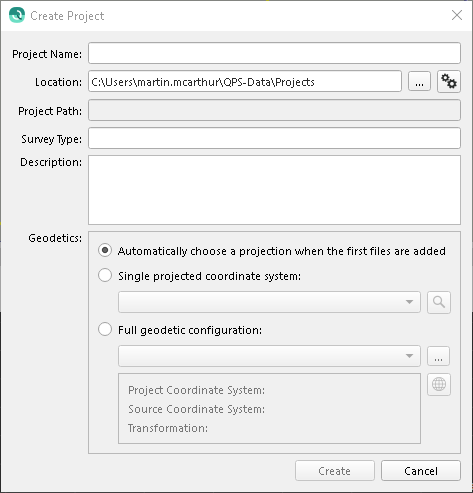
This dialog has the following options. The layout on disk of the project is described here.
Project Name
Enter the name you want for your project. Qimera will create a folder with this name in the Location directory.
Location
This is the directory path where your project folder will be created. To change it, simply click on the Browse button and browse to a new folder.
Project Path
This shows the full path at which the project folder will be created.
Survey Type
A free form, optional field describing the type of survey being conducted.
Description
Use this section to describe your project. This information will be saved in the qpsproject.xml file and can be edited using the Project Properties dialog option of the Main Menu bar.
Geodetics
This section specifies the geodetic configuration of the project. Every project has a projected coordinate reference system (CRS) describing all the data inside the project. While data may be imported from or exported to other coordinate systems, the project coordinate system will be used as the CRS for data storage and processing.
Choose Automatically choose a projection when the first files are added to have the application attempt to select an appropriate projected CRS when the first files are added to the project.
If the first files added use a projected CRS, that CRS will become the project CRS.
If the first files added use a geographic CRS, the application will select the appropriate WGS 84 UTM Zone based on the location of the data.
If the first files added lack a CRS, the user may be prompted to explicitly choose one.
Choose Single projected coordinate system to specify a predefined CRS.
Click the dropdown to quickly search coordinate systems by name or EPSG number.
Or click the magnifying glass button to open a dialog with advanced search capabilities.
Choose Full geodetic configuration for complete control over the project's geodetic settings.
Click the dropdown to quickly search known configurations.
Click the ... button to load an existing configuration from a .wkt or .db file.