
Technical Note: Importing data that is referenced to a custom transformation
Summary
Version 7.9.5 of FMGT, released Oct 13, 2020 includes a fix to enable a limited means of selecting a custom transformation to which imported data is referenced to.
Who should read this?
This change was implemented for FMGT users that are using a custom QPS geodetic transformation and who have exported GSFs from Qimera using that transformation. This document shows you how to get FMGT to respect this custom geodetic configuration since it does not have the same flexibility in setting up project geodetics as Qimera does.
What are the changes?
Via the Files→Add Source Files import path, the Coordinate System selection dialog has several new capabilities:
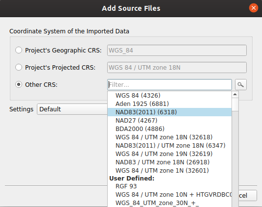
It is now possible to select the project's CRS (Coordinate Reference System), either geographic or projected, as the reference coordinate system of the imported data. For most users this will be nothing more than a convenience, but in certain circumstances it is essential in order to import source data in the correct CRS. See sections below for more details.
Why was this change made?
It is not currently possible to select a custom CRS (via WKT or any other means) during the import of Source Data in FMGT. This change enables a means to match a source file's CRS to that of the project.
Who does this impact?
This is an important change for users that have source data that is referenced to a unique datum via a custom transformation. An example of this would be a specific epoch (realization) of NAD 83 that includes custom transformation parameters.
Here's an example of a workflow that requires this functionality:
1) Data is imported into a Qimera project with geodetics that include a custom transformation. This may have been via a Qinsy DB that had originally defined that custom transformation, or by manually setting up the Qimera project CRS.
2) GSFs are exported from the Qimera project. These GSFs contain Latitudes and Longitudes that are referenced to the custom coordinate system outlined in #1.
There is currently no way to create an FMGT project and manually configure a custom transformation. The project CRS must be set to 'Auto-compute' and either a DB/QPD pair, or an SD reference surface, used to initialize the CRS to include the custom transformation. This specific initialization must be done before any other source data is imported.
3) A new FMGT project is created, ensuring that the 'Auto-compute output coordinate system' checkbox is checked. A DB/QPD pair or Qimera SD reference surface is then brought in to initialize the CRS to include the custom transformation.
4) The GSFs from #2 are then brought in. When the dialog page shown above is encountered, the default option will be 'Project's Geographic CRS'. This is the correct option for this import provided the project's CRS has been correctly configured via step #3.