
Edit Coordinate System
Edit Coordinate System dialog edits or creates a new coordinate reference system. The name change indicates whether it will edit or create. If the name is a built in EPSG CRS it will always rename it and create a new CRS and place it in the user-defined CRS section. There is no way to directly edit EPSG CRS's. You can however edit existing user-defined CRS's. If you wish to change the parameters in the new CRS they must be edited directly in the CRS box (pasting of text is, of course, possible, too).
Starting in version 7.6.0 has a new custom transformation section to allow an interface with coordinate operations available in the latest EPSG Geodetic Database. This is an advanced feature for those who want more direct control over the transformation between a selected CRS (coordinate reference system) and WGS84. In addition, unit correction has been expanded to cover all EPSG-listed linear and angular units.
Well-Known Text format (WKT)
Fledermaus suite stores and transmits it CRS's in a format called Well Known Text. The specification of it can be read at http://www.geoapi.org/3.0/javadoc/org/opengis/referencing/doc-files/WKT.html. This is version 1, and while there is a more complete (and complex) ISO version of WKT it is not used in Fledermaus. For the most part, these follow the OGC rules, with the notable exception that a Fledermaus specific keyword "TRANSFORM" was necessary to describe the full transformation options available in Fledermaus. This is now used in preference to the TOWGS84 transformation. OGC keywords can be seen at http://sis.apache.org/tables/CoordinateOperationMethods.html. This custom keyword is replaced if possible with OGC compliant WKT if it is exported to another software.
Unit Correction
Unit selection should be used to correct what is felt to be an incorrect or incomplete unit. Some of the other parameters are in the WKT (Well Known Text) string are in the units, and will not be converted. For example false northing parameter will be in the units specified in a projected CRS. If you change the units from meters to feet you are saying that the units were specified wrong and the value will stay the same but the present units will change. In addition, if you see a WKT unit string that says "international feet", for example, and wish to improve it with an EPSG code you can select "feet" EPSG code 9002. It is possible to change the linear unit and then alter all the affected parameters with unit conversion.
Transformation Selection
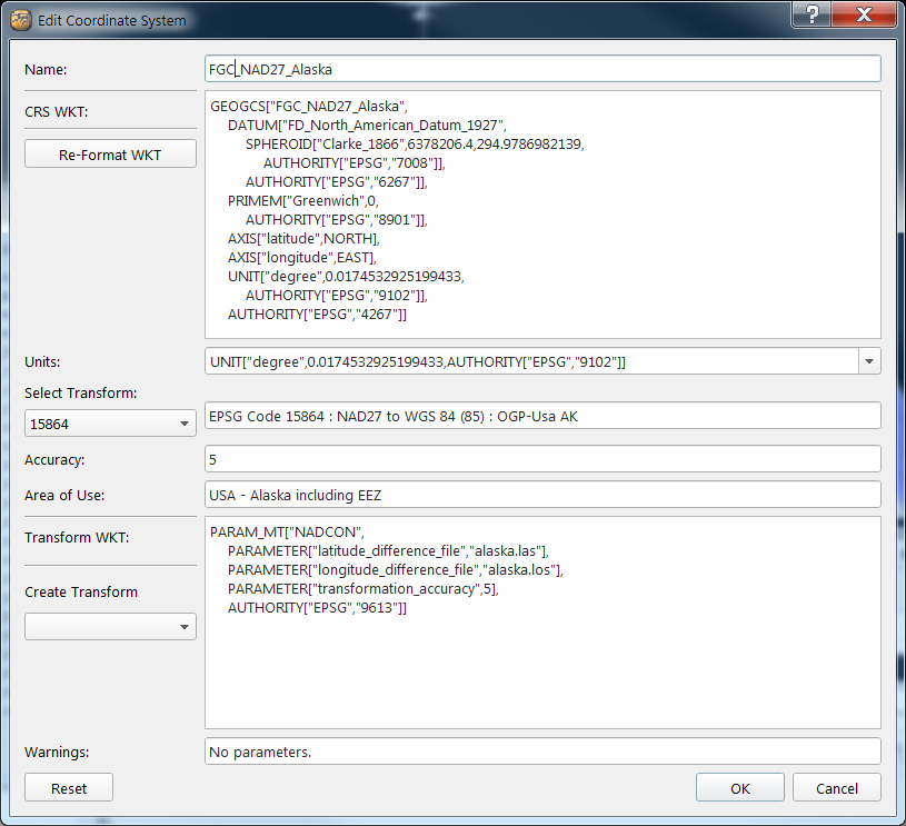
One reason to create a custom CRS with a specific datum transformation would be if you are going to be doing transformations between two geographic CRS's in which there is no indication of the region, and you need a region-specific transformation. For example, if you are transforming within Alaska State Plane Zone 1 (FP_NAD27_Alaska_zone_1) the region is built into the CRS, and the most accurate transformation for that region will be included. However With just a geographic transformation FG_NAD27 to FG_WGS_84 in which your data is in the Alaska state there is no possible way to select a regional transformation on initialization of the CRS, and instead it will select the most common transformation, which for NAD27 is NADCON CONUS. To select another you must create a specific user-defined CRS. Also you may want to use a grid that is not included with the installation, in this case you would have to create a custom CRS in the same way.
You can select the transformation with the select transform dropdown box. An easy way to examine them is click on the box then use the up and down arrow keys to advance down the list. There are more than one transformations available for a region, but you should select it based on what grid files you have available and also the stated accuracy (alaska.las and alaska.los files are include in the installation). In general, grid shifts (NADCON, NTv2, and grd files) are the most accurate, 7 parameter shifts are next then 3 parameter shifts are the least accurate. However a transformation specific to the region of interest is always best. The accuracy number is the maximum meters of error you should expect in the transformation. To install more grid files, examine the next section.
While very accurate, one limitation of grid shifts is that they are bound to a very specific rectangular area (unless they are global grid shifts) and outside that bound they create no transformation, so if your data is not or only partially covered by the grid bounds it can lead to some errors in the transformation. If that occurs to your data, the next step is to create a different reserve transformation that will give valid results over a larger area. In that case, you should repeat the process one of the 7 parameter or 3 parameter shifts based on the region. If there is no transformation available, then a simple ellipsoidal projection is done, which will have an unknown, possibly large error.
Creation of a Custom Transformation
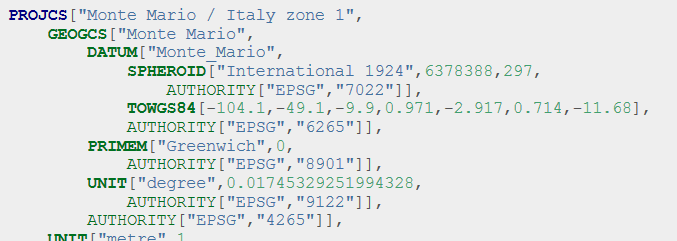
To create a custom transformation from an outside source, you can click on the drop down under "Create Transform". This will create a blank transformation WKT, which then can be edited with the text editor. In version 7.5 and before the transformations were embedded into the main WKT string as a TOWGS84 string. Now they are in a TRANSFORM WKT string underneath the CRS definition. The equivalent to TOWGS84 is a "position vector". So if you have documentation that contains a TOWGS84 set 7 parameters, these can transferred by manually typing in the data in the same order into a position vector transformation. Once you have started to edit parameters in the transformation part of the dialog, it's important to not select any other transform, otherwise it will overwrite your work.
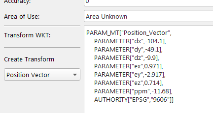
Note you should be cautious that if your 7 parameter transformation of the CRS is "coordinate frame" then you need to enter "Coordinate_Frame" as the PARAM_MT type. These are similar but different transformation that can lead to errors if you get this wrong. We still support TOWGS84 strings in user-defined CRS's, but the preferred way is to use the transform WKT.
Installation of grid files
Some transformation to grid files will appear that are not installed with the software because of legal or size issues. For example Canadian provincial grids are supported but because of legal restrictions must be obtained separately and installed. You can download them and drop them into the <program files>\QPS\<app>\resources\QINSy_Geodetics\Shift subdirectory. For Windows ensure that you have administrative privileges and if it is 64-bit put it into the Program Files directory while 32-bit applications it must be put into the Program Files (x86) directory. This assumes the default installation under Windows, if the files have been installed elsewhere a search must be done for the QINSy_Geodetics sub-directory. For the Macintosh platform this is the /Library/Application Support/nl.qps/Fledermaus/resources directory and for Linux this will be need to be in a way specific to your binary installation.